Very heavy rain continues to fall in the Montreal area. When I got home from work I had 46mm in the gauge or just under 2 inches here on Ile Perrot, that was at 7pm. I just went out to check on it at 9pm and there is an unbelievable 80mm now or just over three inches since it began early this morning. The culprit is strong low pressure off the east coast of the US pumping in a long plume of moisture from the tropics. The storm is producing flooding from southern Quebec all the way into the Carolina's at this hour. The heavy rain will continue overnight with at least another 20mm forecast. Radar is showing heavy rain across the metro region with some thunderstorms across upstate New York. Other rainfall totals as of 8pm were 51.6mm at St. Anicet, 54.7mm at Brockville and 31.6mm at Kemptville.
A flood watch is in effect for all of Vermont and New York. There are also flood warnings in effect for several regions including Clinton, Franklin and Essex Counties in upstate New York. Flooding is occurring along the Ausable River in northern New York. High winds are also beginning to affect southern portions of Vermont and New York. Wind gusts to 50mph may occur.
Thursday, September 30, 2010
Powerful east coast storm
 A plume of moisture stretches from a major storm east of Florida northward well into southern Quebec. Below: Storm clouds gather to the south of the island of Montreal. SB pic
HEAVY RAINFALL WARNING
Metro Montreal
The remains of tropical storm Nicole (that developed and dissipated yesterday), a frontal boundary and strong low pressure off the Florida coast are morphing into a strong fall storm along the eastern Seaboard. A variety of warnings and watches stretch from Ontario and Quebec south towards the Florida coast. The hardest hit regions so far have been the Carolina's north towards the middle Atlantic. The heavy rain has produced major flooding in North Carolina, with a three day rain total in excess of 20 inches in Wilmington. This morning a tornado watch is in effect for a large swath of the middle Atlantic region as clusters of thunderstorms swirl in off the Atlantic with some rotation possible. The Outer Banks will be hammered today with high surf, ocean overwash and coastal flooding. Wind warnings are also in effect from central New York southward.
For upstate New York, Vermont, southwest Quebec and extreme eastern Ontario, the rain will begin shortly and continue through mid day Friday. The heaviest rain is still well to our south but expected to
 arrive during the day today. Heavy rain warnings are in effect for all of southern Quebec and from Cornwall and Lancaster east in Ontario. Expect 50-80mm (2-3 inches) of rain in the next 24-36 hours. Some flooding is possible especially in metro regions. Across New York and Vermont, flash flood watches are in effect. Minor to moderate flooding along area waterways is possible today according to the NWS in Burlington. Numerous flight delays and ground stops are already occurring along the east coast of the US.
Wednesday, September 29, 2010
Meet Nicole
Heavy rain swept across large areas of the east yesterday including Ontario and Quebec. Ottawa had 33mm putting it right on track for the wettest September on record. The current record is 173mm set in 1945. In Montreal about 30mm fell across the city with isolated pockets of heavier rain in late afternoon thunderstorms. We were on the warm and tropical side of the system with temperatures reaching 27C in Burlington, Vermont and 25C in Montreal. It remains muggy this morning with a gusty southwest winds that will continue most of the day. Our break from the rain will be short lived as another low pressure area is getting organized near Cuba this morning. The system is expected to develop into tropical storm Nicole and move northeast towards the Florida coast. The system has prompted tropical storm warnings for Florida, the Bahamas and Cuba this morning. The storm has yet to be named but is expected to reach tropical storm status today. The forecast track has it moving along the Florida coast and inland over the Carolina's. Heavy rain has drenched the Carolina coast in the last few days with over 14 inches at Wilmington including an inch in one hour this morning. Flooding is occurring there.
By late Thursday the storm is expected to be moving northward along the east coast of the US towards the northeast and New England. Flood watches have been posted for all of New York and Vermont, and rainfall amounts could be quite impressive on Thursday and Friday with 3-5 inches (75-125mm) forecast within a 24 hour period. Warnings and Watches may be extended north of the border into southern Quebec later today. More information will become available today as the forecast path becomes a little more clear. The precipitation will begin late Thursday in Montreal and taper off Friday. It will turn much colder this weekend.
By late Thursday the storm is expected to be moving northward along the east coast of the US towards the northeast and New England. Flood watches have been posted for all of New York and Vermont, and rainfall amounts could be quite impressive on Thursday and Friday with 3-5 inches (75-125mm) forecast within a 24 hour period. Warnings and Watches may be extended north of the border into southern Quebec later today. More information will become available today as the forecast path becomes a little more clear. The precipitation will begin late Thursday in Montreal and taper off Friday. It will turn much colder this weekend.
Tuesday, September 28, 2010
Tropical rains

Major flooding in Wilmington after 10 inches of rain yesterday.
Deep tropical moisture is streaming northward along the entire east coast this morning. The rain has been heavy at times in the region, with warnings in place north and west of metro Montreal. Around 10-20mm fell overnight with another 10-20mm expected today, with more where any thunderstorms occur by afternoon. This morning low pressure is near Lake Erie, and it will move north to lie near Ottawa later today. Montreal is on the warm side of the storm with the temperature expected to climb to at least 23C despite the clouds and showers. It is a muggy, tropical air mass, which can be felt this morning, with our temperature already above the normal daytime high for late September, at 18C.
Along the east coast the heavy rain has produced major flooding. Flood watches are in effect for the Washington DC area with warnings across the Carolina's. Yesterday Wilmington, NC had almost 10 inches (250mm) of rain the second heaviest recorded in a 24 hour period. The culprit is tropical moisture being fed north from a developing low pressure near Jamaica. A NOAA reserve hurricane hunter is scheduled to fly into that system today with the National Hurricane Center predicting and 80% chance it will become a named storm this week. There is concern from Florida towards the middle Atlantic that this system will produce even more heavy rain on already saturated ground. That story will play out as the week progresses. Locally the clouds and wet weather will continue well into Thursday before some clearing and cooler weather will move in. That forecast depends on the southern system.
** It has been a cool summer along the southern California coast, however that changed yesterday. Despite it being fall, Los Angeles recorded its warmest temperature ever at the USC station, with a high of 113F at 12:30pm. A half hour later the thermometer broke, so it may have been even warmer. That high was the warmest since record keeping began in 1877, and it surpassed the previous high of 112F set in 1990. It will be "cooler" today at 100F.
Monday, September 27, 2010
Heavy Rain
A wet and windy low pressure area over Tennessee is slowly lifting northward into the Ohio Valley and Great Lakes today. This system has produced a wide area of heavy rain from the southeast into the Carolina's. Flooding has been reported with some areas receiving 2 - 4 inches of rainfall (50-100mm). As the system lifts into Ontario, heavy rain will develop across eastern Ontario into southern Quebec. At this time 25-60mm is forecast with higher amounts locally due to thunderstorm activity. Montreal is forecasting 20-40mm of rain, just below warning criteria. Regions north and west of the city including Ottawa/Cornwall and Eastern Ontario will receive heavier rain and are under rainfall warnings for an excess of 50mm of rain. The rain will develop this evening and spread north and east overnight. It will not end until Wednesday when it tapers to showers. There are no flood or hydro concerns at this time, as the area is relatively dry and can accept this moisture without flooding. Do however make sure your catch basins and gutters are free of falling leaves and other debris.
Temperatures will be mild with this southern system, above normal today at 19C in the region, and into the 20's on Tuesday. Skies will partially clear by mid week and it will turn sharply colder with frost and dare I say a snowflake or two in the air in the highest elevations of the Townships, the Dacks and Greens by next weekend.
Temperatures will be mild with this southern system, above normal today at 19C in the region, and into the 20's on Tuesday. Skies will partially clear by mid week and it will turn sharply colder with frost and dare I say a snowflake or two in the air in the highest elevations of the Townships, the Dacks and Greens by next weekend.
Saturday, September 25, 2010
Bizarre warm front

Warm and cold battle over the west end of Montreal yesterday. Haze, low clouds and fog kept the Montreal temperature much colder than surrounding regions, but the sky was still beautiful. SB photos
What a weird weather day it was yesterday in Montreal and around the region. It truly was an epic battle between good (warm front) and evil (cold front). Well that is how I see it anyway, I do prefer the heat. When am I going to learn that warm fronts follow no rules in the St. Lawrence Valley? We found that out during the ice storm of 98. Fronts often get slowed to a crawl as they attempt to push the cold air off the valley floor. Yesterday for a spell Montreal was colder than the summit of Mt Washington, NH. Many regions in the province never experienced the warm air at all including Quebec City where the high was only 10C (the normal is 15C). Heavy rain also fell across central areas of the province with over 80mm in the Abitibi region.
That front yesterday separated unseasonably cold fall air to the north and east and record breaking summer heat to the south and west. At one point yesterday St Anicet was 29C while Montreal was 14C, we are located just 60km apart. The heat in Ontario broke numerous records including Toronto at 31C, Ottawa 29C and Kemptville 29C. As the battle continued well into the night it appeared the cold front had won with some showers and thunder around 8pm and the temperature still at 15C here in Montreal, but shortly after that the wind came out of the southwest finally and our mercury shot up to 23C at midnight, our high for the day. It remained warm overnight with temperatures in the 20's before a cool down today. We are partly sunny at this hour and 18C.
 one point yesterday St Anicet was 29C while Montreal was 14C, we are located just 60km apart. The heat in Ontario broke numerous records including Toronto at 31C, Ottawa 29C and Kemptville 29C. As the battle continued well into the night it appeared the cold front had won with some showers and thunder around 8pm and the temperature still at 15C here in Montreal, but shortly after that the wind came out of the southwest finally and our mercury shot up to 23C at midnight, our high for the day. It remained warm overnight with temperatures in the 20's before a cool down today. We are partly sunny at this hour and 18C.
Friday, September 24, 2010
Pesky northeast winds
Northeast winds are slowly veering to the southwest across southern Quebec at this hour driving out the low clouds and fog. It has taken the entire day for the cold northeast winds to abate and the warmer air begin to move in. Such was not the case in Ontario where temperatures soared into the low 30’s across the southwest. The rise was impressive to say the least. At 11am Ottawa was at 11C, by 4pm they were 27C. Lancaster, ON and St. Anicet, QC just southwest of Montreal are at 26C now while we have struggled to reach 16C.
Toronto rose to 31C with strong winds of 50 gusting to 80km/h. It is like a hair dryer is turned on full force once the southwest winds begin to kick in. Montreal should easily make it to 25C in the next hour or two before the sun sets. A cold front tonight will bring us back to normal temperatures for the weekend along with a few showers.
Just for comparison, Whitehorse in the Yukon is under a snowfall warning for 10cm of snow. It is –1C and snowing at the moment.
Warm air streaming north
12:45 update: A persistent northeast wind here in the St. Lawrence Valley has kept our temperatures at a very cool 11C at the airport in Montreal and only 8C at Quebec City. Meanwhile Toronto is up to 30C behind the warm front and Burlington, Vermont 23C. Look for breaks in the cloud soon to allow our temperature to rise. We may not have enough daylight to reach 25C as I thought we would, however lets see how the afternoon moves along.
It is a cool and wet morning across the St. Lawrence Valley today with temperatures on brisk northeast winds at only 10C in Montreal. Major changes are just to our south, as a warm front is lifting north of the valley this morning. The heavy rain along the front overnight left about 38mm (1.5") in my gauge on Ile Perrot. The rain is almost done for the time being as the front lifts north into the Laurentians. Behind this front record breaking warm air is streaming into upstate New York, Ontario and eventually southwest Quebec. For example Watertown, New York jumped from 56F to 73F (14C to 23C) in one hour overnight. High temperatures across the region are forecast in the 77 to 86F (25 to 30C) range today. Montreal is officially forecasting 22C, however I believe with the clearing to our southwest we should be warmer than that. A cold front will arrive by evening and put an end to the one day heat with showers and thunderstorms into the overnight period. The weekend looks unsettled at times but decent overall. Some showers are possible both days and it will be much cooler, only around 17C. Most of the weekend should be dry.
Another factor today in advance of the cold front will be a strong southwest winds. Strong wind warnings are flying along the rivers and lakes as winds gust between 30 and 50km/h and even higher in some locations.
Tropical Storm Matthew
Matthew developed yesterday east of the Central American coastline. This morning the storm is about 170 miles east of the Nicaragua/Honduras border and moving west at 16mph. This system has prompted warnings along the coast with landfall expected later tonight. Afterwards computer models differ on a forecast track but look for the storm to lift north across the Yucatan area over the weekend and possibly into the southern Gulf of Mexico by Monday.
Thursday, September 23, 2010
Fall 2010 is here

The full harvest moon shines behind Michigan's Ludington Lighthouse (Photograph by Jeff Kiessel, Ludington Daily News/AP)
Fall arrived last evening at 11:09, with very little fanfare and under a full harvest moon as we said goodbye to one of the warmest summers recorded here in eastern North America. September did not disappoint in keeping up with the warm summer. Our average normal high in Montreal is 19.7C and to date we are running at 21.6C. We have had a few cool nights lately and some scattered frost, but for the most part overnight lows have been warmer as well at 11.8C compared to the normal of 9.4C. It has been dry with only 50.8mm of rain to date, well below the normal of 92.6mm. Most of that 50mm fell on only two days. The colors are beginning to pop as the reds on the maples have appeared after the cool longer nights this past weekend.
Post tropical storm Igor continues to meander around Baffin Island. The storm continues to produce very strong winds of over 100km/h across far northern Quebec and Ungava Bay with warnings in place for those regions. The clean up continues in Newfoundland with early damage estimates in excess of $25 million. Damage is widespread including at least two dozen communities cut off by road and bridge washouts.
Meanwhile forecasters at the National Hurricane Center are watching an area of disturbed weather in the Caribbean seas southeast of the Yucatan region. A NOAA recon flight will investigate the system later today, and it could become a depression. Most previous storms have been well out in the Atlantic, so this when bears watching as a possible threat to the US Gulf Coast.
Above right: Flooding in Newfoundland from Igor (Globe & Mail)
Fall arrived last evening at 11:09, with very little fanfare and under a full harvest moon as we said goodbye to one of the warmest summers recorded here in eastern North America. September did not disappoint in keeping up with the warm summer. Our average normal high in Montreal is 19.7C and to date we are running at 21.6C. We have had a few cool nights lately and some scattered frost, but for the most part overnight lows have been warmer as well at 11.8C compared to the normal of 9.4C. It has been dry with only 50.8mm of rain to date, well below the normal of 92.6mm. Most of that 50mm fell on only two days. The colors are beginning to pop as the reds on the maples have appeared after the cool longer nights this past weekend.
Post tropical storm Igor continues to meander around Baffin Island. The storm continues to produce very strong winds of over 100km/h across far northern Quebec and Ungava Bay with warnings in place for those regions. The clean up continues in Newfoundland with early damage estimates in excess of $25 million. Damage is widespread including at least two dozen communities cut off by road
 and bridge washouts.
Meanwhile forecasters at the National Hurricane Center are watching an area of disturbed weather in the Caribbean seas southeast of the Yucatan region. A NOAA recon flight will investigate the system later today, and it could become a depression. Most previous storms have been well out in the Atlantic, so this when bears watching as a possible threat to the US Gulf Coast.
Above right: Flooding in Newfoundland from Igor (Globe & Mail)
Wednesday, September 22, 2010
What a weather day
 CBC News - damage in Newfoundland
Visit the CBC Storm Centre for more photos.
September 21, the last full day of summer, will be remembered across this country for some impressive weather events. We had many areas receive their first frost, including southern Quebec away from the city, as well as measurable snow on the ground in Banff. Meanwhile the second land falling hurricane of this 2010 season to hit Canada swept into Newfoundland. Hurricane Igor pounded the province with heavy rain, hurricane force winds and a storm surge. The result was widespread damage and power outages as well as one fatality. Hard hit Bonavista had over 200mm of rain including 69mm in a two hour period before the rain gauge failed. Winds were beyond impressive, well over the 120km/h hurricane threshold. The peak gust with the storm was 172 km/h at Cape Pine. St. John's reported damage, power outages and travel delays as winds gusted to 137 km/h. Igor is now post tropical and located 550km northeast of St. Anthony's.
Meanwhile warm and humid air filtered into southern Ontario yesterday. A strong fall cold front pressed into the region around Lake Huron late last night producing heavy thunderstorms. The storm cut power two thousands and claimed the life of a Hydro worker in Port Elgin.
FALL ARRIVES at 11:09pm today, enjoy the last full day of summer in
 Montreal. The region is expecting showers with a rumble of thunder possible followed by clearing skies and temperatures in the low 20's. Low pressure will bring cooler weather and rain tomorrow and Friday, right on schedule as the seasons change.
Thunderstorm damage in Ontario (CTV.ca)
Tuesday, September 21, 2010
Igor pounds Newfoundland
 CBC News
5pm Update: Lots of damage being reported across eastern Newfoundland including one fatality. Power outages are widespread, roads and bridges have been washed out and trees are down. The roof was torn off the hospital on Bell Island. Gander has no water as power is out at the reservoir. Bonavista has been cut off after a bridge was washed away. Nearly 200mm of rain fell there in the last 24 hours. Newfoundland power has reported unprecedented call volume today.
Hurricane Igor is now in its post tropical state, but don’t tell that to the residents of Newfoundland. The storm has produced some of the worst damage in recent memory today as it assaulted the province. Numerous communities have declared states of emergency including St, John’s where public transit has been pulled off the road. Widespread flooding has been reported in the eastern portion of the province after more than 200mm of rain fell at St. Lawrence and across the region. Numerous coastal communities have been cut off by flooding and road washouts. The winds have been fierce gusting at over 150km/h. In the last hour the following wind speeds were observed, NW 123G154 km/h at Bonavista with a pressure of only 966mb. Gander was NNW 72 km/h, Port Aux Basques NNW 104G138 km/h, Sagona Island 103G123 km/h, Twillingate gusting to 131km/h and St. John’s 117 km/h. Newfoundland Power is reporting widespread outages across the province.
Hurricane Igor nearing Newfoundland

A major storm is underway in Newfoundland this morning, as Hurricane Igor is expected to pass just east of the Avalon while transitioning to a very powerful extratropical storm. Winds are currently 75mph (120km/h) at the center of Igor as the storm races northeast at 67km/h. The center is about 240km south of Cape Race this morning. The weather has already began to deteriorate along the coast with strong winds, pounding surf and heavy rain. St. Lawrence has already recorded 90mm of rain with amounts in excess of 200mm possible. Such heavy rain will cause flooding and possible washouts of area roads. Winds are very impressive as well in Newfoundland. In the last hour a gust to 132km/h was reported on Sagona Island (See A on the Google map below). Other winds speeds observed were 73km/h at Cape Race, and 79km/h at Burgeo.
A tropical storm warning is in effect for the Avalon, Bonavista and Burin Peninsula, with a hurricane watch for the immediate coast. Being that hurricane force winds are already reported that may be upgraded soon. Igor is expected to intensify today with rain and wind extending outward from the center and he becomes more of a mid latitude storm an
 d less of a tropical system. Regardless the results will be the same for Newfoundland and Labrador, heavy flooding rains and strong winds capable of taking down trees and power lines. This will be an all day storm as the system moves slightly east of the province and then wraps around to the north and northwest and heads towards Baffin Island.
Monday, September 20, 2010
Igor sweeps Bermuda - FROST in summer?
 Lots to talk about on this Monday morning. We start with Bermuda and Hurricane Igor. Thankfully the once borderline category 5 storm was only a 1 when it moved across Bermuda late Sunday and overnight (Reuters Photo on right). This was enough to send pounding surf onto area roads as well as topple trees and power lines. A more complete assessment of the damage will be done at daybreak, but so so far it looks better than expected. Power is out to most of the island. The storm this morning is 60 miles north northwest of Bermuda and heading northeast. The next target for Igor will be Newfoundland later on Tuesday. A tropical storm watch is in effect for the Avalon and Burin Peninsula's and heavy rain warning for the interior sections. Forecasters expect 90km/h winds and rainfall of between 50-150mm. Hurricane force winds can be expected along the Grand Banks
 (NHC forecast track below left shows how close Igor will come to Newfoundland).
Summer Frost
Portions of Alberta are expecting snow and frost tonight as the very chilly end to summer continues across most of the country. Fall arrives on Wednesday, but we may have a summer frost tonight in many portions of the country. Calgary is expecting rain to turn to wet snow with a couple of centimetres possible tonight. Heavy Snowfall Warnings are in effect for Jasper and Hinton with over 5cm expected. Meanwhile frost warnings are in effect for a large portion of southern Quebec and New England. Temperatures under clear moonlit skies will drop very close to freezing tonight, especially away from the water and urban areas. Ile Perrot was down to 7C this morning with 8C at the airport, and we may drop down to between 2 and 4C tonight. Tuesday and Wednesday will see temperatures begin to rise to above normal levels (23 to 25C) with abundant sunshine.
Saturday, September 18, 2010
Karl inland over Mexico
Just a brief update this morning on Hurricane Karl. The storm is inland over central Mexico with the biggest threat at this time being heavy rain. The once category 3 storm made landfall just north of Veracruz yesterday around 2pm.
A sign of the seasons this morning in the east, we are down to 6C here on Ile Perrot. Frost advisories are in effect for the Laurentians, Adirondacks and Green Mountains as well as the colder valley locations away from water. It will be a sunny day with temperatures warming into the 21C or 70F range.
A sign of the seasons this morning in the east, we are down to 6C here on Ile Perrot. Frost advisories are in effect for the Laurentians, Adirondacks and Green Mountains as well as the colder valley locations away from water. It will be a sunny day with temperatures warming into the 21C or 70F range.
Friday, September 17, 2010
Karl a category 3
 Hurricane Karl forecast track inland over Mexico (NOAA).
Hurricane Karl is a mere 50 miles northeast of Veracruz, Mexico this morning with 120mph winds. The storm intensified rapidly overnight and is expected to further strengthen before landfall later today along the central Mexican Gulf Coast. This will be one of the strongest hurricanes in recent memory to hit this region. Surge flooding could be in the order of 12-15 feet along the coast with heavy rain expected as well. The storm will move inland tonight and head in a westerly direction towards Mexico City while weakening. It will be a big rain machine with the potential for 15 inches or more of rain over the interior mountains. There is a serious risk of flash flooding and deadly mudslides. Hurricane warnings are in effect along the coast, with tropical storm force winds already spreading inland in the warning area.
Weekend Update:
Meanwhile Montreal had about 20mm of rain late yesterday and overnight. It is cool with clearing skies this morning. Look for sun and clouds mixed with high temperatures below normal at 17C. it will warm Saturday under partly cloudy skies to about 21C. Believe it or not it is 1C this morning in Calgary with light rain/snow mix and -3C in Edmonton with widespread frost. Where did the summer go so fast?
Thursday, September 16, 2010
Karl heads for Mexico

It is a very busy evening in the weather world tonight. In Montreal a windy and rainy Great Lakes storm is providing us with early October weather when it is still summer. It is a chilly 10C with steady rain and a cold northeast wind. Further south heavy thunderstorms rattled across Metro New York City and New Jersey. High winds of 60mph toppled power lines and numerous trees, killing one person and destroying several cars. The National Weather Service will be investigating the damage on Friday to see if it was a tornado or straight line winds.
Across the west frost warnings are in effect for large portions of Saskatchewan and Alberta as the coldest air of the season moves south. Some flurries are possible over the upcoming weekend. Speaking of snow, Mt. Washington in New Hampshire recorded its first snowfall of the season yesterday with 0.4" of the white stuff. Just a dusting but surely a sign of things to come. So after a very hot summer across the east, this is quite a rapid and shocking turn around.
Karl was upgraded to a hurricane today in the Bay of Campeche between the Yucatan and the central Mexican state of Veracruz. Hurricane warnings are in effect for the coast from Veracruz to Cabo Rojo as the system moves slowly west with increasing winds and seas expected. Karl has 80 mph winds and indications are the storm may continue to intensify and approach major hurricane status of category 3 by landfall on Friday.
Rainy weather

Tropical storm Karl stirring up the waters off the Yucatan coast yesterday. AP Photo
A gusty low pressure area has taken shape over the Great Lakes and is moving into southwest Ontario this morning. This is the first system of the season with very fall like characteristics, I am sure there will be many more! An area of heavy rain and thunderstorms associated with the low is already into the London to Windsor corridor. This rain will move north and east today across the GTA and up the 401 and into southern Quebec by this evening. The rain could be quite steady at times with 25-40mm expected across Ontario into western Quebec and upstate New York. Temperatures will be cool for the next day or so. Saturday looks decent with just a slight chance of a shower and temperatures warming over 20C.
Tropical Update: While Julia and Igor have been very impressive hurricanes it is Tropical storm Karl that is making headlines this morning. Karl slammed into the Yucatan yesterday with heavy rain, high seas and 50mph winds. This was enough to produce flooding and some power outages. This morning the storm is back over the Gulf of Mexico and strengthening. A NOAA Recon flight recently reported a lowering pressure and Karl could become a hurricane later today or Friday. Winds are now at 65mph and the center is about 385 miles east of Tuxpan. A hurricane watch is now in effect for the Mexican Gulf Coast from La Cruz to Palma Sola, with landfall expected late Friday in the state of Veracruz.
Meanwhile Julia is weakening with 105mph over the open waters of the Atlantic. Igor is 955 miles south southeast of Bermuda, and is a very powerful category 4 storm with 145mph. This storm will come very close to Bermuda on the weekend. Swells from Igor are already spreading into the Bahamas and along the US southeast coast.
Wednesday, September 15, 2010
Igor - Julia - Karl
 In Montreal it is breezy and cool this morning with area temperatures below 10C. Yesterday we had a very lively sky at sunset with showers and clouds playing with the setting sun. A spectacular rainbow developed and I was able to snap this photo before is dissipated seconds later.
Igor, Julia and Karl, sounds like a pop group from the 60's but it is the latest trio of storms in the Atlantic basin. Both Igor and Julia are major hurricanes meandering in the open waters of the Atlantic. Igor remains a potent category 4 storm with 145mph winds. This storm is a serious threat to Bermuda this coming weekend and will bear watching. Julia meanwhile has become a major category 4 storm as well with 135 mph winds and is located about 525 miles west of the Cape Verde Islands. It appears that Julia will take a sharp northward turn during the forecast period and avoid all land. Tropical storm Karl developed yesterday with 65mph winds and is currently approaching the Yucatan coast of Mexico. Heavy rain and strong winds are forecast today before Karl moves back into the Gulf of Mexico. The storm will then threaten mainland northern Mexico by the weekend.
Tuesday, September 14, 2010
Tranquil week ahead
A cold front is well south and east of Montreal this morning, and the temperature is a chilly 13C. We may warm to 17C or so today if we see some sunny breaks. Another frontal boundary will slide across the area late this afternoon and overnight with some gusty showers. Much cooler air will spill into the valley tonight with lows all the way down to 5 to 7C. We will only recover to about 15C under mostly cloudy skies on Wednesday. The cool and partly cloudy weather will last into the weekend as a fall pattern begins to establish itself over the region. There is no warm late summer weather anywhere in sight for Montreal, southern Quebec or Ontario.
Tropical Update
In the tropics we have a a new hurricane, Julia. The storm is about 330 miles west of the Cape Verde Islands, moving away at 15mph. Julia has 75mph winds and further strengthening is forecast today. Meanwhile Hurricane Igor remains powerful and dangerous, a category 4 storm. Winds have lowered slightly to 135mph but a further increase in strength is likely today. The storm is 750 miles east of the northern Leeward islands. Both Igor and Julia will avoid land for next few days, however Igor will approach Bermuda by late in the weekend, possibly as a major hurricane. It appears Julia will remain over water right into the weekend.
Monday, September 13, 2010
Thunderstorms today

Is this the deal of the week?
I snapped this picture of a 1930's clunker under grey, drizzly skies yesterday afternoon in Morrisburg, Ontario.
A cold front to the west of Montreal across central Ontario will drop across the St. Lawrence and Ottawa Valley's this afternoon with a good risk of thunderstorms. Some of the storms could be feisty with heavy rain, gusty winds and some small hail. It will be mild with temperatures near 20C. The rest of the week looks like a repeat of last week with unsettled conditions, some cloud, some sun and the ever present risk of showers. Temperatures will be a little below normal in the 15 to 18C range. There is even the risk of patchy frost across the Townships, Laurentians and the areas to the south in New York and Vermont by Thursday morning.
TROPICAL UPDATE
IGOR: The tropics remain active this morning with a very strong and large hurricane Igor and a new storm Julia. Igor is almost a category 5 this morning with 150mph winds and a central pressure of 935mb. The storm is moving west at 13mph and at this time is no threat to any land. Igor is well developed with a 15 mile wide eye. The outflow remains good and further strengthening is expected today. At the end of the three day forecast, wind shear may begin to weaken Igor as he moves to lie well south of Bermuda.
JULIA: Meanwhile Tropical Storm Julia formed south of the Cape Verde Islands this morning, roughly in the same region that has produced most of the storms this season. The storm with 40mph winds is about 85 miles west southwest of the southernmost island. A tropical storm warning is in effect for the Caper Verde Islands as the storm moves west northwest at 14mph. Julia is forecast to strengthen further and head northwest. She could become a hurricane early this week.
Sunday, September 12, 2010
Hurricane Igor a monster

US Navy image of intense Hurricane Igor taken a few hours ago.
What happened today over the Atlantic? When I last checked, Igor was a mere tropical storm meandering slowly to the west. Today the storm has blossomed rapidly into a monster category 4 hurricane. At 9am this morning Igor was a category 1 storm with winds of 80mph and a central pressure of 988mb. As of 5pm this afternoon we were looking at a very intense and large hurricane Igor with 140mph and a pressure of 942mb. There is no reason to believe the storm won't grow even stronger in the next 24 hours. Fluctuations in strength are very common with major hurricanes, but the forecast out to 72 hours keeps Igor at major status, that is Cat 3 or higher. The storm is located 1065 miles east of the Lesser Antilles and no threat to land at the moment. All interests in Bermuda and along the North American east coast should monitor Igor this week.
Friday, September 10, 2010
Weekend Update
 Despite my denial, the weather is getting cooler. I toyed with the idea of putting heat on in the car this morning, but then went back in the house for a light jacket. I don't like to do either. I have an unwritten rule, no heat until at least October 1st. After a week long battle with that stubborn upper level low it appears clearing skies are just to our west in Ontario and on the way. Look for sun and clouds mixed this morning before a complete clearing sky by afternoon. The temperature will respond accordingly and reach 21C in southern Quebec and across the Seaway. Tonight under clear skies, it will be cool with some fog developing and lows of 9C (likely 11C in the city). Saturday will be spectacular, sunny and 23C in Montreal. Sunday and Monday will see an increase in clouds followed by showers. Temperatures will cool back into the teens. Low temperatures by late next week could flirt with the freezing point in the rural areas. Just a thought if you have a garden.
TROPICAL UPDATE
The remains of Tropical Storm Hermine are across Missouri and Arkansas today with more heavy rain and the potential for flash flooding. The system is slowly weakening. Meanwhile Tropical Storm Igor has temporarily been downgraded to a depression, however forecast models have the storm as a hurricane approaching the Leeward Islands by the middle of next week. We have not heard the last of Igor and I expect this system may become a big news item down the road.
Thursday, September 09, 2010
Sunshine returns for weekend

A persistent upper level low continues to spin over Quebec today with cloudy skies and afternoon showers possible. Some sunshine yesterday allowed the air to become quite unstable, and some of the showers has some bite to them, with even a rumble or two of thunder. The system will finally shift east tomorrow with sunshine developing and lasting into Saturday. Another round of showers is possible Sunday into early next week.
HERMINE
The remains of Tropical Storm Hermine continue to produce severe weather over Texas, Oklahoma and the southern plains. Heavy rain produced major flooding in Texas with two deaths reported. The severe weather was not limited to flooding, tornadoes were reported in Texas including a supper hour storm in the Dallas metroplex. The storm caused considerable damage to property, but no injures were reported.
IGOR
Tropical Storm Igor developed as expected yesterday just south of the Cape Verde Islands. The storm is drifting north at 2 mph and is poorly organized at this time. Conditions are expected to become more favorable for strengthening by Friday and Igor could become a hurricane early next week.
Wednesday, September 08, 2010
Unsettled week ahead
A typical fall pattern is upon us after the passage of a sharp cold front overnight. Decent thunderstorms last evening left about 13mm of rain in Montreal along with some gusty winds. However it was the spectacular lightning that stole the show, some of the best all season (see photo below). Behind the front temperatures will remain steady today around 20C (they have dropped to 15C in Ottawa and Toronto from highs near 28C yesterday) with gusty southwest winds. Tomorrow will be even cooler. Clouds will play with sunshine for most of the week, along with a decent chance of afternoon showers in the cool unstable air. This will be especially true if any sunshine develops, which tends to just mix the air up and make it that much more unstable.
HURRICANE News:
Hermine has moved inland over south Texas after drenching Mexico. Portions of the state had over 4 inches of rain with flooding reported this morning as far north as San Antonio. Along the coast 70mph winds caused minor damage and sporadic power outages. The remains of Hermine will move north into Oklahoma and Kansas with heavy rain. Mean while out in the far eastern Atlantic the parade of systems coming off the African coast continues. It looks like we have a 70% chance of another tropical depression forming just south of the Cape Verde Islands according to the National Hurricane Center. This breeding ground has produced Danielle, Earl and Fiona in the last couple of weeks. Look for a depression to form with the next 24 hours. If the system reaches 39mph it will be called Igor.
Image from www.stormpulse.com
HURRICANE News:
Hermine has moved inland over south Texas after drenching Mexico. Portions of the state had over 4 inches of rain with flooding reported this morning as far north as San Antonio. Along the coast 70mph winds caused minor damage and sporadic power outages. The remains of Hermine will move north into Oklahoma and Kansas with heavy rain. Mean
 while out in the far eastern Atlantic the parade of systems coming off the African coast continues. It looks like we have a 70% chance of another tropical depression forming just south of the Cape Verde Islands according to the National Hurricane Center. This breeding ground has produced Danielle, Earl and Fiona in the last couple of weeks. Look for a depression to form with the next 24 hours. If the system reaches 39mph it will be called Igor.
Image from www.stormpulse.com
Tuesday, September 07, 2010
Wicked Lightning

I took this video around 9pm tonight on L'Ile Perrot looking west. The lightning was vivid, some of the best this summer. ValleyWX Pic
The sun broke out today behind a warm front allowing the mercury to rise rapidly to 26C in Montreal and into the upper 20's in eastern Ontario. The warm and humid air is combining with a potent cold front tonight to produce some nasty thunderstorms across Ontario and Quebec. The first line went through around 9pm with intense lightning and some gusty winds. Warnings have now been issued for that line of storms as they slide southeast into the Richelieu Valley and Townships. Meanwhile a second line of storm stretches from Ottawa to the St. Lawrence River. These cells are moving east towards Montreal. Warnings for this line of storms have been issued for the Ottawa Valley between the west end of Montreal and the Ontario border. The activity should begin to taper off after midnight as the front moves east of the city.
Hermine lashes South Texas
Tropical storm Hermine has moved inland over extreme southern Texas this morning heading northward. The storm was nearing hurricane strength with winds gusting over 70mph as it made landfall in northern Mexico overnight. Hermine has been delivering strong winds in the 30 to 50mph range with rainfall of 1-3 inches per hour in the heaviest bands. Isolated tornadoes have also been reported in coastal Cameron County. Hermine will slowly move northward today across the Lone Star state with heavy rain as far north as Dallas expected. The rest of the Atlantic basin is quiet today.
Montreal: Some showers are moving across southern Quebec this morning in response to a warm front lifting north. The front should clear the Valley by noon and for a brief period place us in the warm sector. Partial sunshine and temperatures approaching 25C are likely. This evening a gusty cold front will move through Ontario and Quebec bringing the risk of more showers and thunderstorms along with cooler temperatures. The balance of the week will feature a frontal trough producing fall like unsettled conditions. Plenty of instability will lead to frequent afternoon showers, with temperatures in the 18 to 21C range for daytime highs, and 11 to 15C overnight.
Of note, a sign of the seasons in Alberta with frost warnings in effect tonight for central and southern portions of the province.
Monday, September 06, 2010
Weekend Recap
 Above & below right: Halifax on Saturday (Halifax Chronicle).
It was a busy weekend in the weather world, and that has continued into this Labor Day Monday. First, locally here in Montreal we had a very windy weekend. This was a result of multiple cold fronts moving in from our west along with the increase in northerly winds from Earl in Atlantic Canada. Winds gusted out of the southwest as strong as 70km/h in southern Quebec and up to 85km/h in eastern Ontario. There was even the occasional rumble of thunder on Sunday. There were scattered power outages reported in Ontario. In addition to the strong winds, temperatures were in a free fall all weekend. After tying the all time September record high on Friday at 33.5C, we struggled to only 18C yesterday,
 (thanks Nick for the correction). Today will be warmer under some partial sunshine, about 23C. Some showers tonight along a warm front followed by a warmer day Tuesday at 27C. The balance of the week will be variable with more clouds than sun, and almost - dare I say - fall like in the 20C range.
Here are some observations from Hurricane Earl across Atlantic Canada.The strongest winds reported were at Beaver Island at 135km/h, well above hurricane force. The most rain fell at Edmunston, NB at 76.5mm. In PEI, East Point had a wind of 98km/h, and in Wreckhouse, Nefoundland 129km/h. A buoy on the Scotian Slope reported 25.1 metre seas and one at the approach to Halifax Harbor 23.3 metres
This morning Earl is all but forgotten as clean up continues in Nova Scotia. To our south the remain of Gaston are located near Puerto Rico and showing some signs of regeneration. To my surprise the area of unsettled weather in the Gulf of Mexico became Tropical Storm Hermine overnight. Tropical Storm warnings are in effect for the Mexican coast and the south Texas Coast from the Rio Grande River to Baffin Bay. The storm is expected to move onshore early Tuesday with heavy rain and 50mph winds.
Saturday, September 04, 2010
Earl makes landfall
10:30pm Update: Earl's journey that started off the coast of Africa is almost complete as the system moves towards Newfoundland and Labrador. Winds are in the 75km/h range and the system is becoming extra tropical (loosing the tropical characteristics). In Halifax today and across Nova Scotia winds howled at hurricane force reaching over 120km/h with a peak gust to 135km/h. The winds tore down hundreds of trees and power lines leaving nearly 200,000 without power in the province. One death was attributed to the storm. I will have more, including photos from Nova Scotia tomorrow morning.
Here is a radar image of Earl as he nears the south coast of Nova Scotia between Lunenburg and Halifax within the last few hours.
11am Update: Selected Observations:
I think I may have found where Earl made landfall on the Canadian coast. At 11am, Western Head, Nova Scotia south of Halifax reported a pressure of 963mb. The last reported pressure in the center of Earl was 965mb.
Peak wind speeds so far, Beaver Island, 103km/h, Halifax SE 74G 111km/h, McNabs Island, SE90 G 109km/h.
Earl heads for Halifax

Earl in Canadian waters this morning just south of Yarmouth
Tropical Storm Earl is taking a slight wobble to the east and will likely move inland south of Halifax moving north across the province. Ironically with all the attention this storm has received, Canada will be Earl's first direct landfall. The other regions affected by Earl from the tropics and along the east coast were just brushed by the once powerful Hurricane.
A quick scan of observations at 10am AST showed winds in Halifax SE 48G 84km/h and in Lunenburg, ESE 84 G 102km/h. Radar is showing bands of heavy rain steadily moving through Nova Scotia. The storm is moving very fast and this should be a short duration event. The wind and rain will diminish late this afternoon in Nova Scotia. The western edge of the storm is also affecting portions of New Brunswick, PEI and Quebec. At 9am Earl was located about 115km south southeast of Yarmouth. Tropical Storm Warnings remain in effect for Nova Sctoia while inland warnings are posted for heavy rain and wind. It appears with the rapid movement of Earl that rainfall totals will be lower.
Friday, September 03, 2010
Earl Nova Scotia bound

Montreal remains sandwiched between an achingly slow cold front over Ontario and the western edge of the cloud shield from Earl to the southeast. This afternoon the spiral bands of clouds crossing the island of Montreal form the southeast were just a small reminder of what is lurking just off the east coast. At 8pm tonight Earl had 75mph winds and was about 155 miles south southwest of Nantucket. Warnings for tropical storm force winds are in effect for portions of the New Brunswick coast as well as most of Nova Scotia. Heavy rain and wind warnings are also in effect for the Lower North Shore of Quebec as well as the Gaspe region. Winds across Eastern Quebec and Atlantic Canada will be gusting between 70-100km/h. Rainfall across the region will be in the 30-40mm range. Earl is moving faster now at 23mph and should arrive in Nova Scotia by Saturday morning. As Earl becomes extra tropical and the wind field begins to spread out, winds will increase in the St. Lawrence Valley as far southwest as Montreal and gust 40-60km/h Saturday. There is a risk of showers as far west as Vermont and the Townships but that should be about it for Earl locally.
I found a few more pictures of damage, these from the Virginia Pilot, including the one above of the Sandbar Restaurant in Buxton. On our last day in Hatteras during the month of May we had supper there, sitting at the table on the left. The  restaurant is right on Pamlico Sound and no doubt bore the brunt of the 80mph winds that blew across Hatteras last night. The image on the right is NC 12 in Buxton, not far from the Cape Hatteras Lighthouse. The flood waters you see are actually from the soundside of the island.
 restaurant is right on Pamlico Sound and no doubt bore the brunt of the 80mph winds that blew across Hatteras last night. The image on the right is NC 12 in Buxton, not far from the Cape Hatteras Lighthouse. The flood waters you see are actually from the soundside of the island.
Hurricane Earl Update
 1PM Update: Montreal has just tied the temperature record for the date at 32.1C and we did it before 1pm. I really did not think we had a chance. Now thunderstorms are firing up in the tropical air over Ontario and moving east towards Quebec. They could become severe this afternoon into the evening. Meanwhile Earl continues to move away from the Outer Banks and is now setting his sights on Cape Cod and Nova Scotia. Peak wind gusts in North Carolina were 82mph at Oregon Inlet Marina, and 73mph on Ocracoke.
Here is the latest information I have on Hurricane Earl. As day breaks across the Outer Banks, winds have been the strongest they have been all night. In the last several hours gusts have been over 70mph on Hatteras Island with sustained winds in the 60mph range. Highway 12 has suffered ocean over wash and is closed near Mirlo Beach north of Rodanthe, and also in the Village of Frisco. Soundside flooding is now becoming a problem especially south of Avon with reports of 3 feet of water in Hatteras Village. Dare County officials will be getting out shortly to view any physical damage to homes and businesses, especially along the beachfront.
I am still trying to get information on Ocarcoke Island and Hyde County. The web cams are down on Silver Lake and my thoughts are that power may be out on the Island.
Montreal Weather: I have neglected our local weather of late. We continue very hot and humid for September with a tropical air mass well established here. The forecast is for hazy sun today with temperatures close to 32C (90F). The record is 32.2C set in 1953, we may come close to that. The tropical air will move east this weekend as northeast winds from the combination of low pressure over central Quebec and Earl begin to draw cooler air into the valley. You will notice on the satellite image above that the northern cirrus clouds of Hurricane Earl are approaching the Canadian border south of Montreal. If you look up in the sky to the south today you will see high cirrus from Earl. Combined with the tropical dew points and heat, and it almost feels like we are in the tropics and not southern Quebec.
Earl charging northward

 Above: Frisco Pier on Hatteras Island yesterday (Photo by Don Bowers) and above that photo the one I took in late May.
The center of Hurricane Earl this morning is about 85 miles east of Cape Hatteras, North Carolina and moving north northeast at 18mph. This appeared to be the storms closest approach to the Outer Banks. Overnight winds have gusted to hurricane force over Ocracoke and Hatteras Island with sustained winds close to 60mph. Surge and wave action have caused damage to dunes and roads. Nearly 3 inches of rain fell from midnight to 5am. There are reports that Highway 12 along the islands is under water in places and that flooding of 2 to 3 feet occurred in Hatteras Village. Highway 12 is closed at Oregon Inlet.
I also noticed a story on Frisco Pier that was badly damaged by recent storms. Portions of it fell into the pounding surf yesterday, and I would be very surprised if it survived the night. The pictures above are the one I took on a calm day in May followed by the one from Don Bowers on the Outer Banks yesterday. The full story is available at Island Free Press.
With Earl now pressing north, seas and winds will diminish along the Outer Banks, but increase along the coast from Virginia northward to Cape Cod. Hurricane Warnings remain posted for Cape Cod and the islands. Further north, a wide variety of high wind, heavy rain and storm warnings are in effect for Atlantic Canada and eastern Quebec. Our primary concern should be with the southern counties of coastal Nova Scotia and New Brunswick around the Bay of Fundy. These areas could experience significant flooding due to storm surge.
I will update more information at 8am this morning.
Thursday, September 02, 2010
Earl weakens slightly
 9:45 Update: A Hurricane Watch has been issued for the Nova Scotia coast from Medway Harbour to Digby.
I have been looking at observations from the Carolina coast and just offshore. Winds have been increasing into the 35mph range with one exception. Diamond Shoals buoy southeast of Cape Hatteras had a wind gust over 50 mph and 21 foot seas in the last hour.
The good news at 8pm is that Earl is now a category 2 storm with 110mph winds. The even better news is that the storm is now turning towards the north and looks like it is going to remain offshore enough to keep the strongest winds over the Atlantic. Strong winds are still expected in the 40-60mph range and perhaps gusting to hurricane force on Hatteras Island. The big concern will be the heavy surf and pounding waves that are producing ocean over wash on the fragile banks, threatening NC 12 as well as some oceanfront homes. High tide will occur around 2am. A quick scan of area observations shows winds gusting in the 20 to 30mph range. Hurricane Warnings remain in effect for the Outer Banks as well as Cape Cod and the islands tonight.
I hope our latest vacation home on Flambeau Road in Hatteras Village is doing ok tonight along with the rest of the residents of the Outer Banks. I can only imagine the view of the storm that the house is offering. A coastal low brought strong winds and rain when we were there in May and virtually wiped out the beach for the day. It must be very interesting there tonight.
New Hurricane Warnings
Here is an update to 1pm: Hurricane Earl is still a powerful storm with 140mph winds and is located about 300 miles from cape Hatteras. Here are the new series of warnings that are currently in effect.
Hurricane warnings are now in effect from Bogue Inlet, N.C., northeastward to the North Carolina/Virginia border, including the Pamlico and Albemarle sounds. A hurricane warning is also in effect for the coast of Massachusetts from Westport eastward around Cape Cod to Hull, including Martha's Vineyard and Nantucket Island. A tropical storm watch is also in effect for the coast of Nova Scotia from Port Maitland to Medway Harbour.
Hurricane warnings are now in effect from Bogue Inlet, N.C., northeastward to the North Carolina/Virginia border, including the Pamlico and Albemarle sounds. A hurricane warning is also in effect for the coast of Massachusetts from Westport eastward around Cape Cod to Hull, including Martha's Vineyard and Nantucket Island. A tropical storm watch is also in effect for the coast of Nova Scotia from Port Maitland to Medway Harbour.
Earl heads for Outer Banks
8:30AM Update: Environment Canada has posted A Tropical Storm Watch for Yarmouth, Shelburne and Queens Counties in southeastern Nova Scotia. More information to follow today on my lunch hour.
 The image above is from the Island Free Press (double click for more detail). It is an area I am so familiar with from my visits over the last 18 years, that I can almost see my car in that line up to leave Ocracoke Island and head north to Hatteras and the mainland. It was taken by Don Bowers last night as vacationers began to evacuate the 13.5 mile island. The narrow road you see in the photo is the north to south NC 12 with the Atlantic on the right and Pamlico sound on the left.
 The image above is from the Island Free Press (double click for more detail). It is an area I am so familiar with from my visits over the last 18 years, that I can almost see my car in that line up to leave Ocracoke Island and head north to Hatteras and the mainland. It was taken by Don Bowers last night as vacationers began to evacuate the 13.5 mile island. The narrow road you see in the photo is the north to south NC 12 with the Atlantic on the right and Pamlico sound on the left.
A wide variety of watches and warnings are in effect this morning for coastal areas from North Carolina north into Nova Scotia. Earl has begun to make a slight northward motion and is expected to approach Hatteras Island late today. Forecasters are confident the center will remain offshore, which means the strongest winds will remain offshore as well to the east of the center. However pounding surf and a storm surge of 3-5 feet will affect the low lying barrier islands of the Outer Banks. This will be plenty to cause erosion and major flooding along US 12. Evacuations have been underway since early yesterday with 35,000 moving inland from the Banks.
This morning it is a pleasant 24C in Buxton on Hatteras Island, ironically the same temperature as in Montreal 1600km to the north. The tropical air mass is well established along the entire east coast. Also visible on Buxton radar is the outer bands of Earl. Conditions will continue to deteriorate today with seas and winds increasing. The storm will pass east of the Cape tonight and up the east coast towards Nova Scotia late Friday. Earl is a Category 4 storm about 400 miles from the Carolina coast.
The storm should pass within 75 miles of the coast. Winds are currently at 145mph and a slow weakening process will begin within the next 24 hours as the storm races off to the northeast. With the storm off the coast most of the weather with Earl in the US will be confined to the immediate coast. That will change in Nova Scotia as Earl makes landfall there, but the storm will have weakened to a Cat 1 by then. More on that as we make it through today.
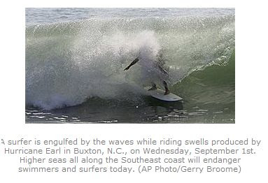
Wednesday, September 01, 2010
Earl UPDATE
The latest information from the Canadian Hurricane Centre on Earl is available HERE. Earl is expected to move into Nova Scotia on Saturday.
Meanwhile at 10pm tonight CNN is reporting that a Hurricane Hunter Aircraft measured flight level winds of 199 mph during a flight into Earl just before 10pm this evening. The measured gust was reported from a dropsonde in the eye wall. Earl is a large and very dangerous storm about 550 miles southeast of Cape Hatteras. The next update will be early tomorrow morning.
Meanwhile at 10pm tonight CNN is reporting that a Hurricane Hunter Aircraft measured flight level winds of 199 mph during a flight into Earl just before 10pm this evening. The measured gust was reported from a dropsonde in the eye wall. Earl is a large and very dangerous storm about 550 miles southeast of Cape Hatteras. The next update will be early tomorrow morning.
Earl a Category 4 once again

Earl southeast of Cape Hatteras with Nova Scotia at the top of the image.
Hurricane Earl's top wind speed has increased to 135 mph and Category 4 status once again. The storm is 630 miles southeast of Cape Hatteras moving northwest at 17mph. On this present course, hurricane conditions will arrive along the Outer Banks by midnight Thursday. The weather will deteriorate well in advance with winds and seas increasing as the day wears on. A manadatory evacuation has been ordered for both Ocracoke and Hatteras Islands. I spent two weeks there in May, you can visit some of my May entries on this blog for more details on the region. Forecasters expect Earl to brush the Outer Banks before heading north just off the coast towards Long Island, southern New England and eventually southern Nova Scotia. It is likely that we will have a land falling hurricane in Nova Scotia this weekend.
At present a hurricane warning is in effect from Bogue Inlet, North Carolina north to the Virginia/North Carolina border. North of there tropical storm watches and hurricane watches are posted to the Merrimack River on the New Hampshire border with Massachusetts.
Evacuations started today on Ocracoke Island with fees for ferry service to the mainland being suspended. A state of emergency has been declared for Hyde County.
Hurricane Earl Update
 NOAA image of Hurricane Earl this morning east of the Bahamas.
12PM Update: As of 11am Hurricane Warnings are flying for the North Carolina coast from Bogue Inlet north to the Virginia border including the Outer Banks and all sounds. A Hurricane Watch is now in effect northward to Cape Henlopen, Delaware.
HEATWAVE
Strong high pressure continues to pump tropical air into southern Quebec and eastern Ontario today. Poor air quality has resulted in smog warnings for both provinces and air quality alerts for upstate New York. The warm and humid air produced a record high of 32C in Montreal yesterday and we are forecasted to reach 33C today which would smash the record of 31.7C set in 1953. The normal high for September 1 is 22.4C and we are already at 24C this morning. The warm air will be with us until Friday. Afterwards a cold front from the Great Lakes as well as the western edge of Earl may affect our weather into Labor Day weekend.
HURRICANE Earl
Earl is 780 miles southeast of Cape Hatteras this morning. The storm has weakened slightly but remains a powerful Category 3 storm with 125mph winds. A Hurricane Watch is in effect for the North Carolina and Virginia coast from Surf City north to the Maryland border, this includes the fragile Outer Banks. Anyone who knows me or reads this blog on a regular basis knows of my attachment to Hatteras Island and the Outer Banks. While I am hoping for the best, each successive forecast track has pushed Earl slightly to the west. It appears the storm will approach the Carolina coast by late Thursday. Afterwards the entire northeast and Atlantic Canada is at risk for hurricane or tropical storm conditions. I imagine watches will be upgraded to warnings on the Outer Banks today and likely a watch may be needed further up the east coast. Seas are building today all along the coast. The main threat from Earl will be high surf and battering waves on the Outer Banks with ocean overwash and possible flooding along NC 12.
***This is a local statement for Hyde County, published on the Ocracoke Island Journal Blog. My significant other and myself have spent so many hours on Ocracoke, and many many moments at the Village Craftsman where the blog originates. I think we have more of their stock in our home than remains in the store. Read the local statement HERE.
**Tropical Storm Fiona is 70 miles northeast of Barbuda this morning with 60mph winds. She will affect the Leeward Islands today. Meanwhile another system is showing signs of organization off the African coast south of the Cape Verde Islands and we could have another named storm by the weekend.
Subscribe to:
Posts (Atom)