Monday, April 30, 2018

Flooding potential on the rise in southern Quebec

Minor flooding was reported along the Milles-Iles River in Laval over the weekend. (Radio Canada)
The miserably cold and wet month of April is finally drawing to a close today. Once the final data is digested, I think we will find that many parts of the country, including Montreal, had one of the coldest April's on record. As we move into May, the hope is warmer air will finally win over here in southern Quebec. First we have to deal with what should be a "normal" flood season, and at least at this point, nothing record breaking like 2017. Hydro Meteo has been monitoring the waterways across the province, and has issued flood watches for many regions. Locally, a flood watch in in effect for the Townships and Laval. While water levels are sharply rising, only minor flooding has been reported to date. Over the weekend, 25 to 50mm of rain was reported across the area. With the ground saturated from earlier precipitation and snowmelt, most of this will runoff directly into rivers and streams. Hydro Meteo issued an update at 6am Monday, reporting significant rises in rivers across the Beauce, Eastern Townships, Quebec City, Mauricie and Lanaudiere. They are reminding residents who live close to waterways or in flood prone areas to remain vigilant.

The upper level low that produced the rainy and cold weekend, will meander into New Hampshire today, and eventually Atlantic Canada by Tuesday. More showers can be expected in Montreal today, with a cool high of 10C (50F). On Tuesday, skies will slowly clear, followed by the warmest surge of air so far this season. Expect a high of 17C (63F) Tuesday, and up to 24C (75F) Wednesday. Unfortunately another frontal system will arrive on Thursday, with more showers and perhaps even the first round of thunderstorms this year. Rainfall amounts may be significant in southern Quebec, adding to the current flood concerns.

Tuesday, April 17, 2018

Record setting storm slowly moving east

Hydro Ottawa poles were snapped in half after 9 hours of freezing rain across the National Capital region. (Hydro Ottawa Photo)
The storm that produced hour upon hour of freezing rain across southern Ontario and Quebec, is slowly releasing its grip on the region. The system was responsible for 9 hours of freezing rain in Montreal, the longest April event ever, dating back to 1953. Between 10 and 20mm of ice fell on the city and suburbs, delaying flights and closing most schools. A peak wind gust of 63km/h occurred at Trudeau Airport. Scattered power outages were also reported, mainly off island to the south and west.

In Ontario, the storm was much worse. Over 80mm of frozen precipitation (rain and ice pellets) fell on Toronto over 24 hours. A peak wind gust of 98km/h occurred at Billy Bishop Airport. In Ottawa and Gatineau, 9 hours of freezing rain deposited 28mm of ice. Power was out to over 60,000 homes in the region, including 44,000 on the Quebec side of the border. The ice snapped hydro poles in half in Ottawa. The Ontario Provincial Police reported hundreds of accidents over the weekend and Monday as a result of the late season storm. The Toronto Blue Jays baseball game was postponed Monday night due to ice falling from the CN Tower onto the roof of Rogers Centre.

The same storm was responsible for heavy snow across the central Great Lakes. Wiarton, Ontario reported 39.6cm of snow, while Green Bay, Wisconsin was hit with their second largest snowstorm ever, 24.2 inches. You have to go back 130 years to March 1-2, 1888 for the largest storm, 29 inches. On the warm side of the storm, widespread severe thunderstorms stretched from Arkansas to the Carolinas. Several tornadoes occurred as well as large hail. Widespread damage was reported, along with multiple injuries and at least four fatalities.

Sunday, April 15, 2018

Icy start to work week for Montreal

So far, the worst of the icy weather has remained in Ontario this weekend. That will change today as freezing rain develops in Montreal this afternoon. Hundreds of accidents were reported by the Ontario Provincial Police on Saturday alone. (TWN Photo)
Freezing Rain Warning in effect for southern Quebec, including metro Montreal. 

The frontal boundary that left Montreal shivering in unseasonably cold air Saturday, has pushed far enough south to keep most of the precipitation away form the city for now. That being said, it won't stay there, and the bad news is that the worst of the weather returns to Montreal for the Monday commute. On Saturday, the bulk of snow and ice pellets remained in Ontario and New York. The result was hundreds of accidents reported by the OPP, as well as 10,000 residents without power in Ontario alone. Highway 401 was closed in at least two locations due to accidents. In Montreal, the weather was cold and windy, with just a dusting of snow overnight.

This morning, the weather remains cold, at -5C (23F) on L'Ile Perrot, combined with a northeast wind of up to 50km/h, the temperature feels like -15 C (5F). Icy precipitation will spread into southern Quebec this afternoon, as the front slowly begins to lift north again. Strong low pressure will move along the front tonight and Monday, spreading freezing rain and rain across the province. Temperatures will remain below freezing in Montreal for at least the next 24 hours. There is a real concern that a significant amount of freezing rain will fall. Expect a very poor commute Monday morning in Montreal. I would also anticipate power outages across southern Quebec due to ice accretion and gusty northeast winds. Expect winds between 50-70km/h in the St. Lawrence Valley Sunday and Monday. The freezing rain will eventually change to rain in Montreal late in the day Monday.

Friday, April 13, 2018

Storm to impact Quebec and Ontario with icy mix

A complex late season winter storm will impact Ontario and Quebec this weekend. (AccuWeather.com)
A complex and intense weather system will begin to impact southern Ontario late Friday, with a messy mix of freezing rain and snow. The precipitation will spread into extreme southern Quebec early Saturday. A frontal boundary over central New York will be the focus for the precipitation as it attempts to lift northward on Saturday. Low pressure will then slowly move along the front Sunday bringing another round of precipitation into the region. At the same time, strong high pressure anchored over central Quebec, will provide unseasonably cold air across the region.

Montreal can expect light snow on Saturday, with perhaps 5cm accumulating. The heaviest precipitation on Saturday will be across southern Ontario, where freezing rain and snowfall warnings have been posted. The possibility exists for a significant amount of freezing rain along the north shore of Lake Ontario into the St. Lawrence Valley. Further north snow will be the main form of precipitation. All regions, including Montreal can expect gusty northeast winds up to 60km/h through Sunday. Temperatures will fall below freezing overnight and remain there through most of the upcoming weekend in Montreal. On Sunday, heavier precipitation will arrive in Montreal, with the freezing rain lifting from southern Ontario into southern Quebec. This is a very dangerous late season storm, with  numerous impacts expected across the entire area. On Monday heavy rain is forecast, as the system slowly lifts northeast across Quebec.

I will post further updates early Saturday morning.

Wednesday, April 11, 2018

Challenging weekend forecast may bring snow and freezing rain to Quebec

A stationary front will be the focus of heavy precipitation over the weekend. The front will also represent the dividing line between very warm air to the south and more cold weather here in Montreal. (AccuWeather.com)
A very difficult, complex forecast period lies ahead for portions of southern Ontario and Quebec. Wednesday will likely be the best day of the week, with sunshine and fairly mild temperatures. Clouds will increase this afternoon, as a week clipper system crosses the region. We may have a few spotty showers or flurries along with the cloud cover.

On Thursday, a second weak area of low pressure will follow a similar path across southern Quebec, with light rain expected. Skies will briefly clear on Friday, before the real fun begins. A sharp frontal boundary will position itself across portions of central New York State and New England. North of the front, cold weather will prevail, with temperatures at or slightly below freezing. South of the front, temperatures will surge into the low to middle 20s.  The big question is where will the front settle? As the front meanders across the region through the weekend, strong low pressure will approach from the Midwest US. The storm will be packed with moisture. A mix of heavy wet snow, freezing rain, rain and thunderstorms is expected to develop on Saturday from the central US towards the Great Lakes, Ontario and Quebec. The potential exists for a significant freezing rain event for many, as well as heavy wet snow in some locations. Heavy rain will cause sharp rises in rivers and streams increasing the concern for flooding.

At this time amounts and type of precipitation are very difficult to nail down. One thing is certain, we will have a decent amount of precipitation, perhaps in excess of 50mm (2 inches) through Sunday night. Strong winds are also likely with this storm. Weather watches and warnings will likely be necessary for a portion of our forecast region as the event draws closer. Stay tuned as this will be a fluid event with a highly changeable forecast.

Sunday, April 08, 2018

Chilly start to April to continue across most of Canada

I would like to express my deepest condolences to the residents of Humboldt and the province of Saskatchewan. I was saddened to hear the news of the terrible accident involving the Broncos hockey club. I wish the players, families and first responders strength and courage as they begin the long recovery process.

Strong winds in east end Montreal, toppled this sign onto several cars Wednesday night, April 4. The wind cut power to nearly 50,000 customers in Quebec. (Radio Canada Photo)
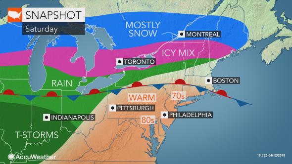
April Chill
The miserably cold start to April continues across most of Canada. From coast to coast, Canadians are dealing with cold and snow. The low on Friday morning in Edmonton was a bone-chilling -25C (-13F), the coldest since 1975. The storm on April 4 produced over 25mm of rain in Montreal, but the fierce winds were the real story. Gusts exceeded 90km/h in many parts of Ontario and Quebec, with a peak gust of 89km/h recorded at both Trudeau Airport and south shore St Hubert. In Ontario, the strongest wind was at Point Petre, at 102km/h. In New York, 75mph winds were recorded east of Lake Erie, while a gust to 100mph was measured on Mount Mansfield in Vermont.The wind knocked power out to thousands, including 50,000 in Quebec. There was also reports of structural and tree damage. Heavy snow fell northeast of Montreal, with 27cm at Quebec City. Blowing snow closed Highway 20 east of Quebec City to Riviere-du-Loup.

A tree lies across a house in western New York on April 4. (AccuWeather.com)
Cold, blustery weather followed the storm, with a high in Montreal of only -3C (27F) on Thursday, 4C (39F) Friday and a windy 3C (38F) Saturday. The average high for this time of year should be 9C (48F). Snow showers have been accompanying the cold, making it feel like February.

As we look ahead to the upcoming week, the picture looks the same for southern Quebec and Ontario. Expect below normal temperatures with periods of showers or flurries scattered through the week. At best, high temperatures may reach 7C (45F), still well below normal. Overnight lows will dip below freezing. At this rate, the icy piles of dirty snow still around, may last into May. I just want to rake my lawn!

Monday, April 02, 2018

Strong spring storm to spread snow and rain across Quebec

Where has spring gone? Many parts of Canada as well as the northern US continue to experience cold and snowy weather. More of the same is forecast through at least the middle of April.
Deepening low pressure is forecast to move from Colorado towards the lower Great Lakes on Tuesday. A warm front well in advance of the storm center, will push across the region Tuesday night, followed by a potent cold front Wednesday evening. South and east of the storm track, heavy rain is expected, with 25 to 40mm possible. Heavy rainfall warnings have been issued for southern Quebec, including metro Montreal. North and west of the track, snow will be the dominant precipitation type. Some locations from the upper Ottawa Valley into the Laurentians, may pick up 20 to 30cm of heavy wet snow. Environment Canada has posted snowfall warnings for Mont Tremblant as well as Sainte-Agathe and Saint-Sauvuer. Warnings are also in effect for the upper Ottawa Valley including Pembroke and Petawawa. Portions of western Quebec and extreme eastern Ontario may have mixed precipitation to start late Tuesday, but should transition to rain quickly. Behind the storm, rain will change to snow in Ottawa Wednesday night, with 5cm forecast.

Strong Winds
Temperatures will warm above freezing in Montreal on Tuesday, reaching a high of 4C (39F), with 6C (43F) expected on Wednesday. A strong cold front will arrive late Wednesday into Thursday morning, accompanied by very strong northwest winds. In the St. Lawrence Valley, gusts may reach 90km/h. Wind warnings may be necessary for Montreal late wednesday afternoon. Unseasonably cold air will rush back into southern Quebec, with lows plummeting by Thursday morning to -10C (14F) in Montreal. The cold, unsettled weather will be with us through the middle of the month, with several opportunities for snow across the northern tier of the US as well as central and eastern Canada. The next chance for snow could come as early as Friday morning here in Montreal, as a clipper system moves south of the city. More on that as the week progresses.