Sunday, June 27, 2021

Heat Warning in effect for Montreal

Find ways to stay cool this week, as Canada swelters from coast to coast.

Heat Warning in effect for metro Montreal.

Mascouche Tornado CLICK HERE

What a weather week it has been across Canada. From drought to tornadoes and historic heat, we have seen it all. I will begin with the current weather, it is a very warm and muggy Sunday morning in Montreal, with the temperature already at 24C (76F) at 6am. We are on the way to a high of 32C (90F), with humidex values approaching 40C. Overnight lows will remain well-above 21C (70F) in the city. Environment Canada has posted a heat warning for the region through Tuesday. Warm and humid air is being forced northward by high pressure located off the middle Atlantic coast.

A strengthening Bermuda high will pump tropical air into southern Quebec this week. High temperatures combined with elevated humidity levels will make it feel closer to 40C. Meanwhile western Canada is baking in in historic heat. (AccuWeather.com)

Along the periphery of that heat bubble, showers and thunderstorms have been firing up. Some of the storms were strong on Saturday, with tornadoes reported in central Ontario, into Michigan and Illinois. In Quebec it was much need rainfall, with 21.8mm at Trudeau Airport, 17mm here on Ile Perrot. Every drop helps, but we remain well-below normal in the precipitation department, a drought that stretches back to winter. Saturday's rainfall brings the monthly total in Montreal to 47.2mm, still 50 percent of normal for June. This comes after an extremely dry April and May.

Monday's deadly tornado in Mascouche, was one of four to impact the province that day. The total for the season has already reached 8 in Quebec, we normally only have 5 for the entire year. (CTV News Montreal)

Quebec Tornado Outbreak

The Northern Tornadoes Project out of Western University in London, Ontario has completed their preliminary assessment of Monday's severe weather outbreak in Quebec. The strong thunderstorms produced 4 separate tornadoes. The first occurred south of Montreal at Saint-Valentin near the US border. The tornado touched down at 335pm with 115km/h winds, and EF-0 on the Enhance Fujita Scale. The second tornado was the deadly storm that swept across Mascouche, with widespread severe damage and one fatality. It was an EF-2 with estimated winds of over 180km/h. Between 4 and 5pm two more tornadoes were observed at Saint-Celestin (EF-0, 115km/h winds) and Saint Narcisse-de-Beaurivage (EF-1, 150km/h winds).

Historic Heatwave

 An historic heatwave is gripping portions of western Canada and the Pacific Northwest. Temperatures on Saturday soared into the upper 30s and middle 40s. Over 50 high temperature records were broken in B.C., including 43.2C (110F) at Lytton. Temperatures will be even warmer on Sunday and Monday, with a high of 47C forecast for the B.C. interior. If that occurs it will become the warmest temperature ever recorded in Canada. The current record dates back to the dirty thirties, when Yellow Grass, Saskatchewan reached 45C (113F) on July 5, 1937.

The heatwave has even impacted the large coastal cities, with Victoria and Vancouver reaching into the middle 30s. Portland, Oregon recorded there warmest day ever on Saturday, reaching 108F (42.2C) surpassing the  benchmark of 107F set in 1981.

The heatwave is forecast to persist all week as hot high pressure builds in from the deserts of the southwest US. The heat will spared east into Alberta and Saskatchewan as the week prevails. 

Sunday, June 20, 2021

Strong thunderstorms for the first day of summer

Lightning illuminates the sky over Ile Perrot during recent thunderstorms. There have not been to many storms this season to date, but a frontal boundary is poised to generate severe thunderstorms Monday afternoon across southern Quebec. Be alert to rapidly changing weather conditions if you have any outdoor activities planned for Monday. (Valley Weather Photo)

Elevated risk for severe thunderstorms Monday afternoon in Montreal

Summer officially arrives at 11:32 PM Sunday evening, and right on cue, a warm and humid airmass will arrive across southwestern Quebec. Sunday was a sunny and pleasant day, with temperatures topping out in the high 20s, 29C (85F) here on Ile Perrot, along with low humidity. The evening will remain dry and mild, with clouds on the increase after midnight. Lows will remain warm, in the upper teens.

A warm front will lift across the region during the pre-dawn hours Monday, accompanied by scattered showers and perhaps a rumble of thunder. Skies will then partially clear Monday morning, with strong, gusty southwest winds briefly transporting tropical air into the St. Lawrence Valley. Temperatures will rise quickly into the upper 20s and low 30s across the region. Humidity levels will rise as well, making for a muggy day. The airmass will become quite unstable, with plenty of energy to fuel developing storms.

A frontal boundary is expected to move into the region late in the day, with strong to severe thunderstorms developing in advance of the trough. The storms are expected to form across eastern Ontario by 2pm and move east-northeast along the boundary into southern Quebec. At this time, there is an elevated risk of severe weather. The main threat will be strong gusty winds up to 100km/h, but large hail, torrential downpours and dangerous lightning are possible as well. A severe thunderstorm watch will likely be issued by Environment Canada some time Monday morning.

If you have any outdoor plans on Monday, keep and eye to the sky. This is especially true if you will be out on the open water. The threat for severe weather will diminish into the evening hours Monday. Skies will partially clear on Tuesday, along with cooler, less humid conditions. High temperatures will be in the low 20s for Montreal.

Monday, June 14, 2021

Much needed rain for southern Quebec and Ontario

A spectacular sunrise, taken through the annular solar eclipse last Thursday morning on Ile Perrot. Much needed rain is forecast to start this week along with muggy weather. (Valley Weather Photo)

The moderate drought that has stretched throughout the spring has left much of the region desperate for rainfall. Overnight, thunderstorms produced around 8mm of rain in Montreal, but the monthly departure from normal remains at around 75 percent below the long-term average. This after only 15 to 25 percent of normal precipitation fell last month, including the driest May on record for Montreal. More showers and thunderstorms are forecast this afternoon into the evening hours as a frontal boundary moves across the St. Lawrence Valley. Some of the storms may be strong, with heavy rain and small hail the main threat. The weather will be warm and muggy, with highs near 25C (77F).

More showers are expected on Tuesday with slightly cooler temperatures around 22C (72F). Over the two day period, up to 25mm (1 inch) of rain is possible, with more in heavier thunderstorms. 

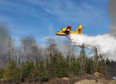
As the dry weather persists over a large portion of the province, SOPFEU has had to seek assistance from B.C., Alberta and New Brunswick. Several teams have arrived in Quebec to help battle 16 active fires burning across the province. (SOPFEU Photo) 

Quebec is currently extremely dry, with the Montreal region and the Laurentians under extreme fire conditions. SOPFEU, the provincial department responsible for forest fire prevention has called in assistance from B.C., Alberta and New Brunswick. At present, there are 16 active fires burning in the province. A widespread burn ban was put in place last Thursday across 12 regions of the province. This year there have already been 357 fires, well above the ten year average of 204. The fires have consumed over 7000 hectares (17,300 acres).

The lack of rain has had a serious impact on agriculture across the region. Locally on Île Perrot, the stress on vegetation due to the lack of precipitation can be seen just about everywhere. Grass is turning brown and some trees are dropping leaves. Municipalities on Ile Perrot as well as Vaudreuil-Dorion have watering restrictions in place. In the case of Notre-Dame-de-L'Île-Perrot where I live, we are only permitted to water for two hours between 8 to 10pm on alternating even/odd days, depending on your address. Check with your municipality for any restrictions. Fines can be quite high and from what I understand are being enforced.

It will take a few months of above normal rainfall to begin to narrow the deficit in Montreal. Unfortunately we are heading into our typically hottest, driest weather of the year, highly dependent on thunderstorm activity.

Monday, June 07, 2021

Heat warning in effect for Montreal and Ottawa

Thunderstorms on Saturday afternoon across portions of southern Quebec only helped increase the humidity across the city. The warmest day of the current heatwave is forecast on Monday, with a high of 34C for Montreal. Overnight lows will remain sultry, dropping to 24C (76F).

Widespread heat warnings are in effect for southern Quebec including metro Montreal, eastern Ontario, including Ottawa and the Champlain Valley of New York and Vermont. The combination of very warm temperatures and elevated humidity will make it feel closer to 40C today. Drink plenty of water and relax outdoor activities when possible. Dry to spend a portion of the day in air conditioned space. Montreal is already at 23C (73F) at 6am.

Monday will be the warmest day of the current heatwave, with high temperatures expected into the middle 30s across portions of southern Quebec, along with high humidity. We can expect a record-breaking high of 34C (94F) in Montreal, which should surpass the previous benchmark of 33.4C set in 1999. Gusty winds are also expected today from the southwest 30 to 50km/h, helping to pull in tropical air from the Gulf of Mexico.

On Sunday, the heat and humidity built up quickly after the afternoon thunderstorms on Saturday. The high was 31.4C (89F) in Montreal, also a record for the date beating the 2005 high of 30.8C (87F). The storms on Saturday became rather strong for portions of the city, with close to 15mm of rain falling in less than 30 minutes at Trudeau Airport. Locally, some parts of Montreal received over 30mm, but I only measured 4mm here on Ile Perrot, as the storms passed northeast of my location. Strong winds were observed as well, along with frequent lightning. 

Monday should be dry for most of us, with just a slight risk of a shower or storm in the mountains well north and southeast of the St. Lawrence Valley. Showers and thunderstorms will increase on Tuesday ahead of a backdoor cold front. That front will cross the region early Wednesday, ushering in drier and slightly cooler air. Before then, expect a hot day Monday and Tuesday. The high on Tuesday will be near 31C, dropping to 30C for Wednesday. Overnight lows will be very warm, in the low to middle 20s in Montreal. Much cooler, more pleasant air arrives for Thursday, with a high of  24C (76F) forecast and lower humidity. 

Friday, June 04, 2021

Driest May on record for Montreal

The 5.6mm of rain that fell on Thursday in Montreal has knocked down the dust for few hours. Dry, hot weather is forecast to return by Sunday. The region desperately needs rain after a record-breaking low 12.1mm fell in Montreal for the entire month of May.

If your grass is turning brown, you're not alone, we need rain. Despite the 7.6mm that has fallen so far in June at Trudeau Airport, the region remains extremely dry for late spring. The month of May was the driest ever recorded in Montreal, with a paltry 12.1mm falling at the airport. That represents only 14 percent of the normal rainfall of 81.2mm. The 12.1mm easily crushed the previous record of 15.2mm set in 1982. Water levels are way down on area lakes and streams.

Many municipalities  have already put in place watering bans or restrictions for their residents. Some communities such as Vaudreuil-Dorion are strictly enforcing existing water bylaws concerning outdoor watering and filling pools. A permit is required from the city for newly sodded or seeded lawns. Water levels on the Ottawa and St. Lawrence Rivers are very low for this time of the season. Mariners have been advised to use extreme caution on the lakes, streams and Seaway.

Data collected for May in Quebec shows a serious deficit in rainfall across southern Quebec. Only 14 percent of the normal rainfall fell in Montreal. (Environment Canada)

The other issue had been extremely dry and dusty forests and brush that has resulted in an elevated fire risk across parts of central and southern Quebec and Ontario. The good news is the fire risk has lowered for the short-term after yesterday's modest rainfall of 5.6mm in Montreal and 9.6mm on Ile Perrot. Humidity levels will be on the rise as well for the next week or so, but so will the temperature. There will be an increasing risk of showers and thunderstorms through the weekend and late next week. As a result of the prolonged dry weather, caution should be used for any outdoor burning. Check with your municipality regarding any restrictions or permits needed.

Tuesday, June 01, 2021

First heatwave of the season on the horizon for Montreal

The first heatwave of the season is expected to begin this weekend across southern Quebec and persist into early next week. Temperatures in Montreal are forecast to reach into the middle 30s along with elevated humidity levels.

After a really odd month of May, June will start with a significant heatwave in the near-future for Montreal and most of eastern North America. The data is still being reviewed for May, but it was a month that feature record high and low temperatures. The extreme temperatures officially at Trudeau Airport were 31.5C (89F) and 1.7C (35F). It was a dry month to say the least, only 11.6mm of rain fell, making it the driest May on record for Montreal. You can see it in neighbourhood lawns, which if you are following water restrictions, are turning brown. Some rain is in the forecast both today and again Thursday. The Thursday system will be the leading edge of very warm, moist air, originating form the Gulf of Mexico. We may finally see a decent downpour, with perhaps as much as 25mm (1 inch) here in the St. Lawrence Valley. We really need it.

Once the rain ends early Friday morning, we are looking at at least a 5 day stretch of hot and humid weather. Temperatures will begin the period around 27C (81F), but rise into the low to middle 30s over the weekend and early next week. Humidity levels and dewpoints will be on the rise as well, making it feel rather uncomfortable and sticky through next week. Any relief in the form of showers and isolated thunderstorms may come by late Tuesday.

The combination of high heat and humidity will make it dangerous for many, so now is the time to install your air conditioners, get your pools ready and prepare for extended hot weather.

The location of the three EF-2 tornadoes that occurred on Tuesday, May 25. The data and map are courtesy of Northern Tornadoes Project at Western University.

Quebec Tornadoes

Adding to the strange weather month that May was, is the fact that the province has already recorded 4 tornadoes. Three of them occurred on May 25, well northwest of Montreal near Rouyn-Noranda. The storms occurred early in the evening along a strong cold front. Satellite data shows the first tornado, an EF-2 with 190km/h winds, occurred near Petit Lac Bull at 7:05pm. The second, another EF-2 occurred at Lac Des Deux Cantons, and the final tornado of the day at 8:25pm, was also an EF-2 near Lac Simpson. Quebec averages 4.7 storms for the entire year, with most of the severe weather season still ahead of us.