Heatwave heads north and east
The heatwave that has held the US in most of its grip for the last month will spread northeast into New York, New England, Ontario and Quebec. Excessive Heat Warnings are in effect along the east coast from New York south. High Heat and Humidity Warnings are in effect for most Metro areas in eastern Ontario and Quebec.
Expect hihgs on Tuesday and Wednesday to be between 33C and 37C or very close to 100F in Toronto, Ottawa, Montreal, Watertown, Rochester, Syracuse and Ogdensburg. Factor in the humidity and it will fell like 42-45C.
Drink plenty of water and avoid heavy outdoor activity tomorrow and Wednesday. Some relief will move in to northern areas late Wednesday and Thursday.
Monday, July 31, 2006
Wednesday, July 26, 2006

Very warm and muggy today we are currently at 29C in Kemptville but the humidex feels like 37C.
Yesterday's rain totals from 4 different thunderstorms:
Morrisburg 67mm
Kemptville 60mm
Ottawa 32mm
Winchester 23.8mm
Below is a scene repeated across some areas of Eastern Ontario as Hydro 1 crews work on lines.

Tuesday, July 25, 2006

Storms, storms and more storms
The "bubble" that has been protecting Kemptville from any big thunderstorms this summer let go last night. It took a very week cold front moving into marginally warm air that would trigger our first round of storms around 3:00 am. The storms produced spectacular lightning and about 2-3mm of rain. Sporatic power outages occured.
This would set the stage for more severe weather today. At least three separate lines of storms crossed the Rideau Valley heading south. In all over 50mm of rain fell this afternoon in both my rain gauges. There was ponding of water in many areas but no damage was reported. Lights flickered all afternoon and power was disrupted in some areas.
More storms are expected on Thursday across Eastern Ontario in the warm and humid air as highs approach 30C.
Friday, July 21, 2006
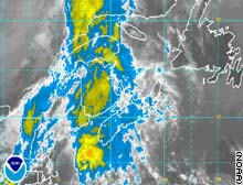
Tropical Storm Beryl
heads for Nova Scotia
• The northern edge of Beryl is beginning to affect the southern coast of Nova Scotia as well as New Brunswick. Forecasters are expecting the storm to dump over 50mm of rain in the area along with gusty winds. This is the second named storm of the young Atlantic Hurricane season, we had 5 at this time last season. The storm will rapidly lose its tropical nature as it moves northeast into the Atlantic Ocean.
• Beryl brushed across Eastern Massachusettses with rain and wind but nothing more than that last night.
• It was hot this week in Kemptville. I recorded a max temperatures of 36C on Monday. The official reading was 33C at the MNR building.
• Hydro workers in Ontario continue to restore power to the more than 100,000 customers that lost it from Lake Superior to the Quebec border on Monday. The thunderstorms lashed the area with 100km/h plus winds and heavy rain. Two tornadoes were reported in New Market and numerous trees, some as old as 100 years, were flattened on Manitoulin Island. One death was reported from Monday's storms in Ontario.
• Glasgow, Montana did not reach 90F on Wednesday marking the first day since July 4 that it failed to do that. It was the 5th longest stretch of 90 degree plus weather since records began. The area along with most of western Canada and the Pacific Northwest will remain under intense heat again this week with temperatures approaching 100F (37C) in many areas.
• The Kemptville "bubble" remained in place last night. While many areas continue to see thunderstorms, parts of the Highway 43 corridor from Merrickville to Kemptville continue to miss out. The storms part as they approach the area going north into Ottawa or south into New York State.
Monday, July 17, 2006
High heat - smog and humidity
The weather in the east has become extremely hot and humid. A smog warning is in effect for most of southern Ontario. Very poor air quality has also resulted in an Air Stagnation Advisory for the northern counties of New York State. A High Heat and Humidity Warning has been posted for southwest Quebec.
As of 4pm, Kemptville had reached 32C with a Humidex value in the dangerous range at 42C. Brockville had a reading of 43C to be the highest in the province. Montreal was at 32C. A Severe Thunderstorm Watch is now in effect for most of eastern Ontario. Heavy Thunderstorms are possible in the tropical air through tonight as a cold front presses east.
Monday, July 10, 2006

Friday, July 07, 2006

Hot weather returns
Big changes in the east are expected over the next several days as very warm humid air streaks into Ontario and Quebec. Temperatures will be from 27-30C right into next weekend. A few thunderstorms are expected as well. It has been a wild stretch of weather lately. Severe thunderstorms in Ontario this week caused flooding and toppled some trees. The Kemptville area was spared for the most part with the exception of a strong storm late Tuesday that brushed the area. The winds were strong enough to tear branches from some trees and the parting storm left a rainbow behind(above).
In addition to the storms in Ontario, two confirmed F-1 tornadoes were reported in New Brunswick. Today smoke from the forest fires in the northern Prairies and Rockies is drifting east into the eastern part of the country. Satellite images show the smoke stretching up and down the eastern coast.
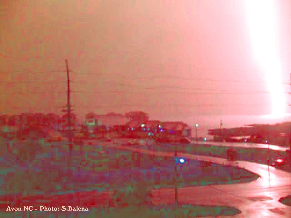
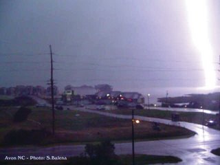
The photo below is one I took on Friday, May 26, 2006 on the Outer Banks of North Carolina. It is a lightning strike illuminating Pamlico Sound near Avon, North Carolina.
Subscribe to:
Posts (Atom)