Sunday, December 31, 2017

Extreme cold to last into the new year for Montreal


As year 38 draws to a close for me in the weather business, I want to thank you for reading. Weather has always been a huge part of my life since I started taking daily observations back in 1979. I am truly humbled to be able to share my passion with you. Happy New Year.

Extreme cold covers nearly two-thirds of North America on this New Years Eve, with widespread weather warnings in place from the Prairies to Atlantic Canada and into the deep southern US. Montreal is included in the cold warnings for the 5th consecutive day. On Saturday, we manged a high of -17.6C (1F), the first time in 87 hours Trudeau Airport was above -18C (0F). A new surge of arctic air arrives today, on gusty northwest winds up to 40km/h. We may make it to -19C (-2F) today. Tonight and New Years Day, the windchill will be brutal, approaching -40C. Expect mostly cloudy skies, with frigid conditions, perhaps a few flurries and a low -26C (-15F). We start 2018 cold on Monday, with a high of -22C (-8F), the night may be the coldest yet, with an overnight low of -27C (-17F) in Montreal, and -32C (-26F) in Ottawa. Temperatures will moderate slightly during the mid-week before more arctic air arrives by next Friday. With strong cold high pressure in place over the region, no major storms are on the horizon for southern Quebec.

With temperatures expected to hover near -18C (0F), and windchill values in the minus 30s, numerous outdoor New Years Eve celebrations have had to be cancelled or relocated in many cities. In Ottawa, the concert planned for the main stage to celebrate both the new year and Canada 150 has been cancelled. Organizers felt it was just too dangerous to hold the event in -25C weather. Many Canadians on social media disagree with the decision. Here in Montreal, it is business as usual, with no cancellations at this time in the Old Port of Montreal or other municipalities.

Friday, December 29, 2017

Arctic blast sweeps country

This is quite the cold snap in Montreal, challenging those of January 1957, Dec/Jan 1993-94 and Dec/Jan 1980-81. The coldest temperature ever recorded in Montreal, occurred on January 15, 1957, when the mercury bottomed out at -37.8C (-36F). This outbreak will not be as cold as those mentioned, but it will make up for that with its duration.


Crews continue to battle the bone-chilling cold, while cleaning up from the Christmas Day storm. (ValleyWX)
Frigid air continues to dominate the weather landscape across southern Canada, and into the northern two-thirds of the US. On Thursday, Montreal failed to crack the -20C mark after an icy overnight low of -27C (-17F), the coldest of 2017. At least the good news this morning, is the winds have eased, allowing for windchill values to fall to more manageable levels. At one point on Thursday morning, the windchill was -40C in Montreal. It was brutal outside. Along with the cold came the usual problems, frozen pipes, stalled cars and a slow transit system. Icy surfaces on bridges have caused a number of accidents since Boxing Day. With the cold came an increasing demand for battery boosts. On Wednesday alone, CAA-Quebec responded to nearly 8600 service calls. A fire in Verdun on Thursday was thought to have been started by someone using a blowtorch to thaw frozen pipes. No injuries were reported in the fire on Rusbrooke, but power was cut to 6000 Verdun residents. The six-unit building suffered severe damage, with the Red Cross providing temporary shelter for the occupants.
Someone thawing frozen pipes with a blowtorch may have started this 4-alarm fire in Verdun on Thursday. (CTV News)
The extreme cold warning remains in effect this morning, but temperatures will moderate slightly today, with some cloud cover and flurries forecast into Saturday. The high for Montreal today is expected to be -18C (0F), with an overnight low of -24C (-11F). On Saturday, expect a balmy high of -17C (2F). Any snowfall will result in a trace to 1cm or so through Saturday evening. On Sunday, a reinforcing shot of cold air will arrive on gusty northwest winds. Expect the temperature to remain below -20C (-4F) through New Years Eve and into Monday. Looking ahead, temperatures will warm slightly during the middle part of next week, but we may be looking at a significant snowfall on Thursday. The computer models are trying to nail down the track, stay tuned. Behind that system another surge of arctic air will arrive in Montreal to end the work week. January at this time is looking cold and snowy for the duration, sorry folks!

Tuesday, December 26, 2017

Dangerous cold from coast to coast to end 2017

Dangerous cold  is forecast, with windchill readings approaching -60C in parts of the country.

Cleaning up on L'Ile Perrot after 15cm of snow on Christmas Day. (ValleyWX Photo)
Another 10-20cm of snow fell across southern Quebec on Christmas Day, bringing the monthly total in Montreal to 60cm (2 feet). But this is nothing compared to the snow that has been piling up around the Great Lakes. In Erie, Pensylvania, from midnight to 6am Tuesday morning, 19 inches (48.2cm) of snow fell on the city. In less than 48 hours, 53 inches (134cm) has fallen and a whopping monthly total of 95.5" (235cm). That is roughly the average for Montreal for the entire season.

Over 134cm (53 inches) of lake effect snow fell on Erie, Pennsylvania in less than 48 hours. (Photo: Erie News Now)
In Montreal, arctic air is pouring into the area this Tuesday afternoon, on gusty northwest winds. At 2pm, Montreal was -13C (9F), with winds in excess of 50km/h and a windchill value of -23C (-9F). Blowing snow was also occurring making for slick highway travel outside the city. If you can believe it, that is likely the warmest temperature Montreal will see through Saturday. Dangerous cold has prompted extreme cold or windchill warnings from Alberta to Atlantic Canada. This morning, Fort Severn, Ontario was the coldest location in Canada at -45C (-49F), with a windchill of -55C (-67F). They are located almost 3800km from the North Pole. In Alberta temperatures hovered around -30C. In Saskatchewan, Val Marie in the deep southern part of the province near the Montana border, was -37C.

The forecast for southern Quebec calls for dry conditions but bitter cold through at least Friday. The overnight lows will range from -24C to -30C (-11F to -22F), with daytime highs struggling to get to -18C (0F). The coldest temperature I have recorded here at my home on L'Ile Perrot since we moved here in 2009, was -28.2C (-19F) on January 8, 2015. We will see if that reading is in jeopardy this week.

Sunday, December 24, 2017

New winter storm to impact Quebec & Ontario for Christmas Day

With another 8 to 10cm of fresh snow falling in Montreal on Saturday, we are guaranteed a white Christmas. More snow, wind and cold is on the way this week, and right into 2018. (ValleyWX Photo)
Another winter storm will take aim at southern Ontario, New York and Quebec, as well as the New England states over the next 24 hours. The storm, currently developing south of the lower Great Lakes, will move across the Ohio Valley and off the Maine Coast by Monday afternoon. The heaviest snow will fall south of the St Lawrence River and into Atlantic Canada.

Snow will spread across southern Ontario on Christmas Eve, with 10 to 15cm expected from Windsor to Kingston. The snow will arrive in Montreal overnight and taper off late Christmas Day. Accumulations in southern Quebec will range from 5 to 10cm north of Montreal, 10 to 15cm in the city and just south of the river, and 25 to 35cm for Sherbrooke, the Eastern Townships, and along the Maine border. Expect more snow in the lee of the Great Lakes, with totals of up to 50cm by Wednesday. Winds will become a factor with this storm, especially as the system strengthens along the Atlantic Coast. Expect widespread blowing snow along the St Lawrence River Valley, with wind gusts up to 50km/h in Montreal, and 70km/h in Quebec City.

Winter Storm Warning
A winter storm warning is in effect for the greater Toronto area, all regions south of the St Lawrence River and the Townships. A blowing snow advisory is in effect for Quebec City. Regardless of whether or not your area is under a warning, travel on all highways Christmas Day will be challenging. This is especially true on both Highway 20 and 40, Highway 401, and Interstates 81, 87, 89, 91 and 93. Travel today if you can or wait until Tuesday. Frigid air will surge into southern Quebec behind the storm with high temperatures only reaching -18C (0F) by Thursday. Lake effect snow will impact western New York and portions of Ontario through the week.

Saturday, December 23, 2017

Freezing rain, snow and arctic cold forecast in Montreal during the holidays

A Christmas day snowstorm is possible for many parts of Eastern Canada and New England. (AccuWeather.com)
Freezing Rain Warning in effect for southern Quebec.

Low pressure will move from the Ohio Valley across New England today. Snow mixed with freezing rain will start shortly in Montreal, lasting until at least midnight. The freezing rain should only be for a few hours in the Montreal metro region, with perhaps 2 to 5mm. More ice is expected southeast off Montreal where up to 10mm is possible locally. Snow will accumulate 5 to 10cm along the St. Lawrence Valley and points north of the region. Temperatures will rise today to around -5C (23F) in Montreal, and this will likely be the warmest temperature we see for the next two weeks.

Sunday will be the best travel day, with sunshine forecast, light winds, and high temperatures around -6C (21F). On Christmas Day, developing low pressure along the Atlantic Coast, will push snow across New England and into extreme southern Quebec and eastern Ontario. The snow will fall most of the day, with 10 to 15cm possible. Behind the storm, arctic air, the coldest in several years, will pour into southern Quebec. Daytime highs by Wednesday will struggle to reach -18C (0F), with overnight lows between -26 and -30C (-15 to -22F) in many parts of southern Quebec.

Thursday, December 21, 2017

Winter Solstice arrives with cold, snow and ice in the forecast for Montreal

Traffic in Montreal has been brutal this week, with long commute times, numerous accidents and several road closures. More snowy weather is expected on Friday, with and increasing threat for freezing rain Saturday. (ValleyWX)
Winter officially arrived at 11:28AM Thursday morning in Montreal. Today we are being treated to the least amount of daylight all year long, with only 8 hours and 42 minutes. The good news is that we will enjoy bright sunshine all day. Additionally the amount of daylight will slowly increase as we move forward towards spring and summer. The bad news is, temperatures are cold, and we have lots of winter weather ahead of us over the next few months, starting with the near-term forecast.

Difficult travel conditions expected
Thursday will be sunny and cold, with temperatures hovering around -10C (14F). Overnight, clouds will thicken up in response to a very slow moving warm front and developing low pressure system moving east form the Great Lakes. The temperature will slowly warm up as well into Friday adding to what may be a difficult forecast. On Friday snow will develop by mid-morning in southern Quebec and continue into the evening hours. At this time, Montreal can expect 5 to 10cm through midnight, with more expected south of the city. As the low pressure moves down the St. Lawrence Valley on Saturday, more precipitation will develop. The temperature will warm Saturday and will be critical in determining the type of precipitation we receive. The precipitation will re-develop on Saturday, as snow mixed with freezing rain. Amounts may be significant and warnings will likely be needed for a portion of the region. Travel will be impacted across Ontario and Quebec as well as New England and the Northeast US. This is a very busy travel period, so listen carefully to future forecasts and updated warnings. Sunday is expected to be the best travel day, with clearing skies and cold temperatures.

On Christmas Day, yet another low pressure area is expected to move along the east coast. Depending which forecast model you prefer, we are either in for a snowstorm or just a few flurries. One thing is certain, the weather will turn frigid next week through the final weekend of 2017.

Monday, December 18, 2017

Unsettled holiday forecast for southern Quebec

A frozen landscape as sea smoke rises off the St. Lawrence River in Vaudreuil Dorion Sunday morning. The air temperature at the time was -21C (-6F). Milder weather will arrive for a short period this week, before arctic air returns for the holidays. (ValleyWeather Photo)
This will be a busy travel week for many as the Christmas holiday rapidly approaches. Unfortunately, the weather is not going to cooperate with several systems expected to impact the region, along with some dramatic temperature swings. Arctic air is starting to move back into western Canada. This airmass is expected to dive into the deep southern US this week, while at the same time warm air surges north along the eastern seaboard. In between the duelling air masses will be the storm track.

Freezing Rain Possible
A warm front is expected to lift north into our region Monday, with light snow and some freezing rain possible into Tuesday. Accumulations will be light with up to 5cm of snow and perhaps a few millimetres of ice here in Montreal. Eventually the warm air will win out on Tuesday, with the mercury edging above the freezing point to 3C (38F). This warmth will be short-lived, with a sharp cold front arriving on Tuesday night. Temperatures will drop into the lower minus teens by Thursday morning, and remain there into Friday. On Friday, the weather will become quite active once again, with a strong storm developing in western Canada and moving towards Colorado, before moving across the Great Lakes. Several scenarios are in play here, with the exact storm track determining the type and quantity of precipitation. This will not be an easy forecast, but right now we are looking at snow Friday, changing to freezing rain late in the day and perhaps to rain Saturday. The entire mess will freeze up on Christmas Eve day as the arctic air surges back into southern Quebec. To say the least, this type of weather will greatly impact travel across Ontario, Quebec and New England. If you have any travel plans, pay close attention to future forecasts and any warnings as the week progresses.

Thursday, December 14, 2017

Frigid cold settles into Montreal behind the snow

The clean-up from the first snowstorm of the season started in most municipalities last night. The crew shown above was removing snow in Pointe Claire this morning. (ValleyWX)
The first snowstorm of the season for Montreal and southern Quebec is in the record books. The metro region received 20 to 25cm (8 to 10 inches) of snow along with gusty winds up to 60km/h. As the snow tapered off on Wednesday, the wind and cold took over, with snow drifting across area highways. The temperature fell to -19C (-2F) this morning and has been rather slow to rise to the current reading of -15C (5F) at 2pm. Windchill readings have been in the lower -20s all day.

It was a long, difficult day for most commuters on Tuesday. Heavy snow, a lack of plowing, and not enough snow tires, created long delays on Montreal roads. (CBC)
The storm resulted in a snarling commute on both Tuesday and Wednesday mornings, as motorists struggled to adjust to the highly changeable road conditions. Numerous major accidents were reported across the southwest portion of the province. Highway 20 near Coteau-du-Lac was closed for a period early Tuesday due to accidents and cars in the ditch. Skies cleared on Thursday, but it remained frigid. The cold air will persist through the weekend, before moderating slightly next week. A few weak weather systems will bring some light snow late Friday and again Sunday night into Monday. Up to 10cm may be added to the current snow on the ground by Monday evening. Mild air will briefly move into the region next Tuesday, with a high near 0C (32F) forecast. The milder weather will be short-lived, with more cold air and snow arriving late next week. It looks like a cold and snowy holiday period across southern Quebec at this time.

Tuesday, December 12, 2017

First snowstorm snarls Montreal traffic - 20cm forecast

It was a slow morning commute in Montreal, as the first snowstorm of the year impacted southern Quebec. (ValleyWeather)
Snowfall warnings remain in effect for southern Quebec today. Expect 15 to 20cm for Montreal, with up to 30cm in Quebec City. Winds will increase today up to 60km/h, backing to the northwest tonight and increasing to 70km/h. Widespread blowing snow will be a problem.

Another winter, same old story in Montreal. For some reason many motorists and several municipalities seemed caught off guard by the morning snow. Despite predictions for this storm days ago, it was a two hour plus morning commute for many. Lack of plowing and salting on Montreal hills and highways, combined with an absence of snow tires on many cars, slowed traffic to a crawl. The evening drive will be just a challenging. The deadline to have your winter tires installed is this Friday, December 15. By next season, the date will be moved froward to December 1st, much better for all of us.

Low pressure will move from the Ohio Valley across central New England today while strengthening. Snow started in Montreal at around 4am, with close to 10cm on the ground as of 10am. Temperatures are cold and will remain that way into this weekend. The high today may reach -5C, but will drop tonight down to -12C and remain there on Wednesday.

Friday, December 08, 2017

Arctic air - measurable snow on the way for Montreal

There is more snow this morning in Texas than in Montreal. Heavy wet snow fell in places across the deep south Thursday night, including at Kyle Field in College Station, Texas, the home of Texas A&M. College Station is located about 150km northwest of Houston, where light snow also fell. (Photo via Twitter @AggieFootball)
There is more snow in south Texas this morning than in southern Quebec. That being said, arctic cold and snow are on the immediate horizon for Montreal. Friday morning, the first cold front stretches from the Gulf of Mexico to Atlantic Canada. Along it snow is falling, in places where is should not be. Winter storm warnings stretch from the Mexican border into North Carolina. Further north, the cold air is sweeping across the wide open and considerably warmer Great Lakes. The result is heavy lake effect snows in several regions. Some of the narrow lake bands are moving northeast along the St. Lawrence Valley, affecting the 401 corridor from Kingston to Cornwall. A few of the snow showers have even made it into southern Quebec, with a fluffy centimetre or two falling last night on L'Ile Perrot. More snow showers are possible later today in Montreal.

On Saturday, low pressure will move up the east coast, producing a swath of 10 to 15cm snowfall from interior New England towards the Gaspe Peninsula. At the same time, a clipper system will also approach Montreal from the west, with a light snowfall Saturday night, followed by much colder air. Next week will future several opportunities for light snowfall, along with very cold temperatures. Daytime highs on Sunday will be around -2C (29F). By Tuesday through Friday, the high will only be around -10C (14F) in Montreal. Several systems will also produce light snow next week. The timing and amounts will need to be fined tuned, but a good 10 to 15cm of snow could be on the ground by next Friday. Winter has arrived!

Wednesday, December 06, 2017

The Halifax Explosion 100th Annivesary


Thursday, December 6, 1917, 9:04:35 AST
Halifax was booming in 1917, an extremely busy port city of 50,000. Ship traffic was heavy, especially due to the outbreak of World War I. Then, just past 9:04am on December 6, 1917, disaster struck. Read more about it HERE

Monday, December 04, 2017

Major pattern change on the way for eastern Canada

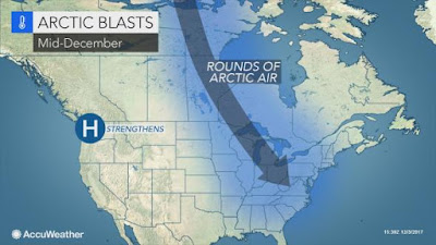
The pattern of alternating warm and cold weather that has been around most of this fall, will come to an end this week. An arctic front will bring in much colder air, that is expected to remain in Ontario and Quebec through December. (AccuWeather.com)
11:45 UPDATE: Winter Storm Watch has been hoisted for western New York counties for Lake Effect snow by Wednesday.

Environment Canada has issued a wind warning for the Richelieu Valley for late tonight and early Tuesday. Expect south winds gusting up to 90km/h.

The mild weather is about to come to an end, and won't likely return until May. No, but seriously, Arctic air is set to invade the Great Lakes over the next 48 hours, sliding into eastern Canada by the weekend. The catalyst will be a major winter storm developing over Colorado, and moving northward toward Lake Superior. Montreal, southern Ontario and Quebec will be on the warm side of the system, with a surge of mild air through Wednesday. Closer to the center of the storm, heavy rain is forecast from Michigan into central Ontario. West of the storm track, blizzard conditions are expected from the Dakotas into extreme southeast Manitoba and northwest Ontario. Forecasters are calling for 30 to 40cm of wind driven snow in some regions, along with dropping temperatures. Travel is not advised tonight and Tuesday across portions of the Dakotas, Minnesota and northwest Ontario.

In Montreal, sunshine on Monday will fade away as clouds increase. Tuesday will be cloudy and very mild, with high temperatures soaring to 9C (48F). Winds will increase tonight, becoming quite strong in the afternoon, gusting up to 60km/h. A cold front, the leading edge of the arctic air, will sweep across the area on Tuesday night into Wednesday, with gusty winds, rain and dropping temperatures. The balance of the week will be much colder, with the chance of flurries through Saturday. Temperatures are forecast to become increasingly colder as we head into the weekend. Daytime highs will struggle to reach 0C (32F) by Friday. At this time, it looks like the balance of the month will remain below freezing in southern Quebec, with frequent chances for accumulating snow. Next week, daytime high temperatures will be no better than -3C (27F). The details will become clearer as time moves along, but expect much colder weather starting late this week.

Wednesday, November 29, 2017

Enjoy the mild weather, winter set to return

Toronto quarterback Ricky Ray, shown above, along with his teammates, the Calgary Stampeders and fans, battled steady snow Sunday night during the 105th Grey Cup in Ottawa. (TSN)
Despite the quick 5cm of snow that fell on the 105th Grey Cup Sunday in Ottawa, and across southern Quebec, it has been a mild week once again. In keeping with the last blog entry, the temperature roller coaster ride continues. There was no better example of this than the snow and biting cold Sunday and early Monday, followed by windy and warm weather Tuesday. On Tuesday, Toronto reached 17.1C (63F), Ottawa 11C (52F), remarkably after an early morning low of -13.7C (8F), and Montreal 6C (43F), after a low of -11.7C (10F). A series of weak weather systems will keep the temperature bouncing around through the first week of December. Expect the weather to remain fairly mundane in Montreal, with more clouds than sun and temperatures well above normal.

Cold weather is forecast to return to eastern Canada by December 10th. (AccuWeather)
Cold Weather Returns
There are strong indications that we will see a major pattern change by December 10th or so. Expect much colder air to return, and last through Christmas, along with frequent opportunities for measurable snow. The jet stream is expected to become more amplified, allowing storms to move slower, gain strength and gather moisture from the Gulf of Mexico and Atlantic Ocean. The exact details are hard to pinpoint at this time, but temperatures will return to normal levels and eventually below normal in Montreal. This would put daytime highs well below freezing. There is a good chance of a snowstorm around the 11th of December and again near Christmas. The cold weather is expected to stay with us right through the end of December.

Saturday, November 25, 2017

Weather whiplash in southern Quebec

The first snow of the season in Vaudreuil last weekend, did not last long, as warm air returned by mid-week. (ValleyWX)
After a record breaking warm October in Ontario and Quebec, November is proving to be anything but certain. If you are not sure which jacket to grab in the morning, you are not alone. The change in temperature from day to day is enough to give you whiplash. With a predominate west to east "zonal" flow in place across Canada, weather systems have been moving rather quickly, producing highly variable weather. On Sunday, November 19, Montreal recorded the first measurable snowfall of the season, with anywhere from 2-5cm falling. Monday was windy and bitter cold, with snow flurries and temperatures at -6C (21F), windchill values were as cold as -18C (0F) However, just 24 hours later the temperature was 8C (48F), with bright sunshine. This pretty much describes the month we have had in Montreal, from mid-winter cold, to near record-breaking warmth and back again, at times in just a few hours.

That brings us to this weekend, where pretty much the same pattern is in place. The current weather is being produced by a potent cold front slipping across the St. Lawrence Valley. A steady rain in Montreal, will slowly taper to a few flurries tonight. Gusty west winds will increase up to 50km/h this evening. Temperatures in southern Quebec today are in the 5 to 10C (40 to 50F) range. Behind the front, cold air will surge into the region, with lows down to -4C (26F) by Sunday morning. Sunday will be windy and cold, with flurries and temperatures remaining steady. Yet another clipper system will arrive late Sunday into Monday, with some light snow and chilly temperatures. However, the cold will not last long. By Tuesday, more mild air will surge into the region, with temperatures well above normal expected for most of the upcoming week. As long as this flat, zonal pattern remains in place, the arctic air will remain trapped across the far north, with any storm systems being rather weak and moisture starved. I expect a change by the second week of December.

Saturday, November 18, 2017

Freezing rain warning for southern Quebec

Freezing rain warnings are in place for southern Quebec this afternoon and tonight.
Strengthening low pressure will rapidly move from the central plains into the Great Lakes tonight, and down the St. Lawrence Valley on Sunday. Waves of precipitation are expected over the next 24 to 36 hours from southern Ontario into Quebec. Along the path of the storm, mixed precipitation is forecast. North and west of the system, snow will be the dominate precipitation, with as much as 25cm expected in the Laurentians and upper Ottawa Valley. South of the track towards the US border and in the Townships, look for mostly rain.

Freezing Rain Warning
Environment Canada has a wide range of warnings in effect for this afternoon and especially overnight. In Montreal, a freezing rain warning has been posted. A mix of snow and rain this afternoon, will transition to rain tonight as the temperature rises from -2C (28F) up to 4C (39F) by morning. Expect between 2-4mm of ice in Montreal. North of the city and in Ottawa, the freezing rain will last longer, with as much as 15mm possible. In Ottawa, the rain will change back to snow overnight, with as much as 10cm before it ends on Sunday. As the storm moves east of Montreal on Sunday, a strong cold front will sweep the region. Cold air will surge back into Ontario and southern Quebec, with any mixed precipitation changing back to all snow and ending in the afternoon. A couple of centimeters of snow are possible in the St. Lawrence Valley Sunday. Temperatures will fall back below freezing by noon on Sunday. Strong winds will also develop on Sunday, gusting up to 60km/h across the entire area. Travel will be highly variable and quite dangerous at times this weekend. Expect icy patches in the city. North and west of Montreal, conditions will quickly deteriorate, with lowering visibility and snow covered roads. The weather will improve on Monday.

Thursday, November 16, 2017

Strong weekend storm to bring rain and snow to Quebec

Cold air will follow the weekend storm into eastern Canada and the US. Expect temperatures to be well below normal, along with lake effect snow and snowshowers. (AccuWeather.com)
A strong fall storm is forecast to develop over the Midwest US on Friday, moving across the Great Lakes and eventually down the St. Lawrence Valley this weekend. The strengthening storm is expected to bring a messy mix of rain and snow to eastern Ontario and southern Quebec. Precipitation is expected to start Saturday in Montreal, in the form of wet snow, likely mixing with and changing to rain in the city. A heavy wet snow mixed at times with freezing rain is forecast at this time north of Montreal into the lower Laurentians, as well as in the Ottawa Valley.

As much as 20cm of snow is possible north of Montreal. At this time, the forecast track of the storm is not set in stone. A change of a few kilometres will mean the difference between snow or rain for several locations. Temperatures will be cold on Friday in Montreal, warming slightly Saturday to above freezing, before cooling off Sunday. Strong winds and dropping temperatures are expected in the wake of the storm on Sunday. Winds are expected to be above 50km/h Sunday. The temperature will remain below normal next week along with the chance for some light snow or flurries.

Monday, November 13, 2017

Record cold weekend - can the snow be far behind

The first cold air of the season blasted into southern Quebec last weekend. Some locations in Quebec and Ontario recorded their first measurable snow as well. Montreal only had a trace, but more is on the way, soon.  
Temperatures across southern Quebec are slowly moderating to start the work week, after record cold Friday and Saturday. Friday was an absolute shock to the system, as a record low temperature of -8.9C (16F) in Montreal, combined with howling winds over 50km/h, to produce mid-January like windchill values. After the warm fall we have had, it was a wake up call. More cold occurred Saturday, with a record low of -9.7C (14.5F), the old record low was -8.3C (17F) set in 1973. Those temperatures were at Trudeau Airport on the island, it was much colder in the suburbs. On Saturday, the mercury remained below freezing all day with a high of -1.3C. Thankfully the wind slowly diminished for Remembrance Day services. Some snow accompanied the cold air, with a trace to 1cm in Montreal. There were some icy spots on Friday, but roads were mostly clear in the city. The cold and threat of snow had motorists scrambling to get their winter tires on. The deadline in Quebec is December 15, but that is laughable at best. Trust me when I tell you, we will have significant snow before then, guaranteed.

Saturday was beautiful, but cold. The chilly St Lawrence Seaway looking south into New York State at  Johnstown, Ontario. (ValleyWX)
First Measurable Snow
With the arrival of the first arctic air of the season, and the ground now partially frozen, the first measurable snow can't be too far behind. A clipper-type low will arrive late Wednesday into Thursday, with a light rain and snow mix. Any accumulations will be confined to the higher elevations and points north of Montreal. Behind this weak system, cooler air will filter back into the region for Friday. By next weekend, a much stronger storm will approach from the southwest, once again look for a mix changing to a cold rain in Montreal. This storm has the potential to produce measurable snow in some locations, along with gusty winds. By Sunday, cooler air returns, with any precipitation changing back to flurries. At this time, next week looks colder than normal, with the chance for more snow by mid-week.

Wednesday, November 08, 2017

First arctic blast of the season for southern Quebec

A strong arctic cold front will precede the coldest air of the season in southern Quebec. Some light snow and a rapid freeze is expected late Thursday night in Montreal. (AccuWeather.com)
The first shot of polar air this fall season is forecast to invade southern Quebec late Thursday and Friday. Expect gusty winds, some snow and ice and a hard freeze by Friday morning. Arctic air has taken up residence in western Canada, with temperatures in the minus teens. A portion of the same airmass will arrive behind a potent cold front late Thursday. The front should cross southern Quebec shortly after midnight early Friday morning. Temperatures will rise to around 8C (48F) on Thursday, along with an increase in clouds. 

Frigid Friday
The arctic boundary that will cross the Great Lakes and southern Quebec late Thursday, will be accompanied by gusty winds and periods of rain changing to our first snow of the season. In Montreal a dusting to 1cm may fall, along with plummeting temperatures. Some higher elevations of Quebec and New England can expect as much as 5cm. Locations near the Great Lakes and across northwest Quebec may receive even heavier amounts. By Friday morning, the temperature in the city will be at a bone-chilling -11C (12F). This will come as quite the shock to the system after the extremely warm fall we have experienced. Friday will be windy and frigid, with high temperatures no better than -5C (23F). Gusty winds in excess of 50km/h will produce windchill readings near -18C (0F). Temperatures will moderate closer to normal levels as we head into the weekend. Saturday looks sunny at this time, with perhaps a few flurries or showers on Sunday. The average high/low for this time of year in Montreal should be plus 7C (45F) and -1C (30F) respectively.

Friday, November 03, 2017

Canada’s new weather supercomputers will improve forecasts and warnings

I had the absolute privilege of meeting the current President of the World Meteorological Organization and Assistant Deputy Minister for the Meteorological Service of Canada, David Grimes, in Dorval on Thursday. (Photo: Robert Frank)
Canada has moved to the forefront of weather computer modeling with the delivery of two High Performance Computers (HPC) from Shared Services Canada (SSC) and IBM. These high-performance computers were officially dedicated at a service at the Canadian Meteorological Centre in Dorval on Thursday, November 2. Minister of Public Service and Procurement, Carla Qualtrough was on hand for the unveiling. But, as a weather nerd, it was Assistant Deputy Minister for the Meteorological Service of Canada and current President of the World Meteorological Organization, David Grimes, who caught my attention. It was an absolute honour to talk to him about the new computers and weather in general. A video presentation of last weekend’s intense storm, as displayed by the new supercomputer modeling output, was beyond impressive. According to Grimes, these computers will make Canada, “one of the best modeling centers in the world”. “Our early-warning system has been greatly enhanced,” he added. The new HPC solution is the fastest recorded computer platform within the Government of Canada, and among the fastest in the world. 

The super computers will allow for complex weather programs and models, involving over 10 billion data points, to be processed much quicker. The end result for Canadians will be more accurate and timely forecasts and warnings. What was exciting for me to discover was that my Davis Vantage Vu weather station, in my backyard on L’Ile Perrot, is likely one of those data points. Information is pumped into these computers from all around the country and the world. Weather knows no boundaries. If you are processing weather data and uploading it to the web, it will likely be used in one calculation or another.

Computer weather modeling has become crucial in recent years.  It allows forecasters to input current weather data, along with additional information, variables and parameters, to basically map out how weather systems will move in both the short and long-term. According to Grimes, a typical model run can take around seven hours, but that will gradually be reduced over the next decade, down to almost real time within ten years.

The HPC is five times faster than the old Environment and Climate Change Canada (ECCC) computers, processing data at an astonishing 2.444 trillion calculations per second. The HPC is primarily for ECCC weather predictions, but additional organizations will also benefit from this resource. Health Canada for air quality alerts, Fisheries and Oceans Canada to support ocean modeling and Public Safety Canada to support environmental emergency prevention – just to name a few. Today’s new supercomputers are 70 million times faster than Environment Canada’s first supercomputer purchased in 1974.


The new ECCC supercomputers were dedicated to; Kenneth Hare above, and Harriet Brooks below.
(ECCC Photo)
The new supercomputers were named for two late distinguished Canadian scientists: Harriet Brooks, Canada’s first female nuclear physicist, who worked with Marie Curie and contributed to research on radon gas, and Kenneth Hare, Canadian environmental science advocate, who warned about carbon-driven climate change long before many others were paying attention.


Tuesday, October 31, 2017

Widespread damage across Quebec in the wake of storm

A deep coastal storm produced damaging winds across southern Quebec on Monday, including the Eastern Townships shown above. (Photo: Sandra Thomson) 
The storm is over but the scars remain. Montreal was rather fortunate, as the worst of the powerful coastal storm seemed to split the city. Deep low pressure moved just west of Montreal, producing near record low barometric pressure (976mb) and winds up to 80km/h. We were lucky ones. Other regions had winds in excess of 100km/h, combined with torrential rains and flooding.

In the wake of the storm, nearly 1.5 million customers were without power in New England, Quebec and Ontario. As of 11am Tuesday, 40,000 Hydro Quebec customers were still without power across the province. The utility has over 700 personnel on the job. The storm also took down thousands of trees, many onto homes and cars. Peak wind gusts over the last 36 hours included, 214km/h (133mph) on Mount Washington, New Hampshire, 101km/h (63mph) at Burlington, Vermont, 109km/h (68mph) at Port Menier, Quebec, 87km/h (54mph) at Saint Hubert and 80km/h (49mph) at Trudeau Airport in Montreal. Warm air circulated along the east side of the low pressure, with 28 record highs reported in Quebec on Monday. Thunderstorms even rattled across Quebec City producing additional heavy rain and wind damage.

Hydro Quebec has 700 workers on the job, after strong winds knocked power out to over 200,000 Quebec homes. Above a crew works in Knowlton, Quebec. (Knowlton.com)
West of the storm track, extremely heavy rain fell. Flooding occurred in Ottawa/Gatineau, where 112mm of rain fell in less than 48 hours. Today a flood watch remains in effect across the Rideau Valley. Major flooding was also reported in New Hampshire, where numerous rivers overflowed their banks, sweeping away roads and in some cases entire homes.

Cold air has settled into southern Quebec for Halloween. Gusty west winds will continue today, diminishing towards sunset. Temperatures will be near 4C (39F) for trick or treating. Indications are that the cool weather and perhaps even flurries or light snow will occur during the first week of November. Now might be the time to get those snow tires on.

Monday, October 30, 2017

Damaging winds for Montreal

NOAA water vapor image of powerful low pressure moving north up the Hudson Valley, (dry slot in the middle of the image) towards Montreal this morning.
A high wind warning remains in effect for the entire region this morning. Winds have been gusting in excess of 100km/h across the Eastern Townships into Vermont overnight. In Montreal, gusts have been up to 60km/h, but they will increase towards 90km/h this morning. Deep low pressure will move north from the Hudson Valley towards Massena, New York today and into western Quebec tonight. Extremely low barometric pressure readings have been occurring across our area, with 977mb here at my home on L'Ile Perrot and 972mb at Ottawa. This represents the lowest pressure of the year for L'Ile Perrot. Also, the pressure has fallen 20mb since midnight, indicating just how strong this storm is. Southeast winds and a dry slot cut off precipitation here in Montreal overnight, with 25 to 30mm recorded. On the cold side of the storm in Ottawa, heavy rain fell all night, with in excess of 50mm falling. The weather is also very warm in Montreal this morning. With a temperature of 19C (66F) at 6am, Montreal is the warmest location in the country.

Storm damage in New England overnight. (NBCCT)
The wind has caused widespread damage and power outages across New England and Quebec. In Quebec, Hydro is reporting 157,000 customers without power as of 7am. That number will only grow as the strongest winds move into metro Montreal.

As the storm moves north of Montreal today, winds will shift to the southwest and west and eventually diminish a little by evening. Temperatures will also drop rapidly today back into the single digits. Showers, some heavy are expected through early afternoon.

Sunday, October 29, 2017

Heavy rain warning for Montreal & Eastern Ontario

Strong damaging wins are forecast for Montreal and the St. Lawrence Valley on Monday. (AccuWeather.com)
11:00 AM Sunday Storm Update:
Low pressure, a combination of a developing coastal storm along with input from Tropical Storm Philippe, is forecast to move northward along the east coast today. By Monday, the strong fall storm will be very close to Montreal. Rain has developed today well in advance of the system and will increase in coverage an intensity tonight. A heavy rain warning has been issued by Environment Canada for Montreal and most of southern Quebec. The warnings extend into Ontario and New York. Forecast rain amounts for the next 24 hours are quite impressive, with 50 to 100mm (2 to 4 inches) expected from Montreal west towards Kingston and south into upstate New York. In addition to the heavy rain, strong winds are forecast late today and Monday. The winds will increase out of the southeast up to 100km/h (60mph) late today from central New England towards the Eastern Townships. On Monday the area of strongest winds will be the St. Lawrence Valley and eastern Ontario, where gust will approach 90km/h (55mph), including here in Montreal. Some flooding is possible from the heavy rain, but I think the real concern with this storm for Montreal will be the strong winds on Monday. Expect tree damage and power outages here in southern Quebec.

Please note, when following weather on this site or any site for that matter, always verify the time the warnings were issued. Keep in mind, that for safety reasons, only Environment Canada or the National Weather Service stateside, have the authority to issue official weather warnings. Stay weather savvy my friends, and most importantly be safe.

Saturday, October 28, 2017

Potent pre-Halloween storm for southern Quebec & Ontario

AccuWeather.com
High impact weather event expected for southern Quebec and eastern Ontario Sunday and Monday.

Computer models continue to indicate that strong low pressure will impact our region starting late tonight through late Monday. In the meantime, we have the calm before the storm in Montreal, with a perfect late October day. The 2pm temperature at Trudeau Airport is 18C (65F), with abundant sunshine. Behind a potent cold front, Toronto sits at 7C (45F).

The aforementioned front will become the focus for very heavy rain on Sunday. As the front advances eastward, low pressure will develop along the east coast and ride northward along it towards Lake Champlain. This storm is expected to strengthen rapidly, producing a widespread, high impact weather event. Heavy rain will fall along and west of the storm track. At this time, the heaviest rain, up to 100mm (4 inches), is expected from Watertown and Kingston northeast towards Ottawa. Here in Montreal 40-60mm is likely. Another component of the storm will be strong winds. The winds will develop late Sunday from the southeast up to 60km/h, backing to the northwest Monday and increasing up to 100km/h. Winds of this strength can bring down trees and produce power outages.

With all the leaves on the ground and those likely to be stripped form the trees, urban flooding is a real concern. Expect travel delays across the entire region late Sunday and Monday. In New England and eastern Quebec, coastal flooding will also be a concern. The storm should move out of the region by early Tuesday. The weather will turn much colder behind the storm, with showers and perhaps a few flurries on Halloween day.

As of 3pm, a flood watch is in effect for the US side of the St. Lawrence Valley, along with a high wind watch. At this time, special weather statements are highlighting the storm on the Canadian side of the border. I expect official warnings will be issued at some point later today. I will update these as they happen.

Friday, October 27, 2017

Strong fall storm to impact southern Quebec

A strengthening coastal storm is forecast to bring heavy rain and strong winds to southern Quebec on Sunday and Monday. (AccuWeather.com)
Cooler weather has settled into southern Quebec to end the work week. As we head into the last weekend of October, big changes are on the horizon. Saturday will be partly cloudy and relatively mild, with daytime highs near 15C (59F). Late Saturday and early Sunday, low pressure will move east from the Great Lakes into Quebec, with showers. This is the same system that spread snow across the upper midwest, southern Manitoba and northwest Ontario. Montreal however will remain on the mild side of this system, with all liquid precipitation. On Sunday, a rapidly strengthening coastal storm will move northward from Florida to the Carolinas, and eventually into New England by early Monday. This storm has the potential to produce very heavy rain across the region, along with strong winds.

The heavy rain is expected to fall during a 12 to 18 hour period Sunday into early Monday, with between 50 and 100mm (2-4 inches) possible. In addition to the rain, gusty winds of up to 80km/h are possible as well. Some localized flooding is likely, along with the potential for power outages. A special weather statement has been issued by Environment Canada. This may be upgraded to a weather warning as the weekend progresses and the forecast becomes more certain.

The Halloween forecast looks cloudy and cold but thankfully dry.
Behind the storm, much colder air will be drawn south, with a chance for some flurries in the higher elevations by Halloween. The good news for trick or treaters is that the weather should improve by Tuesday. Conditions will be cloud but dry, it will however be much cooler, with daytime highs near 6C (43F).

Monday, October 23, 2017

Cooler fall weather forecast to return to Montreal

Much cooler, wet weather is on tap for Montreal as the week progresses. (AccuWeather)
The weather in Montreal this October has been nothing short of spectacular. To date, including Monday, Montreal has recorded 9 days where the temperature has been 21C (70F) or higher. Normally, we have none. The average high temperature between October 1 and 22 was 18.9C (66F), the long-term average for this period should be 13C (55F). The overnight lows have been mild as well, with an average low of 8.6C (48F). The normal low should be 4C (39F). Our peak temperature so far this month was 25.8C (79F). On Monday, the warm weather continued, with a high of 22C (72F) at Trudeau Airport, shy of the daily record of 25C (77F) set in 1979, and well above the normal of 11C (52F). St Anicet, southwest of Montreal, was the warmest location in Canada on Monday, reaching a record-breaking 25C (77F).

There are major changes in the near future. The high pressure responsible for the perfect weekend weather will move off the east coast tonight. In its wake, a low pressure area and cold front will slide across the Great Lakes into southern Quebec on Tuesday. A period of showers and isolated thunderstorms is forecast Tuesday into early Wednesday morning. The rain may be heavy at times, with 25mm (1 inch) expected in Montreal, but as much as 50mm (2 inches) southeast of the city towards Sherbrooke and the US border. Gusty southerly winds up to 60km/h are forecast to accompany the rain on Tuesday. The temperature will be mild once again, reaching 21C (70F) before the frontal passage. Once the front clears the area, cooler air will settle into southern Quebec. The weather will not be frigid, just closer to what is should be for late October. The forecast high on Thursday is expected to be 13C (55F). Temperatures will moderate slightly into the weekend, with the chance of showers, before even colder air arrives to start next week.

Halloween & Beyond
At this time, the Halloween forecast looks cloudy and cooler, but dry in Montreal, with a daytime high of 9C (48F). Expect trick or treating temperatures of around 5C (41F). Looking ahead to the first week of November, single digit daytime high temperatures are expected at this time, along with perhaps a few showers or even some snowflakes. Frost is likely on numerous nights to start November, as temperatures drop below normal for the first time in weeks.

Wednesday, October 18, 2017

Record breaking Prairie windstorm - more warm weather for Montreal

The first frost of the season occurred on L'Ile Perrot early Tuesday morning. Our weather will turn unseasonably warm once again as we head into the upcoming weekend. (ValleyWeather Photo)
Another period of warm and dry weather is expected across much of southern Ontario and Quebec this week. Temperatures will go above normal in Montreal on Wednesday and remain that way right through the upcoming weekend. The average high/low for mid-October in Montreal is 3C/12C. Temperatures will be well above this, with daytime highs approaching 21C (70F) by Saturday. Overnight lows during this period will be between 7C and 13C (45 to 55F). Coming after our first official frost, which occurred on Tuesday morning, this could be considered our Indian Summer. Big changes are on the horizon for Montreal, as a potent cold front and upper level low pressure area will begin impacting our weather early next week. Showers, strong winds and much colder temperatures are expected by the end of next week, into Halloween.

Above and below: Wind speeds of up to 131km/h in Moose Jaw, 119km/h in Regina and 113km/h in Saskatoon, generated widespread damage on the prairies. (CBC Photo)
Prairie Windstorm
A fast moving low pressure and cold front swept across Alberta and Saskatchewan on Tuesday creating hurricane force wind gusts. Winds in excess of 100km/h knocked down trees and power lines, fanned grass and brush fires and took down hundreds of trees. In Alberta, the highest wind reported was at Acadia Valley at 126km/h. Meanwhile a gust to 131km/h occurred at 10pm in Moose Jaw. This was the strongest wind ever recorded in that city, the previous record was 119km/h set on October 16, 1991. The wind caused widespread damage to several homes and businesses. SaskPower reported multiple outages across the province, impacting thousands of customers.

In southwest Saskatchewan, a rapidly moving grass fire forced the evacuation of Leader, Burstall and the RM of Deerfork. Residents were allowed to return home Tuesday evening. The windy weather was being blamed for the derailment of 28 rail cars, blown off the tracks near Huxley, Alberta. The wind also blew dust and debris across the Trans-Canada Highway, making travel extremely dangerous from Calgary to Regina. In addition to the wind, 13 new record high temperatures were established in Saskatchewan on Tuesday. The strong winds have now moved east into Manitoba.


Monday, October 16, 2017

From record warmth to frost

Wind damage to homes in Mount-Laurier, north of Montreal. (Photo from Jason Campbell via CBC)
This weather this October could very well give you whiplash. A frost advisory is out for Montreal, just 24 hours after record warmth in southern Quebec. The first widespread frost of the season is likely Monday night in Montreal, with overnight lows between 0C and -2C (29 to 32F). On Sunday, strong low pressure over the Great Lakes, combined with a potent cold front to produce very strong winds and record warmth. Saint-Anne-de-Bellevue reached 24.6C (76F), eclipsing the old record of 23.3C (73F) set in 2014. Saint Clothilde near the US border was 25.7C (78F), also breaking the 2014 record of 23.8C. The warm spot in the entire country was Saint Anicet at 25.9C (79F). This morning, most locations are between 3C and 5C (37 to 41F), quite a shock to the system.

A powerful cold front is responsible for the fresh arctic air. That front generated a squall line that produced damaging winds from central and southern Ontario into southern Quebec. The hardest hit region in Quebec was the lower Laurentians, where winds knocked out power to over 10,000 homes and produced structural damage. In Mont-Laurier, 4 homes were damaged, two severely. No injuries were reported. Numerous trees were down across roads as well. In Ontario, winds gusted to 96km/h in Ottawa, 102km/h in Toronto, and 104km/h in London. Widespread damage was reported to trees and power lines. In the Montreal region, the front was less intense, with a peak wind gust to 69km/h at Sherbrooke, 67km/h at St Hubert and 61km/h at Trudeau Airport. Scattered power outages were reported in metro Montreal, with the largest in Pincourt where nearly 1000 customers were in the dark.

Hurricane Ophelia has taken a very rare path into Ireland. (NHC)

Hurricane Ophelia
Once Category 3 Hurricane Ophelia, is moving across Ireland on Monday. Winds of 176km/h (109 mph) were already observed on the small island of Fastnet Rock off the Irish coast. Towering seas and torrential rains are accompanying the rare hurricane. Ophelia has set a record as the most eastern Category 3 storm on record, another sign of our changing climate. Hurricanes rarely move into this part of the Atlantic due to the colder water temperatures. Across Ireland, schools and businesses are closed, hundreds of flights cancelled in Dublin, and power is out to over 120,000 customers. The military has been placed on standby. Storm warnings are in effect across Ireland and Scotland as well as the northern United Kingdom.

Friday, October 13, 2017

Another warm fall weekend for Montreal - changes on the way

Montreal can expect another warm weekend before much cooler air returns on Monday. (AccuWeather)
The temperature was a little closer to normal this past week in Montreal. The weather actually felt like October. This morning, I recorded 3.3C (37F) on L'Ile Perrot for the morning low. Some locations away from the city even had a light frost the last few mornings, but not here in Montreal. The average date for our first frost is October 7. However, in recent years, this has been more like October 15. It looks like a pattern change is in store over the next week or so, but not before another warm weekend in southern Quebec.

Enjoy the warm temperatures and beautiful fall foliage in Montreal this weekend. Changes are coming!
Low pressure is expected to move from Colorado, across the Great Lakes and north of Montreal on Saturday. Along the path of the storm, heavy rain is expected. Here in southern Quebec, a warm front will produce scattered showers tonight and early Saturday, before gusty southerly winds arrive and warmer temperatures. The high on Saturday will be near 20C (68F), with 22C (73F) expected Sunday. The record high for Sunday of 26.1C set in 1954, is in reach, but with expected cloud cover, it is unlikely we will get there. A cold front arrives on Sunday with showers and perhaps a thunderstorm. Much cooler air arrives for next week, with the likelihood of our first widespread frost by Tuesday morning. Morning lows will be at or just below 0C (32F) by next Tuesday.

There is plenty of cold air gathering across far northern Canada. The temperature was -22C (-8F) this morning in Mould Bay, Nunavut. It is just a matter time before pockets of this begin to impact eastern Canada. Parts of the Prairies were well below freezing this morning as well, with Regina at -10C (14F). Temperature trends in Montreal have been well above normal since the start of September. However, look for a dramatic pattern change prior to Halloween in southern Quebec. At this time, it is looking like an early start to winter during November. Now is the time to start getting ready, while the weather is good.

Monday, October 09, 2017

Strong winds cut power to 37,000 Quebec homes

Hurricane Nate rapidly moved across the central Gulf Coast late Saturday and early Sunday, cutting power, flooding coastal regions and sinking boats. Nate will produce heavy rain in southern Ontario and Quebec Thanksgiving Monday. (The Weather Channel Photo)
A gusty cold front moved across southern Quebec on Sunday morning, producing winds of up to 82km/h at Trudeau Airport in Montreal. The wind pushed tree branches onto power lines, disrupting power to over 35,000 Quebec homes and businesses. Most were located off island to the north, but as many as 3000 were without power in Montreal. Here on L'Ile Perrot, power was restored by the noon hour. The weather remained windy for the balance of the day, gusting in excess of 50km/h. The front did little to lower the warm temperatures we have been experiencing. Our record warm fall continued on Sunday, with 16 new daily record highs established in the province. Montreal reached 25C (77F), just shy of the 25.6C record from 1970.

Hurricane Nate
Hurricane Nate made landfall in Biloxi, Mississippi early Sunday morning as a Category 1 hurricane. A storm surge of up to 10 feet impacted the Mississippi and Alabama Gulf Coast, with flooding reported in many locations. The water receded rapidly, with the clean-up starting immediately. Wind gusts of up to 90mph, cut power to nearly 100,000 Gulf Coast residents. The surge left behind piles of debris and sand, but for the most part, damage appeared to be light. Flooding was reported at several coastal Casinos in Biloxi. Numerous boats were washed ashore or pushed into docks and pilings. Several tornadoes were also reported, especially across Alabama.

Nate has been a fast moving storm, travelling from Central America on Thursday to the Ohio Valley Monday morning. The storm has weakened to a post-tropical system early Monday, located near Akron, Ohio. Heavy rain is falling north and west of the center, with 25-50mm (1-2 inches) expected along the lower Great Lakes and St. Lawrence Valley on Thanksgiving Monday. The rain will persist most of the day in Montreal, along with gusty northeast winds. Nate will move into Atlantic Canada tonight.

Saturday, October 07, 2017

Hurricane Nate heads for central Gulf Coast

Satellite image of hurricane Nate, located 345 miles south of the Gulf Coast early Saturday, October 7. (NOAA)
Hurricane Nate is rapidly moving towards the central Gulf Coast on Saturday morning, as a category 1 storm. Warnings and watches are in effect from western Florida to central Louisiana, including metro New Orleans. As of 4am Saturday morning, Nate has 80mph (130km/h) winds and is moving north at 22mph (35km/h). The center of the storm is 345 miles (550km) south, southeast of the mouth of the Mississippi River. Some strengthening is forecast by the National Hurricane Center before Nate crosses the coast late tonight. The coastlines of Mississippi and Alabama are prone to storm surge flooding. A surge of up to 9 feet is forecast in those regions. Heavy rainfall is forecast along the path of Nate from the Gulf Coast into New England. A state of emergency has been declared in Mississippi, Alabama and Louisiana in advance of the storm. Precautions to protect life and property are being rushed to completion Saturday morning.

Once inland, Nate will weaken rapidly to a depression and move towards southern New England. Much needed rainfall from Nate is forecast across southern Quebec on Thanksgiving Monday, with perhaps as much as 25mm (1 inch) here in Montreal.

Hurricane Nate is already being blamed for 21 deaths across Central America from flooding and mudslides.