Thursday, January 31, 2013

Wild January comes to an end

Above & Below: Live news coverage from ABC News of the Adairsville, Georgia tornado on Wednesday.
High Wind Warning - Southern Quebec
 What a wild weather month it has been, an endless roller coaster ride of temperature, storms and wind. Montreal is sitting at 5C (41F) this morning and dropping, down form highs of 9C (48F) reached in the wee hours of the morning. We managed a record high yesterday, at 7.8C beating the old record of 5.2 set in 1988. We fell short today, the record was 10.8 also set in 1988. Rain has been falling most of the night, and the ice and snow depth have taken a beating. The rain should taper off this morning as temperatures drop and winds rapidly increase. Look for flurries most of the day along with winds out of the southwest between 70-100km/h from Cornwall down the St. Lawrence Valley towards Quebec City. Wind Warnings are in effect for today for metro Montreal and southern Quebec, as well as northern New York and Vermont.


The same storm system that affected eastern Canada with freezing rain and heavy snow in northern Ontario and Quebec and wild winds and warmth here in the south, produced very dangerous storms in the southeast US. An estimated EF2 tornado swept across the Atlanta suburb of Adairsville, Georgia flipping cars and destroying homes. Two fatalities and numerous injuries were reported with over 100 cars flipped on Interstate 75 alone. The winds and damage stretched from Florida to New York.

The storm causing all the damage will slide into southern Quebec today with the cold front clearing the US east coast  Temperature will drop all day down to -12C overnight. Toronto had a record high of 14C yesterday and they are already down to -3C this morning with light snow. The cooler air will be with us right through the weekend.

Wednesday, January 30, 2013

Record warmth for Montreal

What a difference a few days can make in the weather department. After shivering through -28 degree weather we are sitting at 3C this morning on our way to a forecast high of 8C. If it reaches that, it will easily surpass the previous record of 5.2C set in 1988. We had a little freezing rain last evening, but really not much. The big problem this morning is all the snow lying around from the cold snap. It has generated lots of ice hidden under puddles of deep water across suburbia. I nearly went for a header down my front steps. Take it easy on your own driveway and in your own neighborhood today.

A warm front is in the process of lifting north of the St. Lawrence Valley this morning. Montreal is at 3C while Ottawa is still 0C and Toronto a warm 9C. Any freezing rain at this time in confined to the upper Ottawa Valley and well north and east of metro Montreal. Today will be showery, windy and mild with highs reaching a springlike 7 to 12C across the region. Tonight low pressure over the Great Lakes will  move across central Quebec and drag a potent cold front across the region. Steady rain will fall all night with even some thunder possible. The rain will change to flurries on Thursday and it will be become very windy. At this time winds are expected to be in the 60-80km/h range with higher gusts in Montreal. A wind warning is in effect for northern New York and the Niagara region of Ontario. We may see one issued for Montreal as well, time will tell. In any event it will be windy and much colder with temperatures falling to -5C by the end of the day. All this water will once again freeze up as it will remain cold right through the weekend.

Tuesday, January 29, 2013

Freezing Rain Warning

A slippery and slow commute home last night on Highway 20 through L'Ile Perrot and Dorion. (ValleyWX)
The snow has tapered off this morning in Montreal after around 5cm at the airport and closer to 10cm here on L'Ile Perrot and locations off island to the south and west. Ottawa recorded 13.4cm of snow. That will be it for snowfall for a couple of days as we await the next storm system currently moving into the central plains. Low pressure is forecast to cross the central Great Lakes and move in Quebec on Wednesday. A surge of very mild and moist air ahead of the system will set the stage for a prolonged period of freezing rain in Ontario and Quebec. Portions of eastern Ontario, the Ottawa Valley and southern and central Quebec are under freezing rain warnings with precipitation expected to arrive from west to east this afternoon. School bus service across a wide swath of eastern Ontario has already been cancelled in anticipation of the freezing rain.

The timing of the freezing rain for Montreal looks like very close to 6pm with it eventually changing to rain after midnight. We are looking at 5-8mm of frozen precipitation with a total of up to 25mm (1 inch) of rain over the next 36 hours. Needless to say roads will be icy and dangerous. Temperatures at -9C this morning in Montreal will rise slowly to plus 5C (41F) by daybreak Wednesday. Look for mild highs of nearly 10C (50F) tomorrow. We may even have a rumble of thunder with the rain on Wednesday.

A strong cold front will bring back reality on Thursday as temperatures fall back below freezing on strong northwest winds. Rain will change to flurries and temperatures will drop to -6C by late in the day.

Monday, January 28, 2013

Major flooding in downtown Montreal

Major flooding in downtown Montreal. (Canadian Press)
 A water main break at the top of University Avenue near Pine and Dr. Penfield has resulted in major flooding to a large section of downtown Montreal. The break occurred after workers accidentally pierced the main line opening a 48 inch pipe that sent water cascading down the mountain towards the downtown core. Complicating matters was the snow and freezing temperatures creating an icy mess. The water was finally turned off around 8pm but not before lots of damage and disruptions were done. Several pedestrians were injured in falls but thankfully no major casualties were reported. Bus and rail service was affected leaving thousands of commuters stranded and looking for other means to get home. Firefighters and public workers continue the clean up at this hour.

McTavish Street (The Gazette)

Active weather week - temperature roller coaster

More snow and ice are forecast for a portion of this week. Roads are expected to be slippery so slow down. Let's avoid scenes like the accident above that involved 85 vehicles on the 401 near Oshawa on Friday. (Toronto Star)
We have been in the deep freeze for a week now but a rapid end to it is in sight. The temperature this morning is at -12C here on L'Ile Perrot which is as warm as it has been since last Sunday. We will see clouds thicken followed by some steady snow by the lunch hour. The snow has been coming down hard in some places across southern Ontario and upstate New York, so I see no reason not to expect the same here in the St. Lawrence Valley. I expect a good 5 to as much as 10cm of snow will fall by midnight. The culprit is a long warm front way out ahead of low pressure developing over Colorado. This system will bring very warm air into out area with highs today in the -7C range, up to 0C by Tuesday and soaring to near record values of over 10C (50F) by Wednesday.

Along with the warm air will come a surge of moisture, so after the snow today look for a period of freezing rain by Tuesday afternoon from Kingston to Ottawa and east to Montreal. I imagine warnings for icy precipitation will be widespread, but at this time they have been posted only for southern Quebec. It is a little early for the event as we have the snow first but other regions around should be posting warnings as well by later today. By Wednesday it will be all warm air with rain, at time heavy and even the risk for a rumble of thunder. Record highs of plus 9 to as high as 14C (48-58F) are possible in southern Ontario and Quebec as well as New York and Vermont. The bizarre January weather will continue on Thursday as a cold front brings us back to reality with windy conditions, some snow and temperatures falling to -6C. It will be a challenging week for driving so take it slow out there and show some courtesy. Last week we saw a rash of accidents across the region including one involving 85 vehicles that closed the 401 in both directions near Oshawa for several hours late Friday.

Friday, January 25, 2013

Warmer air on the horizon

The cold weather continues to impact the Montreal region. This accident occurred early this morning on westbound Highway 20 in Pointe Claire.  An ambulance struck a stalled car and burst into flames. Thankfully only minor injuries.  The clean up and removal of ice & debris took several hours but the road is now open to traffic.(CJAD Photo)
The worst of the cold air has crested over the Montreal region with a slow climb back to more normal values expected. Temperatures this morning are cold, but not as brutal. We are showing temperatures generally in the -21 to -25C range, an improvement over the last several mornings. However, once again, we have a biting northwest wind that just cuts through anything you are wearing outdoors. Windchill readings range from the mid -20's down to as cold as -32C at Trudeau Airport. Roads continue to be a challenge with lots of black ice and the occasional stalled car. It was a disabled car on Highway 20 west near Cartier Avenue on the West Island that led to a spectacular accident this morning. The highway was shut for several hours after an Ambulance ran into a stalled car. The Highway has since reopened.

The weather today will be partly sunny as a few clouds skirt the area from low pressure passing well west and south of Montreal. That system may bring some light snow to southern Ontario into New York and Vermont and maybe a snowflake or two to eastern Ontario. There is the risk of some heavier squalls off Lake Ontario in the 401 corridor from the GTA east to Cobourg. Highs will be "warmer" today up to -17C or 2F. It will be cold again tonight before a moderation in temperatures over the weekend. Highs on Saturday and Sunday will be around -12C. By Monday a warm front will be pushing across the Great Lakes and into southern Quebec. The warm air overriding the cold air at the surface will produce a couple of days of light snow and mixed precipitation. Temperatures will warm above freezing to 2C (36F) briefly on Tuesday. Another cold shot of air will arrive by late next week. This outbreak does not look as severe as the current one was.

Thursday, January 24, 2013

Brutal cold continues

Montreal firefighters deal with a water main break yesterday morning at Galt and Wellington in Verdun. (CTV News).
Temperatures have eased only slightly in the Montreal area up from lows of -28C yesterday morning to around -25C this morning. However northwest winds have increased across southern Quebec into the 30-50km/h range which will lower windchill values back down close to -40C at times. A windchill warning is in effect across eastern Ontario and into most of Quebec. The warning also extends into New Brunswick, PEI and south across New England.

Today will be bitterly cold once again with forecast highs of -17C under fair skies, but I would not be surprised if we do not break -20C. Like yesterday gusty winds during the daylight hours will make the cold feel extreme. The high on Wednesday at my home was only -23C, after an overnight low of -28C. For comparison, yesterday the coldest spot in the country was Key Lake, Saskatchewan at -40C with windchill values in the -50C range. Meanwhile at one point yesterday the observatory at the top of Mount Washington, New Hampshire recorded a temperature of -34F with winds of 75mph and windchill values in the -87F range...just brutal cold. It continues crazy cold up there this morning with winds of 75mph and a current temperature of -23F (WC -68F).

Hydro-Québec said the province broke a record for energy consumption yesterday morning when the level hit 38,910 megawatts. The previous record was 37,717 megawatts, recorded on Jan. 24, 2011. They are asking us all to conserve energy where we can. Adding to the cold blues are power outages, water main breaks and numerous stalled cars and accidents on area highways. Best advice as always slow down and watch for lots of black ice. Keep your gas tank full. The cold will ease as we head into the weekend with a warming trend expected early next week.

Wednesday, January 23, 2013

Arctic Cold for Montreal

This was the last hour here at my home in west end metro Montreal, it has since dropped one more degree to -28C (-18F).
No matter how you look at it, the weather is just plain cold in Montreal today. Currently I am showing -28C here on L'Ile Perrot the coldest it has been all winter, and last winter as well. All the usual bad things you would expect with temperatures this cold are becoming a reality this morning. There are numerous accidents on area bridges and highways due to black ice. Power consumption is at record levels according to Hydro Quebec, and they are asking us to conserve where we can. About 7000 homes are without power this morning in the lower Laurentians. Lastly we have a water main break at Galt Avenue and Wellington in Verdun - so lots and lots of ice on those streets. The forecast today is very simple, cold. Arctic high pressure will crest over the region with highs only reaching -21C, combine that with a brisk northwest wind and wind chill values are close to -40C.

Windchill warnings are in effect across southern Quebec and into northern New York and Vermont today. Look for cold overnight lows down to -23C. Tomorrow will be just a little milder up to -16C but with a biting northwest wind to 50km/h lowering wind chill readings once again close to -40C.

Tuesday, January 22, 2013

A cold week ahead for Montreal

Portions of the New York State Thruway southwest of Buffalo were closed last night due to lake effect snow. Travel in Western New York, especially on I-81 today, remains very dangerous.
WINDCHILL WARNING: Metro Montreal tonight & Wednesday.
There is no doubt it is January. A very cold arctic air mass is well established this morning over eastern Ontario and Southern Quebec  Temperatures are around -20C this morning in Montreal with increasing northwest winds in response to low pressure moving off the Atlantic Coast into Nova Scotia. The precipitation from that storm remained well south and east of Montreal with just a few clouds and flurries here in the city. As the winds increase today from the northwest even colder air will filter across the region and into New England. The next 72 hours will be the coldest this winter and likely the coldest in many years.

For that reason most of the area on both sides of the border are under windchill warnings. With lows tonight in the -25 to -30C range and winds of 20km/h, wind chill readings will approach -40C in some locations. In any event it will be uncomfortable outside whether we meet the warning threshold or not. Highs today will be around -15C with lows, as mentioned down to -25C in Montreal. The high on Wednesday will struggle to reach -20C.

It should remain fairly dry with just the odd snowflake or two. The exception to that will be the traditional snowbelts around the Great Lakes including western New York and portions of southern Ontario around Lake Huron and Georgian Bay where blizzard conditions prevail in some locations. It will warm slightly by Friday with increasing chances for some snow across Quebec and Ontario.

Sunday, January 20, 2013

After the thundersnow - now the arctic chill

Above & Below: Poor visibility today on L'Ile Perrot during afternoon snow squalls. (ValleyWX  Photos)
What a weather weekend it has been with every type of precipitation recorded at Trudeau Airport and even some thunder and lightning for good measure. After the nearly 18cm of snow and some freezing rain on Saturday, strong cold fronts moved across the region today with at times blinding snow and wind gusts to 90km/h. The snow was intense enough to close down Highway 417 from Ottawa to the Quebec Border after numerous accidents in the zero visibility snow and blowing snow, it has since reopened.


The temperature went on a wild roller coaster ride from the negative teens late Friday night to nearly plus 7C (45F) for a very brief time here on L'Ile Perrot at around 7:30am this morning, and now back down to -11C (12F). Shortly after today's morning high, the fun started with the first cold front generating rain, thunder and lightning across the region followed by a second more potent cold front with heavy snow and dropping temperatures. We are now into the deep freeze for a few days with temperatures between -12 and -18C for highs and -22 to 26C for lows right through Thursday across southern Quebec and eastern Ontario.

Saturday, January 19, 2013

High Winds & Snowsqualls for Montreal

Plowing the 10-15cm of snow in the Montreal borough of LaSalle on Saturday. (ValleyWX)
High Wind Warning: Montreal, St. Lawrence Valley, Northern New York and Vermont.
Snow Squall Watch: Montreal and southern Quebec

We have a very active weekend in the weather department with a dangerous cold front expected to cross the St. Lawrence Valley on Sunday. Today we had a decent amount of snow as an Alberta Clipper passed very close to Montreal. Accumulations across the city ranged from 10-15cm (4-6 inches) with more to the north and less south to the US border. Travel was poor with numerous accidents early in the day. It is mild at 6pm with temperatures around 0C here on L'Ile Perrot with very light freezing drizzle falling. Precipitation will increase in coverage once again this evening as another clipper system with an associated warm front crosses the region. We will see a mix of rain and snow in Montreal and all snow north of the city.

On Sunday a powerful cold front will approach Ottawa in the morning and Montreal by the noon hour. The front will increase winds out of the west and southwest and eventually the northwest between 50-90 km/h, lowering to 30-50 km/h by sunset. Snow squalls will develop along the arctic boundary with up to 5cm expected. It may fall heavily briefly along with the high winds reducing visibility, travel will not be good on area highways. In addition to all this, the mercury will plummet from early highs of plus 2C down to -11C in a very short period of time, icing roads. By evening skies will clear but it will remain windy and cold with lows down to -19C and wind chill values down to -30C. The upcoming week will be very cold with highs in the minus teens and lows in the minus 20's.

Friday, January 18, 2013

Arctic chill & a few clippers

It is cold this morning! Both Bella and I agreed that at -23C, one block was enough for us, me with my frozen face and her frozen paws. Ottawa is at -24C, Sherbrooke and Quebec City -26C and Kemptville -20C. It will slowly warm today under sunny skies but with an increasing southwest wind up to 40km/h. That wind will bring in warmer air over the next 24 hours, but today will make it feel very cold through the midday. Clouds will thicken tonight with light snow spreading across eastern Ontario and into Quebec in response to a weak clipper moving in. The snow will accumulate a general 5-10cm across the entire region. On Saturday temperatures will warm up to the freezing point and in some cases south of the St. Lawrence River even above.

Coldest air of the winter
The mild air will last into Sunday when another clipper with a strong arctic cold front will cross the region. Look for a few showers changing to flurries Sunday with increasing winds plummeting temperatures, much the same as Thursday. Early highs will be around plus 1C but drop rapidly to overnight lows of -20C by Monday morning in Montreal. The mercury will struggle all next week to make it to -15C with overnight lows of -25C as the coldest air mass of this winter comes into southern Quebec and Ontario. No moderation in temperatures is likely before Friday. At this time no major storms are expected next week, just clear skies and cold.
While Alberta Clippers are fairly weak, they can still ice up roads as they did in southern Saskatchewan on Wednesday leading to multiple accidents on the Trans-Canada. (CTV News Sask)
**Weather 101
An Alberta Clipper is the name given to weak low pressure areas that start in Alberta and move rapidly across the Great Lakes and down the St. Lawrence Valley. While they are weak, they can give a few centimetres of snow and usually allow for rapid, wild temperatures swings. They can also turn on the Lake Effect snow machine as cold northwest winds sweep in behind them and across the Great Lakes.

Thursday, January 17, 2013

Windy & Cold for Montreal

A strong arctic boundary has slipped south and east of Montreal this morning, opening the fridge door to some pretty cold air. The temperature at 2am was plus 2C (34F). It has since fallen to -6C (21F) with a nasty northwest wind in the 30 to 40km/h range creating windchill readings in the minus teens. This sort of trend will continue today with dropping temperatures and gusty winds. The front had a few strong snow showers and squalls with it bringing about 2cm of snow to L'Ile Perrot. The snow is now along the US border and slipping into New York and Vermont.

In the wake of the front we can expect partly cloudy skies today with a few passing flurries and some blowing snow across open areas. Winds will range from 40-60km/h and slowly diminish this afternoon. Our high has been reached already and we should settle into the -15C range by mid-afternoon. Tonight will be clear and very cold with lows in most areas in the -22 to -25C range. Friday will see an increase in clouds and milder air as a few clipper systems begin to affect our region. Both Saturday and Sunday look snowy at this time with perhaps enough to shovel. It will be milder both days, close to -2C but turn much colder again late Sunday as another arctic front crosses southern Quebec. Next week for the moment looks very cold.

Of note, just how strong was that cold front? Yesterday Timmins in northeast Ontario went from a high -2C to -23C in a matter of hours with the frontal passage. They are currently -32C.

Wednesday, January 16, 2013

Arctic front on our doorstep

Quick moving snow showers rapidly iced roads on Montreal's South Shore on Tuesday around 11am. Police were forced to close several highways. (Photo: David Sedell - Global News)
Much colder air is poised to enter southern and eastern Ontario and Quebec over the next 24 hours. First we will have another partly cloudy and mild day over the area with high temperatures around -2C. We had a wee bit of a surprise yesterday across the south shore of Montreal where a few snow showers deposited a quick coating of snow across the highways. The result was rapid formation of icy surfaces and numerous accidents that shut over 20km of highways 10, 20 and 30. Minor injuries were reported, and the highway remained closed into the afternoon. A similar situation is possible later today, although conditions yesterday were ideal for the rapid formation of ice. Look for 2-4cm of light snow late this evening with gusty winds. Needless to say caution is always advised at this time of year. Remember if the road looks wet, treat it as ice during the winter months.

An arctic front will slide across the St. Lawrence Valley after midnight and usher in very cold air. From today's highs, temperatures will fall all day Thursday and reach -15C by late in the day. Overnight lows on Friday morning could be in the -20's. Strong gusty winds will occur with and after the frontal passage and result in very cold wind chill values. More light snow is forecast for Saturday with a slight moderation in temperatures before we dive into the deep freeze early next week.

Tuesday, January 15, 2013

Colder weather slowly returns

This is what 45cm of melting snow looks like. Not the fresh, pure white we had just a few days ago. (ValleyWX Photo)
There was no big rush of cold air into southern Quebec on Monday as a front passed south and east of the city. I was quite surprised at how slowly the mercury fell with temperatures remaining above freezing in Montreal well into the evening hours and only down to a low of -3C currently. Cloud cover and a west southwest wind managed to keep things milder than forecast along with the fact that we have lost so much snow in the last three days. Nearly half the snow pack that was in my backyard melted over the last 72 hours. The melting has stopped for now, and though it will remain mild and above normal in the temperature department today, much colder air in the horizon. A series of clipper systems and arctic boundaries will cross Ontario and Quebec between tonight and next Monday, each one bringing along colder air. By next week highs will remain below -10C with lows colder than -20C in many areas. As far as snow goes, no major storms are expected but we will freshen up things with occasional snow showers and a few heavier squalls with each arctic front. In the short term look for partly cloudy skies today and just a few flurries late with highs around -2C.

Monday, January 14, 2013

January thaw just about over for Montreal

What a weekend for mild weather with temperatures soaring to a new record high of nearly plus 7C on Saturday at my home, although just tying the record of 5.3C officially at Trudeau Airport. The record dated back to 1986. There was plenty of warm air all around with highs between 5 and 10C across most of eastern Ontario. Toronto also broke a 2006 record on Saturday when the mercury hit a warm 14.8C smashing the previous high of 9.5C. Along with the warmth came plenty of showers and fog along with melting snow. Nearly 30mm of rain fell on the GTA with around 5mm here in Montreal. I would say nearly half the snow in my backyard melted during this thaw, although we still have plenty left, it is virtually useless and waterlogged.

We have another windy and mild morning in Montreal, but it will be the last for some time to come. Temperatures have already reached the high of 6C at 6am this morning and have started to fall in response to a cold front moving across the area. Toronto has already slipped below freezing to -1C. A gusty west wind is accompanying the front with winds of 30-50km/h occurring this morning. Look for temperatures to fall below freezing in Montreal by the noon hour. The balance of the week will feature colder highs of between -2 and -10C , which will feel quite cold after this weekend. There will also be a few clipper type systems and arctic fronts affecting the region, so we can expect some periodic light snow and perhaps a few heavier squalls. No major storms are on the horizon at this time. The trend will be for much colder weather as we head towards the end of the month.

Friday, January 11, 2013

Gravelbourg, Saskatchewan blizzard photos


Above & Below: My former home town from 1997-2000, Gravelbourg, Saskatchewan, digging out from yesterday's blizzard. (Photos Courtesy Paul Boisvert, Publisher, Gravelbourg Tribune.)


My good friend Paul Boisvert, Publisher of the Gravelbourg Tribune, sent me some images of the big blizzard that struck the Prairies over the last 24 hours. Paul has lived in Gravelbourg most of his life, and he told me it was the worst storm he can remember in quite some time. Between 20 and 30cm of snow driven by 60-80km/h winds hit the area along with rapidly dropping temperatures.

Blizzard for Newfoundland & Manitoba - mild in Quebec

Wind and snow make travel dangerous along the Trans-Canada Highway near Regina on Thursday afternoon.
It is a very busy weather morning across Canada with lots going on. We will start locally with temperatures colder this morning across the region under clear skies, lows dropped down to -4C here on L'Ile Perrot but as cold as -10C off island and north of the city. This cold air will begin to retreat northeast as a warm front approaches southern Quebec and Ontario. Some light rain will fall but there is the risk for freezing rain in the Adirondacks of New York and the Ottawa Valley. Those areas have freezing rain warnings posted. It should remain all rain for Montreal, but there may be a few slick spots. On Saturday very mild air will arrive pushing highs up to 8 or 9C region wide. On Sunday a strong cold front will introduce rain and eventually light snow before skies clear Monday. Temperatures will fall back below freezing into Monday morning, so the morning commute may be a little icy. It will be sunny and cooler Monday before more snow arrives on Tuesday. Much colder air is forecast by late next week, so don't make the mistake of thinking winter is over?

Meanwhile a strong storm lifting north from Colorado along with an arctic front have brought blizzard conditions to southern Saskatchewan spreading into southern Manitoba. Heavy snow, in some cases over 20cm, along with 70km/h winds and dropping temperatures have made travel dangerous. On the east coast a very strong ocean storm is pounding St. John's, Newfoundland and the Avalon this morning. The eastern half o the province is virtually shut down as heavy snow and 110km/h winds pound the area. Widespread power outages have occurred, roads and the airport in St. John's are closed. So far 30cm has fallen at the airport in St. John's, with another 35cm forecast today. At 7am, heavy snow and near zero visibility was reported with a wind gust to 106km/h at St. John's. The blizzard will continue for most of the day with travel strongly discouraged. Snowfall amounts of up to 75cm are possible in the eastern half of the province.

Thursday, January 10, 2013

Thaw in the east - blizzard west

As we head into this very long and warm January thaw in Quebec, portions of Saskatchewan, Manitoba and the northern plains are getting ready for a rude return to winter. The same low pressure area that will be lifting across the central Great Lakes driving the warm air into the eastern third of the country will be pulling arctic air down its backside. Montreal is looking at a very warm weekend with highs reaching up to plus 7 or 8C. There will be plenty of snow melting so try to clear up the storm drains and watch your roof and gutters. Thankfully the warm front attached to the aforementioned storm will not have too much moisture with it, just some showers or spotty freezing rain late Friday into the wee hours of Saturday. Before that we will see steady temperatures today around 1C with partly cloudy skies and a gusty west wind. It will not cool off until Monday at the earliest and even then just a drop below freezing. Some rain late Sunday may transition into mixed precipitation or snow by Monday.

Prairie Blizzard
Out west, we have a much different story with a return to mid-winter weather. The mild air in that region this morning will be replaced by rapidly dropping temperatures and ice cold wind chill values. Heavy snow is forecast to spread across Alberta into Saskatchewan and eventually Manitoba over the next 24-36 hours. Warnings are already in place for the region with up to 20cm forecast in Regina and Winnipeg. Wind and cold will be dangerous with all out blizzard conditions likely at times with wind gusts to over 70km/h possible. This combined with dropping temperatures into the minus teens and wind chill values in the -20's will make for very dangerous travel through Saturday morning. Visibility will be very poor on highways and authorities across the southern Prairies and into Montana are advising people to rethink travel plans.

Wednesday, January 09, 2013

Lots of snow melting in Montreal

A snow eating thaw is upon us with temperatures well above normal and warm gusty southwest winds. The temperature on Tuesday managed to reach 2C here in southern Quebec, about 8 degrees above the normal high for early January. The trend will continue well into Sunday with highs warming to nearly 8C (48F) by Saturday afternoon. Skies will be cloudy for most of the time with the occasional round of precipitation. Today we will see a very mild day once the chill of the morning wears away. Temperatures around Montreal at the moment are -5C at the airport, but much colder off island including a -9C reading here on L'Ile Perrot. It is after all January, with lots of snow cover and clear skies provide ideal conditions for rapid cooling. It will be a breezy day today ahead of a cold front with winds gusting to 60km/h this afternoon. Look for some showers possible with the frontal passage and perhaps a few flurries overnight. Thursday will be a little cooler than today but still well above normal with highs today at 4C and Thursday at 1C. Friday will be wet and mild with light rain and perhaps some freezing rain in the mornings, especially northeast of Montreal. By Saturday the mild air will be well established as mentioned, and this will last into Sunday before much cooler air arrives by Monday with temperatures returning to normal values with some snow possible to start the week.

Tuesday, January 08, 2013

The warm air has arrived

You are looking at a much warmer Tuesday morning than when we went to sleep across eastern Ontario and southwest Quebec. Temperatures here in Montreal and the St. Lawrence Valley have been increasing through the overnight hours from a low of -12C at 2am here on L'Ile Perrot, to where they sit now at 0C across the region including Ottawa and Montreal. Gusty southwest winds are causing some blowing and drifting snow especially on off island highways, so you need to be aware of that. Otherwise it looks like a windy and mild January "thaw" day with just a passing snowflake or two. The mild air is in place right into the upcoming weekend with highs  possibly reaching 6 or 7C (45F) by Saturday. There will be a trio of low pressure areas that could bring a mix of rain or freezing rain on Friday and then showers by Sunday. The cold air will make a return by early next week, and we could be looking at the deep freeze into February. But for the short term enjoy a wee respite from what has been a snowy and cold couple of weeks here in Montreal.

Ice Storm of 1998
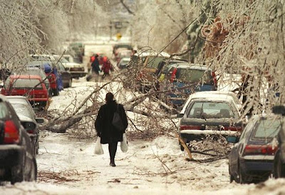
A Montreal street lies blocked by a maze of trees and wires during the Ice Storm of 1998. (Montreal Gazette).
Today is the 15th anniversary of the worst weather disaster in Montreal history, The Ice Storm of 1998. I will have more to say on that in another blog entry along with some pictures my family took from our Verdun home. In an ironic twist, after having spent the first 30 years of my life in Montreal, 20 of them observing and covering weather, I had just moved to Saskatchewan when the storm hit, and missed the entire event. The storm claimed dozens of lives and left the region without power for up to 1 month. Damage was in the billions of dollars including almost all of Hydro Quebec's power grid here in the south. The storm stretched from Kingston and Ottawa to Montreal and south into extreme northern Vermont and especially New York.

Monday, January 07, 2013

January thaw on the way

The cleanup continues in Montreal from over 60cm (2 feet) of snow that has fallen over the past two weeks. (CBC News)
It is another chilly morning in Montreal with current temperatures of -12C but as cold as -19C in Ottawa and points northwest of Montreal where clearing as already occurred. We hand another few centimetres of snow overnight adding to the 8cm that fell on Sunday and pushing us over 10cm for the event. This adds to our already deep snow pack. This may be a little problematic as we move forward later in the forecast period with much milder air and melting snow. For now it remains chilly today with near steady temperatures and clearing skies.

Clouds will be on the increase tonight as much milder air flows in from the southwest. Overnight lows will be reached by midnight with temperatures rising overnight. Highs on Tuesday will be much warmer then today, -6C, under partly cloudy skies. On Wednesday we are looking at a little snow as another weak system affects the St. Lawrence Valley and points north, much milder air will then flow into the region by the weekend. There is a significant difference in forecast highs by Saturday for Burlington, Vermont as compared with Montreal. While I do expect warm air to advance northward, deep snow cover in Montreal along with light northeast winds may keep the mercury down a little. If the warm air does make it this far north, we could be looking at highs above plus 5C (41F) by the weekend. Temperatures by Sunday could be as warm as 10C (50F) in portions of the region including New York, Vermont and possibly eastern Ontario. Enjoy it as it will last just a few days and indications are we will be back in the deep freeze by next week.

Friday, January 04, 2013

Weekend Update

We have a much milder morning underway in southern Quebec as compared with 24 hours ago. Here on L'Ile Perrot the mercury is at a balmy -12C, compared with the -25C we had yesterday morning around this time. This is the warmest it has been in the last 24 hours. We have a cold front off to our northwest with radar showing some pretty potent snow showers and squalls along it. A snow squall watch has been issued for western portions of Quebec down to the Ottawa Valley. If these hold together they may reach Montreal later this morning. Before that we can expect partly cloudy skies with temperatures continuing to rise to near -2C. Look for only 2-4cm of snow with the frontal passage along with some gusty winds, especially here in the St. Lawrence Valley. Southwest winds may gust as high as 70km/h here in Montreal. Skies will clear out by morning with a chilly Saturday expected under sunny skies and steady temperatures around -9C. On Sunday a similar system as that of today will bring another round of light snow with moderating temperatures. Into next week it looks like milder air will try to invade the region by weeks end with perhaps a more potent storm system. This system will bring milder air with the risk of snow and freezing rain and even rain for some regions.

Thursday, January 03, 2013

Baby it's cold outside!

A very cold January sunrise over frozen Lac St. Louis and the St. Lawrence Valley. I took this from the shoreline in Pointe Claire, Quebec. (ValleyWX)
With an arctic air mass over our region and deep snow pack, temperatures fell rapidly last evening after sunset. We managed to reach –18C (0F) by 5pm here in Montreal, and dipped all the way down to –23C (-10F) at the airport at 7am and –25C (-13F) at my home. Skies will remain sunny today with the temperatures slowly warming to –13C for a high by late in the day. They will remain steady overnight tonight or slowly increase as skies cloud over and light snow develops from west to east. The snow will continue most of the day Friday but be very light with perhaps 2 to 4cm falling in the next 36 hours. Temperatures, on gusty southwest winds between 30-50km/h in the St. Lawrence Valley, will warm to –5C. The weekend at this point looks sunny for Saturday but more light snow Sunday from another clipper type system. Temperatures will be near normal, -3C for highs and –14C for lows.

Other cold spots last night included –28C at Sherbrooke, -27C at Mirabel and Kemptville, Ontario. Across the Adirondacks temperatures dropped as cold as –30C (-26F).

Tuesday, January 01, 2013

Happy New Year

The celebrations are being held in 3C (38F) dry weather in NYC.
Happy New Year, thank you so much for following this blog and allowing me to share my passion for weather with all of you. I can't believe I am starting my 34th year writing about the weather, the last 7 as a blogger. This love for weather began in 1979 and continues to go strong today. It is only possible with all of you reading and dropping me comments and questions.

So to all of you, Happy New Year, and all the best in 2013.

Now back to weather. We start 2013 with an arctic cold front between Montreal and Ottawa at this hour. Look for increasing northwest winds and dropping temperatures overnight and into the daylight hours. Our high has been reached at midnight at 0C (32F) and temperatures will drop into the minus teens during the day today. There will be a brief period of  heavy snow and blowing snow along the front during the next few hours, this has prompted snow squall warnings for the Ottawa Valley at this point. They may be extended into Montreal during the next several hours. The gusty winds will make it feel colder as well as cause blowing snow. Skies will clear out on later towards morning.