Monday, June 30, 2025

Unsettled weather expected for Canada Day in Montreal

Happy Canada Day!
Saturday turned out to be a decent day across Eastern Ontario and Southern Quebec. Montreal managed to slip into the warm sector in the afternoon, with clearing skies and quickly warming temperatures into the upper 20s. We have a warm, muggy and at time thundery week ahead. (Valley Weather Photo)

The heavy rain expected over the weekend managed to fall mainly north of the Montreal region, leaving us in the warm sector of the system on Saturday afternoon. The result was a muggy high of 28C (83F) and a rather pleasant afternoon after the morning thundery rains. In terms of rainfall, between 15 and 20mm fell across the city, bringing the monthly total for June up to 40mm, which is still well-below the long-term average of 83.6mm.

We will end the month of June with plenty of sunshine and very warm temperatures, into the low 30s for many on Monday. The warm and humid air will remain through the evening and into the Canada Day holiday, with lows of only 21C (70F) forecast for Montreal. An advancing frontal boundary will set the stage for more widespread showers and thunderstorms from late this evening into Tuesday. Mother Natures fireworks!

Temperatures will remain warm along with muggy conditions Tuesday, with highs reaching 26C (79F). The balance of the week will be rather unsettled, with temperatures at or slightly above normal for early July, along with the risk of afternoon showers or thunderstorms. Humidity levels will remain moderate, so while conditions will feel muggy, it will not be oppressive like last week. In other words, typical July weather for Montreal. The warm and muggy air will persist into next weekend, with a renewed threat of thunderstorms arriving by Sunday.

Enjoy the Canada Day Holiday!

Thursday, June 26, 2025

Heavy rain possible to start the long weekend in Montreal

Heavy rain may produce areas of flash flooding across southern Quebec late Friday into Saturday. 50mm of rain or more is possible for some locations. Weather warnings may be required.

After the searing heat and humidity of this past week, conditions have turned much cooler on this Thursday in Montreal. On Tuesday, Montreal recorded its warmest June day since weather records began at Trudeau Airport, reaching 35.2C (95.4F). This surpassed the previous monthly high of 35.0C (95F) set back on June 9, 1980.

A series of weak disturbances have introduced cloud cover and a few showers Thursday, keeping temperatures much cooler. The forecast high for Montreal is 23C (73F).

Our attention will turn to a significant surge of moisture arriving ahead of the same warm and humid air mass that was present earlier this week. The heat dome will push a warm front north, approaching southern Quebec late in the day Friday.

Currently, forecasters expect a swath of very heavy rain and thunderstorms to set up just north of that front. Copious amounts of rain are forecast, with 25mm to as much as 100mm (1 to 4 inches) possible for some locations. Heavy rain and/or flood watches and warnings may be needed fro some regions as the event draws closer. Stay tuned if you have any weekend outdoor plans.

 The heaviest rain would fall from late Friday into Saturday for southern Quebec.

What is not clear at the moment is where that swath of rain will be. Models have it anywhere from central New York to right over the Montreal region. Where the most persistent heavy rain does occur, flooding will be a real possibility.

The clouds and rain will keep temperatures around the 20C (68F) mark into Sunday. Once the rain ends, a warm and humid air mass will remain into Canada Day, with highs approaching 30C (86F) once again. More unsettled weather in the form of showers and thunderstorms is possible next week.

Sunday, June 22, 2025

Heat Warning - Hot and humid weather forecast through Wednesday for Montreal

By the water in Montreal will likely be the best place to be this week, as temperatures soar well into the 30s, combined with high humidity. Widespread heat warnings are in effect across our entire region.

Heat Warning in effect for Montreal and Ottawa.

An area of showers and strong thunderstorms swept across portions of southern Ontario and Quebec overnight. This was the same system that produced deadly tornadoes over parts of the upper Midwest and northern plains on Friday. The worst of the weather passed to the west of Montreal and into upstate New York overnight. Montreal managed a few millimetres of much needed rainfall, along with plenty of thunder and lightning.

This now sets the stage for our first heatwave of the season, that will likely see high temperatures pushing into the middle 30s for many locations, and combined with elevated humidity levels, will push humidex (real feel) temperatures well over 40C (104F).

An expanding heat dome will produce dangerous heat form the central and southern plains, across the Great Lakes and into Quebec and Ontario. The heat will be dangerous. Highs in Montreal will be close to 30C (86F) Sunday and Wednesday, while Monday and Tuesday will likely be the hottest, with highs of 32C to 35C (90-95F). Overnight lows will provide very little relief, remaining in the middle 20s, perhaps above 27C (80F) in downtown Montreal.

Widespread heat warnings and advisories are posted for the eastern two thirds of North America. Take precautions and avoid strenuous outdoor activity during the most intense heat of the day. Stay hydrated, remain in air conditioned spaces if you can. Check on the elderly and the very young, keep your pets indoors, Remember to be extra careful with pets and children in automobiles, which can become unbearably hot in minutes.

Relief will arrive in the form of a cold front late Wednesday, with showers and thunderstorms and cooler weather by Thursday.

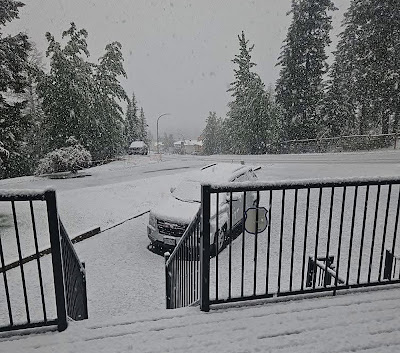
Meanwhile summer snow fell across the higher elevations of the Rockies in Western Canada on Saturday, including Elkford, BC shown above. A strong low pressure area produced heavy rain and mountain snow, along with strong winds across much of southern B.C and Alberta. My childhood friend Betty posted theses images on Facebook. (Elizabeth Jones)

Meanwhile while we swelter in the east, a strong storm produced heavy rain and mountain snow in British Columbia and Alberta. Gusty winds and cold temperatures produced several centimetres of snow across the the highest elevations of the Rockies in southeastern B.C. 

Thursday, June 19, 2025

Strong thunderstorms possible Thursday - heatwave next week

Strong thunderstorms producing heavy rainfall are possible Thursday afternoon across southern Quebec. Flash flooding will be possible with the strongest storms. (Valley Weather Photo)

Strong thunderstorms possible Thursday afternoon. 

Summer arrives at 10:42PM on Friday, and along with that will be the warmest air of the year to date. First off we have an active weather day across eastern Ontario and southern Quebec. The region has been blanketed by a sultry air mass, with a warm high of 30C (86F) on Wednesday and overnight lows remaining in the low 20s (70F). Along with elevated humidity levels, temperatures felt more like 35C (95F) Wednesday afternoon.

On Thursday, strong low pressure over northern Ontario, will move into central Quebec. Heavy rain will fall north of Montreal, with warnings already posted. A warm front has lifted north of of the city on Thursday morning, setting the stage for strong afternoon thunderstorms. Depending on how much clearing we receive, the storms could be severe locally.

The biggest threat for severe weather Thursday, including strong winds and hail, will be southeast of metro Montreal. (ECCC)

Most of the severe weather should occur south and east of Montreal. The main threat for the city west to the Ontario border, will be torrential rainfall, with the possibility of up to 50mm locally. That amount of rain over a short period of time could produce some flash flooding. Pay attention today to the latest forecast and any potential weather warnings.

After several flash flood events last summer in Montreal, we know which areas are prone to flooding. Try to avoid parking there today. Isolated showers will persist into Friday morning, before skies clear, with slightly cooler, less-humid air.

Over the weekend, the heat and humidity will begin to build back in, with more showers and thunderstorms late saturday and Sunday. Temperatures will start out in the mid 20s Friday, rising into the middle 30s by Tuesday. Dangerous heat, with humidex levels approaching 40C (104F) are possible in metro areas across southern Quebec, Monday and Tuesday.

Monday, June 16, 2025

Heat and humidity increase this week across southern Quebec

The weather was perfect all weekend for the Canadian Grand Prix at Circuit Gilles Villeneuve.
Light winds, low humidity and ideal temperatures greeted race fans in Montreal. More importantly after rain created significant problems for organizers,  fans and drivers in 2024, the weather remained dry for the entire 2025 three-day event. (F1.com photo)

High pressure anchored over southern Quebec managed to keep the clouds and rain to our south over New England and New York all weekend long.

As we move towards the summer solstice this coming Friday, the heat and humidity will start to build this week. The weather looks rather unsettled for the upcoming week, but not a washout by any means. June has been rather dry when compared to the rest of the spring in Montreal, so we could use some rainfall. To date, only 12mm of rain has fallen at Trudeau Airport in June.

The weekend was spectacular, with ideal conditions for the Canadian Grand Prix or any other outdoor activities. So as we start a new week, high pressure will give us one more ideal day, with sunshine and very warm temperatures. The high in Montreal will be near 28C (83F). 

Clouds and humidity will begin increasing tonight into Tuesday, along with higher dew points, making the airmass feel quite muggy. These conditions will prevail for most of the work week. We may see some isolated showers on Tuesday, with the chances for precipitation and even thunderstorms increasing into Thursday. Temperatures will remain warm, around 27C (80F) for highs and remaining warm overnight, in the upper teens to near 20C (68F). Slightly cooler air may arrive by next Friday or Saturday, but it will be short-lived as the heat will increase again by the Fête Saint-Jean here in Québec.

Wednesday, June 11, 2025

Montreal may have a rain-free weekend for the Canadian Grand Prix

A quick moving thunderstorm dumped torrential rain on Montreal on Tuesday afternoon. Thankfully the storm only lasted a few minutes, with 10mm falling at Trudeau Airport. (Valley Weather)

After a dismal spring that has had rain on just about every weekend, we may be looking at a break, just in time for the Formula F-1 Canadian Grand Prix in Montreal.

Weak high pressure is moving across southern Quebec on Wednesday, to be followed by a quick moving cold front this evening. That front will generate gusty southwest winds in the St. Lawrence Valley, possibly exceeding 50km/h through the overnight hours. There may be a spot shower or two, but no much precipitation is expected.

High pressure builds back in for Thursday and Friday, with brilliant sunshine and cooler, less-humid conditions. The high Wednesday will be close to 27C (81F0, dropping into the low 20s through the weekend. In terms of precipitation, dry weather is expected through late Friday. In the pre-dawn hours of Saturday, a warm front will lift north across New England. A few showers or isolated thunderstorms are likely along it. The question will be how far north will it move before heading back south.

The thinking at this time is that any showers will remain south of Montreal. Sunday at the moment looks ideal for the race, light winds, low humidity, sunshine, and a high of 24C (76F). The hope is that the venue will avoid the major problems they had last year, when over 30mm of rain fell over the course of the event, causing significant water accumulation on Ile Notre Dame.

Environment Canada is predicting a very hot and humid summer for Montreal and southern Quebec. Hot and dry weather expected across the Prairies, may exasperate the western wildfire situation, leading to more hazy and smokey days as well for our region. (ECCC)

HOT SUMMER ON TAP

Environment and Climate Change Canada has released the national forecast for summer 2025. It is simple, above normal temperatures for nearly all of us from June through August and likely persisting into the fall. Here in Montreal, we are expecting a hot and humid summer, with frequent thunderstorm activity. Northing new to see here, as this is quickly becoming the norm for southwestern Quebec of late.

One final note, Tuesday's quick moving thunderstorms dropped around 10mm on Montreal, brining the monthly total to 11.6mm. The same storms produced a small tornado in upstate New York, near Beekmantown, just north of Plattsburgh. The late afternoon EF-0 storm with winds of up to 120km/h, produced only minor damage. 

Monday, June 09, 2025

Air quality slowly improving in southern Quebec

Smoke from wildfires burning across northern Saskatchewan and Manitoba, produced some of the worst air quality on the planet in Montreal on both Friday and Saturday. Conditions began to improve on Sunday, and that trend should continue early in the week, with southwest winds and showers expected to"scrub" the air.

On Friday, southern Quebec and Ontario had some of the worst air quality among major cities on the planet. The hazy, smokey skies were created by high altitude smoke from the western Canadian wildfire, being driven closer to the surface on north winds. The result was a thick haze filtering out the sun and making it difficult on the eyes and respiratory systems. Air quality advisories were in effect for all our regions from Friday into Sunday morning before being lifted.

By no means is the air perfect Monday morning, with readings in Toronto and Montreal just under the unhealthy level on the air quality index at 94 and 93 respectively. That ranks the two cities 14th and 15th in the world Monday morning. Conditions should further improve late Monday as a warm front lifts north into the St. Lawrence Valley, accompanied by showers and southwest winds.

On Tuesday a cold front will generate showers and thunderstorms, with up to 10mm of rain possible. We need the moisture. To date, Montreal has only received 1.2mm of rain in June. The dry conditions have increased the risk of wildfires in the province, with SOPFEU reporting our region as extreme for fire risk. Outdoor burning should not be done under any circumstance in southwestern Quebec, until we receive some moisture. Conditions are expected to improve this week with the forecasted rainfall.

Temperatures this week will be seasonable, with daytime highs in the low to mid 20s and overnight lows in the middle teens. Unsettled weather, with showers and thunderstorms are likely from Monday afternoon into late Tuesday. By mid week, high pressure is expected to build into southern Quebec with plenty of sunshine to end the work week.

Friday, June 06, 2025

Western wildfire smoke drifts into southern Quebec

Filtered sunshine in Montreal due to western Canadian wildfire smoke has resulted in air quality advisories for southern Quebec. (Valley Weather)

A special air quality statement has been issued by Environment Canada regarding the western Canadian wildfire smoke that has drifted into eastern Ontario and southern Quebec on Friday morning. The smoke was present at higher altitudes earlier in the week, but has worked its way down to the surface currently, creating moderately poor air quality. 

Visibility is under 5km in Montreal at 8am, with widespread smoke and haze. There is definitely a smell of fire in the air Friday morning. The smoke and haze should remain through most of the day on light north and northeast winds, as the Montreal region lies to the north of a warm front over southern New England. The day will be hazy and warm, with a high of 25C (77F).

Environment Canada is advising residents to limit or reschedule outdoor activities until the air quality improves. 

Overnight, humidity levels will be on the rise as the warm front nears our region. Overnight lows will be very mild in the upper teens. On Saturday, we can expect another warm, and humid day, with haze and perhaps an isolated afternoon shower or thunderstorm, with a high of 27C (80F).

High pressure will nudge into the region on Sunday, with clearing skies and a warm high of 24C (76F). It should be one of the best weekend weather days we have had so far this year.

Over 60 Quebec firefighters and support staff left earlier this week to help the province of Manitoba battle widespread wildfires. The smoke form those fires arrived in southern Quebec Friday morning. (SOPFEU Photo)

The fires in Manitoba have forced the evacuations of thousands of residents form the central and northern part of that province, including the community of Flin Flon. There have been 111 fires in Manitoba so far in 2025, above the long-term average of 89. Thousands of hectares have burned, along with many structures. sadly there have been to fatalities.

Help as arrived from other Canadian provinces and the US, including 60 firefighters and personal from Quebec. A state of emergency is also in effect in Saskatchewan. The spring has been dry and warm in many locations, and while some rain and cooler temperatures are possible in the short-term, forecasters are expecting a hot dry summer for a large part of western Canada.

Monday, June 02, 2025

Summer weather finally returning to southern Quebec

That was one miserable weather weekend in Montreal, with a cold rain, gusty northwest winds and high temperatures in the low teens. Thankfully high pressure will build into southern Quebec for the upcoming week, with clearing skies and rapidly warming temperatures. By Wednesday, we may see our first 32C (90F) high temperature of the year in Montreal.

After an unseasonable cold and windy weekend, summer will quickly return this week to Montreal. Sunday was downright cold. The high in Montreal was only 13.1C (55F), well-below the normal high of 22C (72F), and just 0.8 degrees warmer than the all-time record low maximum for the date of 12.2C (54F) set back in 2003. Add in a gusty northwest wind, at times close to 60km/h and occasional showers and the day was just miserable, often feeling like the middle single digits.

Nobody could blame you for thinking that spring is getting off to a poor start. The data backs it up. In May, rain fell on 22 of 31 days. That amounted to 118.2mm, above the long-term average of 85.6mm for Montreal. Some form of precipitation has fallen on 12 of the last 14 weekends in Montreal. dating back to March 1st. Believe it or not, the May average temperature was actually very close to normal at 19C (66F). We can thank a few mild nights for shifting of the data.

SUMMER WARMTH

Now for the good news. High pressure is building into the region Monday morning and should prevail into early Thursday. Skies are already clearing out and we can expect sunshine through midweek. The result will be dry air finally, along with rapidly warming temperatures. Monday will see a high of 20C (68F), followed by a very summery 28C (83F) for Tuesday, and hot by Wednesday, with a near-record high of 32C (90F) possible. Overnight lows will start off cool, but warm as well to a muggy 21C (70F) by Wednesday. The only glitch in the weather will be the arrival of some high altitude smoke from the western Canadian wildfires. This will reduce the air quality a touch and provide hazy sunshine by Wednesday over much of southern Quebec and Ontario.

By Thursday, humidity levels will be on the rise ahead of a cold front arriving from the northwest. Showers and thunderstorms will be possible, continuing into Friday. Unfortunately, low pressure travelling along the front may prolong those showers into Saturday once again. The hope is skies should clear out late in the day, providing us with a sunny and seasonably warm Sunday.