 |
| Horrific flash flooding has claimed over 80 lives in the Texas Hill Country northwest of San Antonio. Several months worth of rain fell in just a few hours Friday morning catching both holiday weekend campers and residents off guard. (Photo: Carter Johnson) |
It was a tragic weather weekend in parts of Texas and the Carolinas as significant flash flooding claimed dozens of lives. The event shows just how quickly weather can turn violent, severe or even deadly. Despite the fact that weather warnings or watches often turn up empty, they cannot be ignored. Each situation is unique from the other.
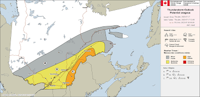
On Sunday in Montreal, severe thunderstorm watches and warnings were posted for cells that turned out to be less than impressive. That happens. Summer storms form and dissipate very quickly, often in less-than an hour. While Sunday's storms were not to bad on the island of Montreal, some parts of the province did have very heavy rain, hail, power outages and wind damage.
Here in Montreal, only a few millimetres of rain fell after a steamy day. The high was 33.2C (92F), just shy of the 2010 record high of 33.6C (93F). The day was unsettled to say the least, warm and humid, a trend that is becoming all too familiar this summer across large parts of North America.
On Monday, a cold front will sag south across the St. Lawrence Valley, with significantly cooler air, along with showers and thunderstorms. Some of the storms may produce heavy rainfall. The high today will be much cooler than Sunday, reaching only 22C (72F), with brisk northeast winds. Sunshine returns Tuesday, with the high warming back up to 26C (79F). The balance of the week will remain highly variable, with temperature and humidity levels creeping back up, and a few isolated showers or thunderstorms at times.
Texas Flood Disaster
The Texas Hill Country northwest of San Antonio and specifically the Guadalupe River Valley was the scene of horrific flash flooding in the pre-dawn hours Friday morning. Several months worth of rain, between 250 and 500mm (10-20 inches) fell in just a few hours during the overnight hours. While weather warnings and updates were numerous by the National Weather Service, most residents were sleeping and caught by surprise.
A rapidly moving wall of water swept down the Guadalupe River through Kerr County, turning the lazy river into a torrent in less than an hour. The river went from a few feet to major flood stage at over 29 feet. Flood stage is 22 feet. Residents and campers were swept away as homes and trailers were demolished. The death toll is terrible, currently at 82, including 28 children. Many of the victims were from Camp Mystic, an all girls camp on the edge of the Guadalupe. Rescuers continue to search for survivors but hope is diminishing. Resources have been pouring into the region from across Texas and the US.
The flooding occurred as an area of slow-moving thunderstorms tapped into deep Gulf of Mexico moisture producing torrential rain over the central portion of the state. Flooding in ongoing Monday morning in Texas.
Flooding is also occurring in North Carolina, as the remains of Tropical Storm Chantal move inland after making landfall along the South Carolina coast Sunday.


