Saturday, November 23, 2019

Active weather week ahead for southern Quebec

Another round of light snow is likely on Sunday in Montreal.
The mild weather of Friday has been replaced by a chilly Saturday morning in Montreal. Ile Perrot dropped to -8C (18F) overnight, after a daytime high of 7C (45F) on Friday. This was the warmest day in the last two weeks. The warmth along with gusty southwest winds and 2 to 5mm of rain, helped to melt much of the snow from last weeks storm. Warmer weather will return for the upcoming week before we dip below freezing for an extended period starting late this week.

In the short-term, high pressure will control the weather Saturday across southern Quebec, with a gusty southwest wind up to 40km/h and a daytime high of 2C (36F). The nice weather won't last long as our on and off again Sunday snowfall is back on. Computer models have been having a difficult time locking down the track of low pressure devolving over the lower Mississippi Valley. This system is now forecast to move across interior southern New England on Sunday. The path leaves Montreal on the extreme northwest edge of the precipitation shield. Expect clouds to increase overnight, with light snow or flurries possible on Sunday. Accumulations will be very light in Montreal, perhaps 2cm. Up to 10cm is possible over the Eastern Townships and Beauce, with 15 to 20cm over portions of northern New England. The snow will be wet, with highs near 0C (32F) forecast across the region.

Behind the low pressure, skies will clear out on Monday, with near normal temperatures expected. Another larger storm system is expected by mid-week in southern Quebec and Ontario, along with a mix of rain and snow possible. Behind that storm, very strong winds are likely by Thursday, along with dropping temperatures. 

Monday, November 18, 2019

More wintry precipitation for southern Quebec

Light freezing rain and snow will spread across extreme southern Quebec and New England late Monday and Tuesday. (AccuWeather.com)
After a sunny but very cold weekend, clouds are on the increase to start the week. Montreal had yet another record low this month, on Sunday morning at -13.2C (8.2F), crushing the previous low of -10.1C (14F) set in 1980. Monday should remain dry and cold, with daytime highs reaching -2C (29F) by late in the day. Clouds will begin to thicken this afternoon in response to a coastal storm moving north along the eastern seaboard and a trough moving east from the Great Lakes.

The combination of these two systems will bring a mix of light precipitation into Montreal very late this evening or after midnight. Montreal will remain on the extreme western edge of any major precipitation form the coastal system, but the trough from the Great Lakes will enhance moisture across the city tonight.

Not snow but sand blowing across the roads and ocean water forced the closure of portions of Highway 12 on the Outer Banks of North Carolina over the weekend. A strong coastal storm produced more significant damage and flooding to the same area that was heavily damaged by hurricane Dorian in September. (NCDOT Photo)
A mix of freezing rain and snow is likely in Montreal by midnight, changing to all snow overnight into Tuesday morning, and ending by afternoon. Accumulations will be fairly light in Montreal, but enough to make roads icy and perhaps force some delays at Trudeau Airport. Look for accumulations of 2 to 6cm for Montreal, with up to 10cm possible across the Townships and into the northern New England.

Townships under a freezing rain warning
Before the snow flies, the Eastern Townships can expect 5 to 10mm of freezing rain from late this evening into the overnight hours. Keep this in mind if your travels take you down Highway 10 towards Sherbrooke. Roads will be very icy in those regions. Precipitation amount with this storm system will taper off rapidly as you head north and west of metro Montreal, with very little if any snow expected for the Laurentians and Ottawa Valley.

The balance of the week will feature below normal temperatures, with another chance for snow or rain by late Thursday and Friday.

Thursday, November 14, 2019

From record snow to record cold across Southern Quebec

The City of Montreal is conducting the earliest snow removal operation ever this week after a record breaking 21cm of snow fell on the region. Another shot of light snow is forecast Friday, followed by arctic air for the weekend. (ValleyWeather Photo)
A strong cold front will produce snow squalls across Southern Quebec and eastern Ontario Friday afternoon between 4 and 7pm.

A weak warm front is giving southern Quebec some very light snow late Thursday afternoon. Very little in the way of accumulation can be expected. The good news is that we can expect some warmer temperatures through Friday morning as we head out of the deep freeze for a few hours.

It has been a cold, snowy week, with a record setting 21cm of snow Monday and Tuesday, followed by two days of extremely cold weather for early November. On Tuesday we broke both records for coldest nighttime and daytime temperatures, the low was -10.9C (12F) (-9.4, 1971) with a high of only -4.6C (23.7F). We did the same Wednesday, with a low of -13.5C (8F) (-10.5C, 1986) and a brutally cold high of -7.1C (19F). Windchill reading were in the minus 20s, some of the coldest ever recorded so early in the season in Montreal.

The storm brought the monthly snow total so far to 29.6cm, well above the normal of 20cm, which is for the entire month.

More cold air is on the way. After the brief influx of mild air, a potent arctic boundary will slide across southern Quebec Friday afternoon. The front will be accompanied by scattered snow flurries and squalls. Visibilities may be reduced in sudden bursts of heavy snow during the afternoon hours. The front will bring even colder air to the region than that of earlier in the week. The high on Friday will be 2C (36F) reached during the midday hours. Temperatures will drop rapidly behind the front, down to -15C (5F) by Saturday morning in Montreal.

The weekend will be blustery and cold, but sunny with highs around -5C (23F). We may add two more record lows to the books, Saturday's record is -15C set in 1967 and Sunday's is -10.1C set in 1980. Milder air returns early next week, but temperatures will still remain below the normal high of 5C (41F) for mid November. There will be a chance of rain or snow showers by Tuesday.

Monday, November 11, 2019

Snowfall warning for Montreal

A potent fall storm will spread heavy snow across southern Ontario into southern Quebec to start the week. Anywhere from 15 to 30cm is forecast along the St. Lawrence Valley and points south. A little less, 10-15cm is expected in Ottawa. Record cold will surge into the region behind the storm. (AccuWeather.com)
Snowfall Warning in effect for Montreal

Widespread winter storm warnings are now in effect for a swath of eastern Ontario, southern Quebec and parts of the Northeast US and New England. An arctic boundary has slipped south of Montreal early Monday morning, with much colder air pouring into the region. Temperatures have fallen from a Sunday high of 6C (43F), down to -5C (23F) at 5am Monday. The cold air will remain with us for the balance of the week, with record low temperatures likely by Wednesday morning.

Low pressure developing over the Ohio Valley will lift northeast along the aforementioned arctic front through Tuesday. Moisture will overspread the region late Monday, with snow developing by the afternoon hours. The snow will become heavy overnight into the Tuesday morning commute in Montreal. This is a potent snowstorm for anytime of the season, but especially in early November as the first storm of the season. At this time forecasters are anticipating 15 to 25cm along the St. Lawrence Valley including Montreal, with up to 30cm across the Eastern Townships, northern New York and New England. The snow will spread into eastern Quebec Tuesday, accompanied by 50km/h winds, producing blowing snow.

If you have any travel plans from late today into Tuesday, consider postponing them or allow yourself plenty of extra time. Do yourself and everyone else a favour on the roads, if you have no winter tires on yet, use public transit. Be safe.

Friday, November 08, 2019

First snowstorm of the season possible for Montreal

Strong winds and wet snow are bringing a quick end to the fall foliage season across southern Quebec.
Our first taste of winter weather this season is upon us across southern Quebec, as a strong cold front produced 2 to 10cm of wet snow on Thursday. Most of the snow melted on contact acorss the Island of Montreal, but many off-island suburbs, including Ile Perrot, measured a coating to 2cm of slushy wet snow.

Early Friday morning, a few snow showers moved across Ile Perrot and the Vaudreuil/Dorion region, putting down a quick centimetre of snow. The sudden snow made for a very icy commute, at least until reaching the West Island, where no snow had fallen. Consider this the appetizer to a more potent storm early next week.

Montreal may be looking at our first snowstorm of the season, depending on the exact track of low pressure moving across southern New England early next week. (AccuWeather.com)
First snowstorm of the season?
Friday will be breezy and very cold for early November, with the temperature reaching only -1C (30F), the normal high should be 8C (48F). There is a chance for a few flurries today, as well as gusty northwest winds up to 40km/h, making it feel even colder. On Saturday, high pressure will move in giving Montreal a decent, milder day, with a high near 2C (36F). Sunday will be warmer as a frontal boundary approaches form the west. Expect a few showers around as daytime highs reach 6C (43F). The warmth will be short-lived.

A strong polar front crossing the region late Sunday, will usher in the coldest airmass of the season so far, with temperatures dropping to -10C (14F) by Monday morning. That front will stall across southern New England, setting the stage for Tuesday's potential snowstorm. Low pressure will develop over the Ohio Valley, and move along the front towards southern New England. The storm is forecast to deepen rapidly. Snow will spread into eastern Ontario and southern Quebec late Monday night and persist through Tuesday. Depending on the exact track of the storm and how far south the front settles, we may be looking at a significant snowfall in Montreal. It remains too early for specific amounts, but it should be enough to plow. My current thinking is 10 to 15cm, but this is subject to change.

I will post further updates over the upcoming weekend.

Wednesday, October 30, 2019

Strong fall storm forecast to dampen Halloween spirits

In keeping with the trend this October, Southern Quebec will have a wet Halloween. Montreal has measured nearly 200mm of rain this month, more than double the normal of 90mm.
A strong low pressure system is forecast to develop over the Ohio Valley on Thursday and deepen rapidly as it  lifts northward across the Great Lakes and into central Ontario. The storm is expected to produce a wide variety of stormy weather from heavy snow north and west of the track, to severe thunderstorms and powerful winds south and east of the low.

Heavy rain is forecast to develop on Thursday across the St. Lawrence Valley, making for a gloomy wet Halloween. Up to 50mm may fall in Montreal, with even more possible south and west of the city.
Showers are expected to develop in Montreal on Thursday afternoon, becoming a steady rain by the evening hours. Heavy rain is forecast overnight into Friday morning, with as much as 50mm (2 inches) expected in Montreal. October has been very wet for the city, with close to 200mm (8 inches) of rain to date. The average rainfall for Montreal is closer to 90mm. The heavy rain will produce rapid rises on rivers and streams in the region. Some minor flooding is possible. As well, tons of leaves will hit the ground, clogging sewers. In addition to the heavy rain, a swath of wet snow is forecast across central Ontario into central Quebec, with as much as 15cm possible in places like Val d'or .

The system will be a very deep fall storm, with strong winds anticipated on Friday. As the storm lifts into central Quebec, southwest winds will approach 100km/h (60 mph) in the St. Lawrence Valley including metro Montreal. Winds this strong are capable of tree damage and power outages. Wind gusts may approach hurricane strength of 120km/h (75mph) across portions of the eastern Great Lakes and northern New York. Numerous watches and advisories have already been issued, and I expect weather warnings will be needed for Montreal and southern Quebec later today as the storm develops.

Temperatures will be very mild on the east side of the low pressure area, reaching into the middle teens in Montreal Wednesday and on Halloween. As the storm moves off to our north temperatures will drop rapidly on Friday, down to 5C (41F). A few flurries are even possible on Friday and Saturday across southern Quebec and eastern Ontario.

Saturday, October 26, 2019

Remains of tropical storm Olga to soak southern Quebec

The remains of poorly organized tropical storm Olga will move northeast along a frontal boundary, producing a rainy, windy Sunday for southern Ontario and Quebec. (AccuWeather.com)
Tropical storm Olga quickly developed on Friday over the northern Gulf of Mexico and almost immediately became absorbed by a frontal boundary. The system remained rather weak and disorganized, with gusty winds of 90km/h (50mph) and heavy rainfall being the main threats. Isolated coastal flooding was also reported over east Texas and southern Louisiana. As of late Friday evening, what was left of the storm was located over central Louisiana.

Meanwhile high pressure was building into southern Quebec, with a cool, frosty start to the weekend in Montreal. Saturday will remain dry, with sunshine and cool weather forecast. Highs will reach 12C (54F). Clouds will be on the increase early Saturday evening, with temperatures dropping rapidly after sunset and then leveling off around 5C (41F). The remains of Olga will advance northeast on Sunday across the Ohio Valley and into the Great Lakes. Expect rain to develop before sunrise over southwestern Quebec, becoming moderate at times, with 20 to 25mm likely. This will add to our already extremely soggy October in Montreal, with 160mm down so far. Normal rainfall is only 89mm for the entire month. Sunday will be cool, with highs struggling to reach 10C (50F). Condtions will be breezy as well, with winds gusting to 50km/h.

Skies will clear on Monday, with very mild highs of 16C (60F). The good weather will be short-lived, as a deepening storm system and cold front will bring rain and even some snow to locations in Ontario and Quebec by the middle portion of next week. The Halloween weather in Montreal looks gloomy and wet for now. Much colder weather will follow this storm system as we head into early November.

Friday, October 11, 2019

Southern Quebec remains between major storms

Heavy snow is making for very difficult travel this morning across southern Manitoba and eastern North Dakota. (NDSP Photo)
The best weather across the country is right here in southern Quebec and eastern Ontario as we head into the Thanksgiving holiday weekend. High pressure is dominating the skies, with bright sunshine and above normal temperatures. These conditions will prevail over the weekend, with just a slight chance of a few showers late Saturday night as a cold front crosses the region. Sunshine returns Sunday and Monday, with temperatures just a touch cooler. The high will be near 17C (63F) Friday and Saturday, 13C (55F) Sunday and Monday.

Major Storms
While we have nearly perfect fall weather here in Montreal, major storms are impacting the east coast and across the Prairies and northern plains. A large early winter storm is hammering the Rockies and plains with heavy snow and winds in excess of 80km/h. Up to 3 feet of snow is forecast in sections of North Dakota by Saturday night. Denver, which had highs over 27C (80F) just two days earlier, was well below freezing with heavy snow on Thursday. The snow and wind will spread into southern Manitoba and northwest Ontario today, where winter storm warnings are in effect. Travel will become nearly impossible today across the Dakotas and southern Manitoba, with heavy wet snow and winds up to 100km/h. Power outages and tree damage are likely. The snow will taper off Saturday as the storm weakens and moves into Ontario.

The Atlantic Ocean spills onto North Carolina State Route 12 near Rodanthe, North Carolina on Thursday. A strong Nor'easter located well offshore continues to produce coastal flooding. (OBX Today)
Along the eastern seaboard, a strong Nor'Easter has been blasting coastal regions from North Carolina to New England with heavy rain, strong winds and flooding. Sections of Highway 12 were washed out late Thursday along the Outer Banks of North Carolina. The storm will drift northeast over the weekend impacting coastal Nova Scotia with heavy rain, strong winds and high seas.

Wednesday, October 02, 2019

Strong October thunderstorms produce flooding in Montreal

Strong thunderstorms produced widespread flash flooding during the evening commute in Montreal. (ValleyWeather Photo)
Frost Advisory in effect for southern Quebec.

A slow moving warm front became the focus for strong thunderstorms on Tuesday across southern Quebec and especially here in the Montreal region. Torrential rain fell on the city between 2 and 6pm producing widespread flash flooding across several regions of the city. Wicked lightning and thunder accompanied the storms, more common for Montreal in July than October.

A record breaking 48.4mm of rain fell at Trudeau Airport on Tuesday, surpassing the previous daily high of 34.3mm set in 1945. The rain overwhelmed sewers flooding basements and closing several roads including Highway 20 at Boulevard Angrignon. The flooding and heavy rain made for a long evening commute for many. The storms were part of the same weather system that produced record high temperatures across southern Ontario. Over a dozen record highs were observed on Tuesday, including 31.8C (89F) in Toronto, surpassing the previous record of 29.5C (85F) set in 2002. It was also the warmest high ever recorded in that city in October. While southern Ontario was basking in summer warmth, flurries and temperatures near 0C (32C) were occurring across northwestern portions of the province.

Montreal remained in the cool, moist air to the north of the front for most of the day, finally warming to 17C (63F) by the early evening.

The new section of Highway 20 near Boulevard Angrignon, was turned into a lake during the severe thunderstorms Tuesday afternoon. Transport Quebec was forced to close the road in both directions , snarling traffic for hours. (CTV)
First frost
Behind this weather system, much colder air will pour into southern Quebec, with a good chance for the first frost of the season early Wednesday morning. Frost advisories are in effect for the entire region, including metro Montreal, with overnight lows forecast between 0C and 2C (32 to 36F) in the city and as cold as -3C (27F) north of Montreal. Frost is also expected in eastern Ontario away from the St. Lawrence River.

Monday, September 30, 2019

Historic snowstorm hammers southern Alberta and Saskatchewan

A rare September snowstorm dumped over 90cm of thick wet snow on southwest Alberta over the weekend. (Photo via Twitter @rbgibbfarms and The Weather Network)
A three day historic September snowstorm is winding down early Monday morning across southern Alberta and southwest Saskatchewan. The storm dumped huge amounts of wet snow across the region, with close to 100cm (40 inches) in Waterton Park, Alberta. Lethbridge recorded 45 to 55cm, with 31cm in Calgary. On Sunday alone, 24.6cm of snow fell in Calgary, breaking the single day September record of 22.9cm established on September 19, 1895. The storm responsible for the snow was packed with Pacific moisture, moving inland across Idaho and into Montana.

Across the border in northwest Montana, even more snow fell, with an unbelievable 122cm (48 inches) at Browning, Montana. Brownings average annual snowfall is 151cm (59.5"), and we are not even out of September! The storm produced the usual mid-winter problems, with major travel delays and power outages reported. Numerous trees fell under the wight of the heavy snow.

Northern Montana measured even more snow than Alberta. (via Twitter @aaronjayjack)
Snow also fell across southwest Saskatchewan on Sunday, with accumulations in the 15 to 25cm range forecast from Moose Jaw and Swift Current south towards the US border. It is common for snow to fall on the edges of the seasons in Saskatchewan, but the amount, intensity and duration experienced with this storm are rare. When I lived in southern Saskatchewan between 1997 and 2000, the two biggest snowstorms I encountered were in October and May.

Warm weather in the east
While the snow was swirling across the west, warm and humid air surged into eastern North America. Dozens of records highs were set across the eastern US, with highs pushing into the middle 30s (90s) in many locations. Temperatures were quite warm in southern Ontario over the weekend, but slightly cooler here in southern Quebec. The weather in Montreal for the start of October will be quite unsettled. Showers and thunderstorms are likely Tuesday, along with mild high temperatures in the low 20s. By the end of the week, much cooler arrives on gusty northwest winds, with highs by Friday and Saturday only in the low teens.

Friday, September 27, 2019

Huge snowstorm for parts of western Canada - mild weather continues in the east

The first snowstorm of 2019 is forecast to dump 25 to 60cm of wet snow on southern Alberta, interior portions of southeastern B.C. and adjacent Montana over the weekend. (NWS Photo)
I apologize for the lack of weather talk in recent weeks. I hate it when real life gets in the way of my chosen passion. A few extra responsibilities here at The Suburban have kept me from writing as much as I would like to.

Thankfully the weather has been fairly quiet over the last few weeks in Montreal. September has been beautiful across southern Quebec, an extension of the summer really. As with the past few years, September has become just another summer month, with average temperatures running above normal, into the lower to mid 20s. We have yet to see frost in metro Montreal, which is normal. We should see some colder nights over the next couple of weeks that will help the leaves along with their colour and also produce some frosty mornings. Daytime temperatures will remain at or slightly above normal through the weekend across southern Quebec.

Precipitation has been above normal for September, with 93.4 mm to date. Showers are forecast on Saturday and once again late Monday, which should allow Montreal to exceed 100mm (4 inches) for the month.

Historic Snowstorm
The big weather news this weekend will be the historically early snowstorm expected to impact portions of interior British Columbia, southern Alberta and northwest Montana. A strong Pacific storm will move into the Rockies over the weekend, combining with an unseasonably cold airmass. The result will be heavy wet snow along the spine of the Rockies and into the foothills west of Calgary. Snow is forecast to start late Friday and persist in some locations into early Monday. Some computer models are estimating as much as 50cm of snow across southwest Alberta. Winter storm watches have been issued. The heavy wet snow will fall on trees that are still in full bloom, with the possibility of major damage occurring. Power outages and very poor travel conditions are expected as well, especially west of Calgary along the Trans Canada Highway into B.C. Strong winds are also forecast with the storm, in excess of 100km/h. The same conditions are forecast in northwest Montana where weather warnings are already in place.

The weather is eerily similar to that of fall 2018, when a massive snowstorm hit Calgary southern Alberta on October 2.

Sunday, September 15, 2019

Perfect weather to end summer in Montreal

The full harvest moon rising over the St. Lawrence River in Montreal. Perfect late summer weather is expected this week to end the season. (Valley Weather Photo)
After a rather cool, wet start to September, southern Quebec is in for a stretch of spectacular late summer weather. Temperatures so far this month have been relatively close to normal, averaging either side of 21C (70F) for highs, with lows around 10C (50F). The precipitation to date has been well above normal. On Saturday, a frontal system produced a round of showers through mid-morning, dropping another 7 to 10mm of rain on the Island of Montreal. That brought our monthly total up to 79.4mm, which is very close to the normal  for the entire month of 83.1mm.

The good news is dry weather is on the horizon as strong high pressure is forecast to crest over southern Quebec and eastern Ontario this week. Expect mostly sunny skies, with cool nights and warm afternoons. The temperatures will rise through the week, reaching close to 27C (80F) by next Saturday. No rain is in the forecast this week, with just some periodic cloudy periods expected at times today and Monday.

Fall arrives on Monday, September 23 at 3:50am, so get out and enjoy the upcoming week.

Tropical Storm Humberto
The follow up to catastrophic hurricane Dorian has been more of a nuisance than anything so far. Tropical storm Humberto was located 220km north, northwest of Great Abaco Island on Sunday morning, with 100km/h winds. Humberto added to the misery on Great Abaco Island Saturday, producing breezy conditions and rain in the storm stricken region. Humberto is expected to strengthen to hurricane status within the next 24 hours, but is thankfully moving away from the Bahamas. The storm may impact Bermuda later in the upcoming week.

Conditions continue to be dire in The Bahamas, with a mounting death toll and hundreds still missing. If you can help, please consider donating to the Canadian Red Cross Hurricane Dorian Appeal at this link.

Sunday, September 08, 2019

Dorian slams Atlantic Canada - will finally dissipate in North Atlantic this week

A vehicle lies crushed by a roof torn from a Halifax building by Hurricane Dorian's 145km/h winds. (CBC)
Hurricane Dorian roared inland near Sambro Creek, Nova Scotia, just south of Halifax, around 6:15 pm Saturday evening. The category 2 storm, the first of that strength in Canada since Juan in 2003, swept across the province tearing down trees and power lines. A storm surge swept into Halifax Harbour and many neighbouring communities producing damaging flooding. The combination of wind and debris knocked out power to over 500,000 homes at the height of the storm. Numerous trees were torn from their roots by the powerful storm, blocking roads and crushing roofs and vehicles. A large construction crane was twisted and knocked down in Halifax. Schools across Nova Scotia and Prince Edward Island will be closed on Monday, allowing crews to continue the damage assessment and cleanup.

A construction crane was toppled in downtown Halifax by Dorian's fierce winds. (CBC)
Peak winds observed with Dorian across the Maritimes were 145km/h at Beaver Island, Nova Scotia, 107km/h at Halifax, and 122km/h at North Cape, Prince Edward Island. Heavy rain occurred as well, with 121mm in Moncton, 138mm in Oxford and 90mm in Halifax.

Dorian also produced 120km/h winds across Iles-de-la-Madeleine, Quebec, where widespread damage was reported. A state of emergency is in effect, with power out to over 7000 residents. Hydro Quebec has 30 employees on the islands to complete the restoration.

Dorian is now impacting Newfoundland and coastal Labrador, with 100km/h winds. The storm was located 100km west, southwest of St. Anthony, Newfoundland at 6pm, moving northeast at 37km/h. After the storms two week run of damage and death, Dorian is finally forecast to weaken as it moves into the North Atlantic early this week.

Saturday, September 07, 2019

Hurricane Dorian to sweep across Nova Scotia today

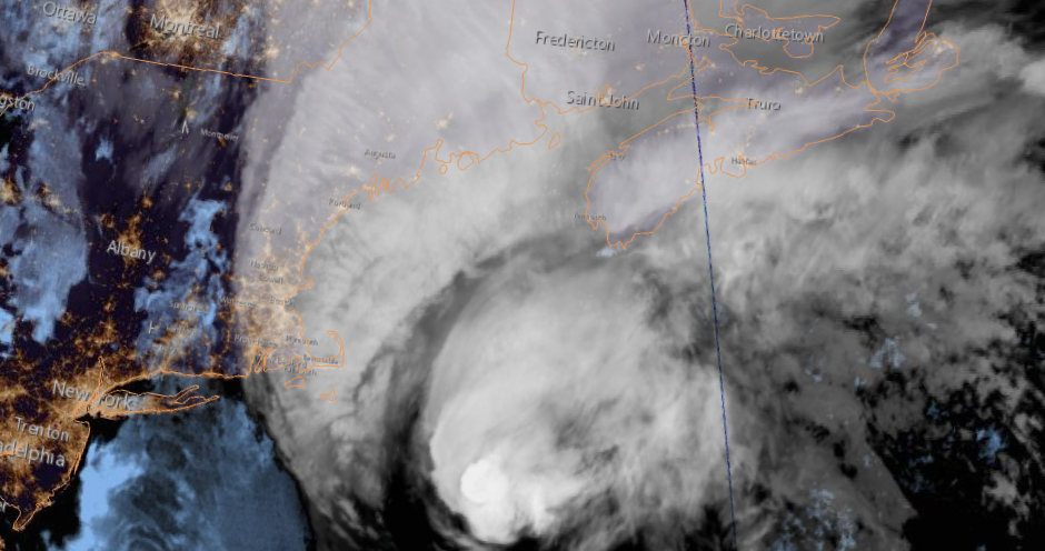
NOAA image of Hurricane Dorian located east of Cape Cod and south of Nova Scotia early Saturday morning. (NOAA)
Early Saturday morning, hurricane Dorian was located 660km southwest of Halifax, racing towards the northeast at 41km/h. Dorian has still maintained category 1 status, with winds gusting to 140km/h. Hurricane warnings are in effect for Nova Scotia and P.E.I., with tropical storm warnings posted for portions of New Brunswick, Newfoundland and eastern Quebec. Montreal and southern Quebec will have no weather impacts from Dorian.

Ocracoke Island, North Carolina was inundated by a 7 foot storm surge produced by Dorian on Friday. The tiny barrier island sustained major damage as did neigbouring Hatteras Island. (Hyde County Sheriff Office)
Waves and winds are increasing along the south coast of Nova Scotia Saturday morning, with hurricane conditions expected in Halifax by late this afternoon or this evening. At this time, most locations in the warning area should see winds of  90 to 120km/h, but gusts up to 150km/h are possible along the coast. Heavy rain will fall along and west of the track, with up to 150mm possible. Flooding will be a major concern in western Nova Scotia ans southern New Brunswick. A storm surge of  several metres is expected, especially along the south coast of Nova Scotia and in the Gulf of St. Lawrence. Waves of 5 to 10 metres are also likely in the warning area. Flooding, tree damage and power outages as well as some structural damage are major concerns today across the Maritimes. Dorian will move into Prince Edward Island tonight and across the Gulf of St. Lawrence on Sunday morning.

Dorian will  then begin to transition into a powerful post-tropical storm Sunday as the system moves rapidly across Newfoundland and into the North Atlantic.

Wednesday, September 04, 2019

Dorian devastates The Bahamas heads for the Carolina coast

Hurricane Dorian caused the complete and total destruction of most dwellings on Great Abaco and Grand Bahama Islands in The Bahamas. The storm spun over the islands for over 36 hours. (US Coast Guard Photo)
Paradise lost...
Complete, unprecedented damage is what is left behind on Great Abaco and Grand Bahama Islands after 48 hours of fierce winds and pounding seas from hurricane Dorian. The once category 5 hurricane battered the northwest Bahamas with a 20 foot storm surge and 185 mph winds through the weekend and into Monday. The damage is just incredible, with most structures simply gone. Cars and boast are submerged, power lines and trees ripped form the ground. The death toll stands at 20, but is likely to climb as rescue workers arrive in the hardest hit areas.

The US Coast Guard has conducted numerous rescues, in some cases pulling people from rooftops after several days. Both islands were completed inundated with the storm surge. Relief is pouring in from several countries including Canada, which has pledged $500,000, with additional aid to follow.

The eye of hurricane Dorian was located off the Georgia coast late Wednesday afternoon. (NOAA)
Dorian skirted the Florida coast on Wednesday, bringing storm surge flooding and heavy rain, but damage was minor. Hurricane Dorian at 8pm Wednesday evening was located 410km south southwest of Wilmington, North Carolina, with 175km/h winds. Dorian is moving northwest at 15km/h, with a gradual turn towards the northeast forecast on Thursday. The hurricane is expected to remain just offshore of the southeast US coast, perhaps making landfall along the Outer Banks of North Carolina. A hurricane warning extends northward to the Virginia border. Heavy rain in excess of 200mm is forecast along the track of the storm. Storm surge flooding is also expected along coastal areas.

Dorian to hit Atlantic Canada
By Saturday, hurricane Dorian is expected to sweep into the Maritimes with significant impacts. The Canadian Hurricane Centre is predicting winds of up to 140km/h as well as heavy rain, in excess of 50mm for portions of Nova Scotia and Newfoundland. Storm surge flooding is also expected in coastal communities. Far eastern Quebec will also receive rain and gusty winds from Dorian. Montreal will be too far west for any weather from the storm, with the exception of perhaps a gusty northeast wind filtering down the St. Lawrence Valley. The current forecast calls for Dorian to move across central Nova Scotia by late Saturday afternoon, approaching Newfoundland by early Sunday.

Sunday, September 01, 2019

Dorian strongest Atlantic hurricane in modern times to hit The Bahamas

Images shared on social media show widespread damage and flooding on Great Abaco Island in the northern Bahamas.
Hurricane Dorian became a monster storm Sunday, tearing apart Great Abaco Island for most of the day. The storm exploded early this morning, reaching category 5 status and beyond. Dorian became the strongest hurricane in modern times to strike The Bahamas, and one of the most intense on record in the Atlantic basin. Peak winds reached 185mph, and have since lowered only slightly to 180mph (285 km/h) as of the 11pm observation Sunday night.

Dorian became one of the strongest hurricanes on record in the Atlantic basin today, as winds reached 185mph. (Tropical Tidbits)
Dorian is crawling achingly slowly at 9km/h, prolonging the battering the northern Bahamas is sustaining. The slow movement has resulted in massive flooding, power outages and the complete failure of most structures. Images and video shared on social media show tremendous damage on Graeat Abaco Island. The storm is now impacting Grand Bahama Island and Freeport. Catastrophic damage is expected in those locations as the winds scour the region overnight and into Monday.

Winds and waves will increase on Labour Day along the Florida coast as Dorian inches dangerously close to a US landfall. Forecasters expect that Dorian will remain just offshore, however just a slight wobble would bring the eye inland along the central Florida coast. As of late Sunday, hurricane warnings were now in effect along the Florida coast and evacuations were ordered in several counties.

Briefly looking ahead, Dorian is expected to sweep the southeast coast as far north as the Outer Banks. While weakening is expected, Dorian will remain a very dangerous hurricane for most of the upcoming week.

Category 5 Dorian battering northern Bahamas

A textbook image of category 5 hurricane Dorian early Sunday morning. (Tropical Tidbits)
Early Sunday morning, hurricane Dorian was upgraded to a powerful category 5 storm, with winds of  260km/h (160 mph). The storm is battering the northwest Bahamas, and expected to do so through Monday. The slow moving hurricane is drifting west at 15km/h. Dorian was located 55km east of Great Abaco Island. Catastrophic damage from wind, rain and storm surge is possible with a category 5 storm.

Hurricane warnings remain in effect for the northwest Bahamas, while a tropical storm warning is in effect for the Florida coast from  Deerfield to Sebastian Inlet. A tropical storm watch is in effect north to Golden Beach. Winds and waves will begin increasing along the Florida coast late tonight and on Labour Day.

Some computer models now have Dorian remaining off the Florida coast and turning sharply north then northeast early this week. The hurricane now poses a serious threat to the North and South Carolina coast, including the extremely fragile Outer Banks. A state of emergency remains in effect for Florida, Georgia and the Carolinas.

Saturday, August 31, 2019

Powerful hurricane Dorian threatens Bahamas and Florida

A stunning infrared image of hurricane Dorian early Saturday morning. Dorian was located 755 km east of the Florida coast at 5am. (Tropical Tidbits)
Early Saturday morning, powerful category 4 hurricane Dorian was located 755 km east of West Palm Beach, Florida. The storm was in a very favorable environment to maintain the current strength or perhaps even grow slightly. Winds were measured at 220km/h (140 mph) with higher gusts. Dorian was moving west northwest at 20km/h.

Developments over the last 24 hours have included a hurricane warning for the northwest Bahamas, as well as mandatory evacuations of the barrier islands of Brevard County, Florida. Some coastal communities in Florida have also issued voluntary evacuations for those who wish to leave early. There has been a run on water and gas in south Florida, and those items are in short supply. Portions of the Florida coast may see a hurricane watch issued some time Saturday.

As far as the future of Dorian goes, the path is not so clear. The storm is forecast to slow to a crawl as it approaches the Bahamas, thus prolonging the devastating impacts for that region. Dorian may take the entire weekend to clear the Bahamas before approaching the Florida coast late Labour Day Monday or Tuesday. A strong ridge of high pressure that has been forcing Dorian west, may begin to erode allowing the storm to turn towards the north. Some computer models now have the hurricane remaining off the Florida coast and moving north into South Carolina before impacting the Outer Banks of North Carolina. NOAA Hurricane Hunters are scheduled to fly into Dorian several times Saturday, relaying vital information to help with the forecast track.

Dorian remains a very dangerous storm, posing several widespread threats from The Bahamas to Florida and north towards Virginia.

Friday, August 30, 2019

Strengthening hurricane Dorian takes aim at south Florida

A visible satellite image of a strengthening hurricane Dorian, located east of the Bahamas on Friday morning. (Tropical Tidbits)
Hurricane Dorian now a major category 3 storm.

Hurricane Dorian is forecast to become a powerful category 4 storm over the Labour Day weekend while crossing the northwest Bahamas on the way to south Florida. Dorian was located 1000 km east of West Palm Beach, Florida at 2pm Friday, with 185km/h (115 mph) winds. The hurricane was moving northwest at 17km/h. Dorian will be in an ideal environment for strengthening over the next 48 hours, with forecasters expecting a major hurricane at landfall. Water temperatures are very warm in this part of the Atlantic Ocean and wind shear aloft, which can tear apart storms, is expected to diminish.

So far the damage from Dorian has been minor, with mostly flooding and power outages reported in the Virgin Islands. That may change for Florida and the Bahamas as the storm begins to rapidly intensify. (bvitraveller.com)
The big question is where is Dorian going? The forecast has become more complicated over the past 12 hours, with models expecting the storm to slow to a crawl as it approaches the Florida coast. A slow storm at landfall is bad news. This will prolong the heavy rain, strong winds and pounding surf. A long duration onshore flow will lead to significant coastal flooding. Dorian is expected to slowly move into Florida by Labour Day, before turning northward and moving into Georgia and the Carolinas. Dorian will impact the southeast US from late this weekend well into next week. A state of emergency has been declared in Florida and Georgia, with preparations well underway.

I will continue to monitor the progress of Dorian, providing updates via my Valley Weather Blog as well as at The Suburban Weather Page.  For the most complete and accurate tracking information, you can visit the National Hurricane Center website.

On a personal note, September 2019 marks 40 consecutive years that I have been tracking Atlantic Hurricanes, starting with Hurricane David in 1979.

Wednesday, August 28, 2019

Tropical Atlantic heating up

A NOAA GEOCOLOR image of Tropical Storm Dorian in the US Virgin Islands early Wednesday morning. The storm will likely reach hurricane status today before approaching Puerto Rico later today. The system may impact Florida or the US southeast by the weekend.
As a kid growing up, Labour Day meant a few things to me. There was the end of summer and back to school, a moment I despised, I am after all a huge fan of summer, always have been, the Jerry Lewis Labour Day Telethon, which ran for decades, and of course tracking hurricanes. It seems the Labour Day long weekend and hurricanes go hand in hand. I have been tracking the storms since 1979, and rarely a year goes by without a named storm to end the summer. We are in the peak of Atlantic hurricane season, so it is no surprise that we are dealing with two storms as we end August.

Tropical storm Dorian, the more dangerous of the two systems, is located 140km southeast of St Croix in the US Virgin Islands early Wednesday morning. The storm is moving northwest at 20km/h, heading towards Puerto Rico. Winds are gusting to 60mph (95km/h), with some strengthening forecast today. Dorian is expected to become a hurricane as the system moves near Puerto Rico. By the upcoming weekend, the storm will be approaching the northwest Bahamas and the central Florida coast, likely as a hurricane. All interests form the Carolinas into Florida and the Gulf of Mexico should continue to monitor the progress of this storm.

Meanwhile further north, Tropical depression Erin has developed about 430 km east of Cape Hatteras, North Carolina. Erin is a weak system located within a more harsh environment. Erin has 55km/h winds and is forecast to strengthen while moving northeast today. The storm will approach the Nova Scotia coast by late Thursday as a post-tropical system, with gusty winds and heavy rain. Weather warnings will likely be required for a portion of Atlantic Canada by later today.