Thoughts on the warm weather
Snow expected tomorrow!
Greetings weatherverts, so sorry for the lack of writing these days. A couple of factors have played into this. Number 1, March was a very quiet month for weather in Ontario. The second factor is work has been unreal so the thought of more time in front of the computer has not been very appealing.
Nevertheless weather has been happening, as it always does. The Midwest US, the Southern Plains and southeast States have had a an unusually early start to severe weather season. I guess that is to match the late finish. Not much of a break. 27 people died yesterday alone.
It has been very warm of late in Ontario and Quebec. Last Friday we saw several record highs smashed in both provinces including Montreal, Ottawa and Kemptville. It was 24C in Kemptville making it one of the warmest places in the country. This was 76F folks on March 31! People were wearing shorts and hanging their arms out car windows. Restaurant terraces were filled. There is no snow left in Kmeptville. Unfortunately with the warm windy weather has come the threat of grass fires. Several have been reported in the Grenville County with numerous more across Ontario. The fire threat remains elevated across Ontario, New York and Vermont.
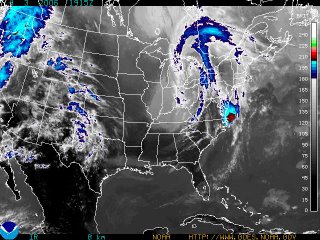
All good things must come to an end. Low pressure moving through Ontario today will spawn a second storm near Delmarva tonight. (See the red along the east coast above) This system will move north with moisture and at the same time colder air will sink south into upstate NY and New England. Tonight's rain will change to snow over higher elevations with 6 inches possible by Thursday. Along the valleys just a few flurries are expected at this time. It will however be windy and about 40 degrees F colder than last Friday! Stay tuned!
No comments:
Post a Comment