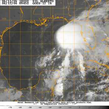
Alberto heads for Florida
As with the 2005 season, 2006's season has started early. An area of low pressure west of Cuba has moved into the Gulf of Mexico and become the first tropical system of the seaso. Alberto is a minimal tropical storm with 50mph winds this morning. While the storm will be a big rain maker for the Florida peninsula it is not expected to reach hurricane status at this time. The storm is forecast to drift across the state today and tonight before moving into the Atlantic Tuesday. It will then take aim at the Carolinas. At this time the worst of the weather may remain offshore for the Outer Banks.
I have just returned from two weeks on Hatteras Island in Avon, NC, so I am really hoping the dire predictions for this Hurricane season do not materialize. The island is 50 miles long by 1/2 mile wide and is 25 miles from the mainland. It has a rich history of storms, most recently Ophelia in 05 and Isabel in 03.
In any event rain and gusty winds are occurring across Florida's west coast this morning. Winds have already gusted to over 60mph in squalls along the coast. A Tropical Storm Warning is in effect for the west coast of the state including Tampa Bay. More info can be found at www.hurricanecity.com
The next update will be around 4pm today......
No comments:
Post a Comment