Tropical Storm Beryl
heads for Nova Scotia
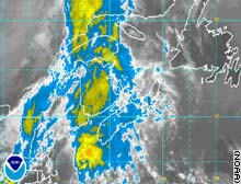
• The northern edge of Beryl is beginning to affect the southern coast of Nova Scotia as well as New Brunswick. Forecasters are expecting the storm to dump over 50mm of rain in the area along with gusty winds. This is the second named storm of the young Atlantic Hurricane season, we had 5 at this time last season. The storm will rapidly lose its tropical nature as it moves northeast into the Atlantic Ocean.
• Beryl brushed across Eastern Massachusettses with rain and wind but nothing more than that last night.
• It was hot this week in Kemptville. I recorded a max temperatures of 36C on Monday. The official reading was 33C at the MNR building.
• Hydro workers in Ontario continue to restore power to the more than 100,000 customers that lost it from Lake Superior to the Quebec border on Monday. The thunderstorms lashed the area with 100km/h plus winds and heavy rain. Two tornadoes were reported in New Market and numerous trees, some as old as 100 years, were flattened on Manitoulin Island. One death was reported from Monday's storms in Ontario.
• Glasgow, Montana did not reach 90F on Wednesday marking the first day since July 4 that it failed to do that. It was the 5th longest stretch of 90 degree plus weather since records began. The area along with most of western Canada and the Pacific Northwest will remain under intense heat again this week with temperatures approaching 100F (37C) in many areas.
• The Kemptville "bubble" remained in place last night. While many areas continue to see thunderstorms, parts of the Highway 43 corridor from Merrickville to Kemptville continue to miss out. The storms part as they approach the area going north into Ottawa or south into New York State.
No comments:
Post a Comment