 |
| Bermuda weather radar showing the eye of Gonzalo nearing the tiny island (plus sign) this afternoon. |
There is plenty to talk about this morning, so I am putting the Hurricane Hazel column off for a few hours. Lets start in Ontario and Quebec where very warm and moist air produced lots of heavy rain on Thursday. The rain along with tons of falling leaves clogged sewers across Toronto producing lots of flooding. The flooding disrupted the evening commute in what is becoming an all too familiar occurrence. Underpasses were flooded with motorists stranded. In addition several subway stations took on water as well. Pearson Airport recorded only 5.2mm on Thursday but other locations in the GTA had between 50 and 100mm (2-4 inches) of rain in just a few hours. It was the same in southern Quebec with Trudeau Airport recording 8mm of rain, but I managed 15mm here on L'Ile Perrot and amounts ranged over 25mm (1 inch) in other parts of the region as thunderstorms occurred.
 |
| Flooding from heavy rain in portions of the GTA late Thursday. (Toronto Star) |
Showers will continue today and into the weekend in Montreal as it turn sharply colder. Temperatures were in the low 20's again on Thursday but will drop to the teens today (17C) and single digits by Sunday when the high will only be 8C (47F).
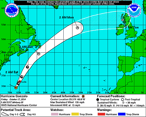 |
| The latest National Hurricane Center forecast has Gonzalo coming very close to eastern Newfoundland early Sunday. |
HURRICANE GONZALO
Gonzalo remains a major hurricane this morning with winds up to 130mph and a pressure of 946mb. The storm is located 240 miles (385km) south southwest of Bermuda while moving north northeast at 15mph. On this present course the hurricane will arrive very close to Bermuda late today. Winds at 7:30 were already over 60km/h (38mph) on the island. Heavy rain, in excess of 150mm (6 inches) along with dangerous winds and a powerful storm surge will arrive shortly. Once the storm moves past Bermuda it will begin to slowly weaken and transition into a powerful post-tropical storm. Winds and rain will begin to affect Atlantic Canada coastal waters by Saturday afternoon. It is still early to pinpoint the exact impact on Newfoundland, but heavy rain is likely along the southeast coast along with heavy surf. High surf is also forecast for Nova Scotia. Strong winds may impact the Avalon Peninsula if Gonzalo makes landfall in Newfoundland. The current NHC track has the storm remaining offshore.
No comments:
Post a Comment