 |
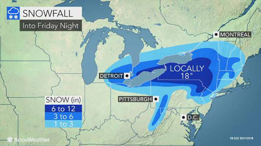
| So close and yet so far. Southern Quebec will remain on the northern edge of another coastal storm. Only flurries and strong winds are forecast Friday for Montreal. (AccuWeather.com) |
Tonight, the bulk of the heavy wet snow will fall from Windsor, Ontario eastward into the Niagara region as well as the Adirondacks. A general 10-30cm of snow is expected. Strong winds will gust over 50km/h, producing poor visibility. On Friday, the axis of heaviest precipitation will occur across New England and the northeast. Southern Quebec will remain on the extreme northern edge of the storm, with flurries and strong northeast winds developing Friday. Wind gusts may exceed 70km/h in the St. Lawrence Valley. The clouds and gusty winds will hold temperatures either side of 0C (32F) through Friday. Any snow accumulations will be in the order of 2cm, and confined to the regions south of Montreal.
Damaging Storm
Along the southern and eastern New England coastlines, residents are preparing for a major storm. Winds are expected to gust to hurricane force, 75mph or higher. Coastal flooding will be a major concern as the storm slowly moves into the Atlantic. Three successive high tides are expected during the duration of the storm, each pushing a tremendous amount of water onto the coast. Evacuations may be needed in several locations. Severe coastal impacts are expected. In addition to the wind and waves, 50 to 100mm (2-4 inches) of rain is possible. Widespread power outages are likely. The hardest hit area at this time is expected to be along the Massachusetts and Rhode Island coast.
No comments:
Post a Comment