 |
| Freezing rain warnings are in effect for a large portion of eastern Ontario and southern Quebec today and tonight. Freezing rain should start in Montreal by late this afternoon. |
Another messy winter storm is set to impact southern Quebec over the next 24 to 36 hours. Low pressure over the American Midwest will move into the Great Lakes and down the St. Lawrence Valley on Wednesday. In advance of the storm, colder air has settled back into Montreal. Temperatures early Tuesday morning are either side of -10C (14F).
Deep moisture will begin to stream northward later today, overriding the cold air at the surface. The result will be a few hours of freezing rain, starting this afternoon in eastern Ontario and the Ottawa Valley and spreading north and east into Quebec. Several hours of freezing rain are expected, with 5 to 10mm of ice accretion. Expect very slippery roads and sidewalks as well as the risk for isolated power outages in areas the see the longest duration of freezing rain such as Ottawa and Quebec City.
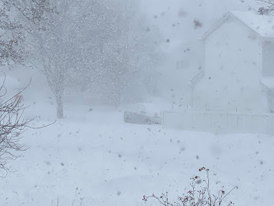 |
| It has been a rather busy weather week in Montreal. On Saturday, wicked snow squalls crossed the region, with rapidly falling snow and wind gusts over 70km/h. Visibility was reduced to zero at times as shown above on Ile Perrot. Numerous accidents and road closures resulted across southern Quebec. (ValleyWeather Photo) |
Temperatures will rise above freezing in Montreal overnight, as warm as 8C (47F) in areas along and south of the St. Lawrence River. Any freezing rain will change to showers in Montreal. A trailing cold front will follow on Wednesday, dropping temperatures just a quickly, down to -10C by late in the day. Winds will become quite strong on Wednesday, gusting up to 60km/h at times. Any remaining precipitation will taper off to flurries.
Another winter storm will slip south of the region on Friday, with a general 5 to 10cm of snow expected at this time for Montreal.
No comments:
Post a Comment