Thursday, May 29, 2025

Another dreary Saturday on tap for Montreal

A pop-up thunderstorm moves into the Montreal burrough of Saint-Laurent on the afternoon of Monday, May 26. The storm produced torrential rain, hail and lighting. Fortunately the cell was fast moving and as a result the impacts were minimal. Monday was the 11th consecutive day with measurable precipitation at Trudeau Airport. (Valley Weather)

Wednesday may have been the nicest day in May. Widespread sunshine allowed the temperature to rise to 27.4C (81F) at Trudeau Airport in Montreal. It was a rare moment in what has become a dull and wet spring. In May to date, 111.2mm of rain has fallen, that included precipitation on 11 consecutive days up to and including this past Monday. It has rained on 19 of the 28 days so far this month.

On Monday, some decent isolated, pop up thunderstorms put down heavy rain, lots of lightning and even some small hail during the afternoon hours. All the moisture has had at least a positive impact on the fire season in southern Quebec. There are only three active fires in the province at this time. Such is not the case elsewhere in Canada where massive wildfires have resulted in evacuations across parts of Manitoba and Saskatchewan.

The trend of unsettled weekend weather across southern Quebec will continue as we head into June. A weak warm front will lift north on Thursday, introducing some humid air. Spotty showers are possible into Friday. On Saturday, another unseasonably strong Nor'Easter will move north into New England, with abundant Atlantic moisture. At this time, it appears that Montreal and the Ottawa Valley will remain on the western edge of the storm. While heavy rain is expected in Vermont and the Eastern Townships on Saturday, Montreal should only have scattered showers and gusty northeast winds. Sunday should be partly cloudy, with perhaps a shower or two and milder temperatures.

Highs from Thursday into Sunday will drop into the upper teens from Wednesday's summer warmth. Lows will be in the lower teens. Briefly looking ahead to next week, we can expect warmer, but also a more humid airmass to arrive. As a result showers and thunderstorms will remain a real possibility in the St. Lawrence Valley.

Thursday, May 22, 2025

Late season nor'easter to bring gusty winds and a cold rain to Montreal

It has been a dull and dismal weather week across Sothern Quebec, with frequent rain, chilly north or northeast winds and low temperatures.

Heat and sweaters have replaced shorts and air conditioners this week across southern Quebec as unseasonable cold air remains stalled over the region along with clouds and occasional rain. 

A late season nor'easter is strengthening off the middle Atlantic coast on Thursday, set to move northeast towards Cape Cod. The storm combined with low pressure spinning over the Great Lakes, will maintain the dismal weather Montreal has been experiencing this week. All across southern Ontario and Quebec, grey skies, occasional showers and a relentless cold north wind have been making May feel more like late March.

Nor'easters are strong ocean storms that develop along the eastern seaboard, and usually bring Montreal some of our larger snowstorms. They are more common during the colder months as opposed to May.

For the near-term, we can expect three more days of showers, along with gusty northeast winds up to 50km/h. Daytime highs will struggle to reach 12C (54F) with cold overnight lows in the 5C to 7C (40 to 45F) range. The normal high should be 21C (70F). The gusty winds will make it feel even colder outdoors.

It could be worse. Closer to the storm center along the southern New England Coast and into Atlantic Canada, heavy rain will fall, with up to 75mm possible. Winds may gust over 90km/h, producing some coastal flooding. Temperatures are so cold, that some of the highest elevations of Vermont, New Hampshire and Maine into the Beauce region southeastern Quebec may see some snow accumulate during the overnight hours.

Conditions will try to improve on Sunday. We may see some clearing and slightly warmer temperatures. Unfortunately long-term trends continue to show wet weather to end the month. To date 77.4mm of rain has fallen this month. Since January 1st, some form of precipitation has fallen on just about every weekend, with the exception of two or three at best. This weekend looks no different at the moment.

Monday, May 19, 2025

Clouds, cool and wet weather to linger in Montreal

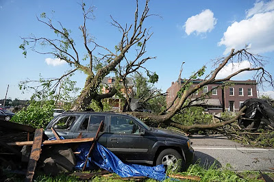
A stubborn weather pattern is resulting in dismal weather here in southern Quebec, while producing rounds of severe thunderstorms across the central United States. The damage above occurred with a strong tornado in St. Louis, Missouri on Friday. The storm resulted in significant damage and sadly the loss of 5 lives. The death toll stands at 33 from the weekend storms. (CBS)

Montreal is in the midst of a long stretch of rather dismal weather. It is a very chilly morning in the city, with 8C (48F) here in Ile Perrot. The temperature will not budge today, under persistent clouds and northerly winds, we may see 10C (50F) if we are lucky. Expect a few showers as well.

The forecast does not look good the balance of the week, with a persistent northerly flow of cool, moist air expected. Look for clouds and showers right into next weekend, along with well-below normal temperatures. Daytime highs will rage in the low to middle teens, with overnight lows from 7C to 10C (45-50F). Warm weather is expected to return to southern Quebec for the last week of May.

As far as precipitation is concerned, another 10-20mm of rain is possible by the weekend. I measured 33.2mm here on Ile Perrot since Friday afternoon. The bulk of that occurred during thunderstorms Saturday morning. May is definitely been wet, with 77mm falling as of Sunday at Trudeau Airport, with 69.2mm here on Ile Perrot. 

The culprit has been a strong upper level low slowly drifting from the central Great Lakes Friday into northern New England on Monday morning. The result has been waves of rain and much colder temperatures. In advance of the low, we managed a muggy 29C (85F) on Friday before strong thunderstorms arrived on Saturday. Those storms produced mostly heavy rain here in the Montreal region, with plenty of lightning. Other parts of southern Quebec reported hail and there was flash flooding in Sherbrooke after 50-70mm of rain fell in just a few hours.

A submitted photo to The Weather Network from a resident of Howick, Quebec, showing the potential tornado on Saturday evening. Environment Canada is investigating. (TWN)

South of Montreal near Howick, there was report of a weak tornado around 7:30pm Saturday evening, There was no damage observed, and Environment Canada is investigating to determine the strength of the storm. The strong storms also produced widespread severe weather in Vermont, with flash flooding, downed trees and large hail.

The same weather setup is delivering rounds of severe weather across the central portion of the United States. The weekend death toll stands at 33 from persistent and long lasting tornadoes across several states. The hardest hit region stretched from Missouri to Kentucky. A powerful storm killed 5 in St. Louis on Friday, while London, Kentucky was leveled on Saturday. In Kentucky, 19 deaths have been reported so far, with scores of injuries and widespread damage.

Another round of strong storms is forecast on Monday for parts of the southern plains from Colorado and Kansas into Texas and Oklahoma.

Thursday, May 15, 2025

Thunderstorms - cooler weather on tap for Montreal

Day turns to night as a 3000 hectare wildfire burns out of control south of Wendigo Beach in Manitoba on Wednesday. Unseasonably hot weather has fuelled the massive wildfire near Lac Du Bonnet in the eastern part of the province. Some relief is sight as rain and much colder weather arrives late this week. (Photo: Manitoba Hydro)

The warm weather will continue in Montreal for a few more days, with a noticeable increase in humidity levels as we head into Friday. A large upper level low spinning across the northern plain states, will move across the Great Lakes and slowly into Quebec this long Victoria Day holiday weekend.

In advance of the low, a warm southerly fetch of moist air form the Gulf of Mexico will push high temperatures once again into the upper 20s across southern Quebec. On Wednesday, Quebec and New Brunswick were the warmest spots in Canada. Montreal reached 27.4C (82F), the normal high for mid May should be around 20C (68F). Other parts of the region were even warmer, close to 30C. Roberval in central Quebec reached 31C (88F). In New Brunswick, six record highs were established for the date, including 31.8C (89F) at Edmunston.

The warmer more humid air on Friday will lead to the development of widespread afternoon showers and thunderstorms, with some locations receiving as much as 25mm (1 inch) of rain. The moisture will be welcome.

The aforementioned upper level low will result in much colder weather arriving in Montreal by Sunday. After the thunderstorms and warm weather on Friday, Saturday will be a transition day, with rain and windy conditions expected. Highs in the 20s, will drop by Sunday and Monday into the middle teens along with gusty west and northwest winds.

Manitoba Wildfires

The unseasonable heatwave that has been impacting southern Manitoba and Saskatchewan has lead to significant and early start to the wildfire season. The Lac Du Bonnet fire in eastern Manitoba has reached 3000 hectares, one of 24 burning in that province. The fire has resulted in the evacuation of over 1000 residents, destruction of property and sadly two fatalities. The fire has been fuelled by days of record-breaking heat, reaching 37C (100F) at times. Dry weather and strong winds have moved the fires along quickly. Relief is in sight as much colder weather and rain are forecast over the next 48 hours. Unfortunately strong winds are expected as well, gusting up to 80km/h.

Monday, May 12, 2025

Summery weather week ahead for Montreal

Sunshine returned to Montreal on Sunday after 24mm of rain fell Friday and Saturday in the city. The warming temperatures and precipitation have finally allowed the trees to begin leafing out in southwestern Quebec. Unfortunately along with that comes pollen and seasonal allergies.

Skies are clearing Monday morning across southern Quebec, as a weak warm front lifts north of the St. Lawrence Valley. This will set the stage for a very warm week ahead, with temperatures reaching summery levels for the first time this season.

We can expect mostly dry weather through Thursday, but we can't rule out an isolated sprinkle or rumble of thunder, especially mid week. The best change should remain southwest of Montreal over upstate New York and eastern Ontario.

High temperatures will start in the lower 20s Monday, 21C (70F) here in Montreal, and gradually rise into the upper 20's (lower 80s). Overnight lows will remain very mild for early May, in the middle teens.

Unfortunately there will be some changes in the weather by the long Victoria Day weekend. Low pressure will move across the Great Lakes by Friday, with a more humid fetch of air moving northeast from the Gulf of Mexico. This will likely lead to some decent showers and thunderstorms by Friday, persisting into the weekend.

By Saturday, we can also expect some cooler air to move into Montreal on the back side of the aforementioned low pressure, as it moves into central Québec. Temperatures will lower into the upper teens for daytime highs by Sunday.

HEATWAVE

Central portions of the United States from the high plains into extreme southern Manitoba are experiencing an unprecedented early season heatwave. On Sunday, the temperature reached 37.8C (100.4F) at Emerson and Dominion City, Manitoba, shattering the previous record of 30.9C (87F) set just last year. The normal high for early May is only 20C (68F). Another indication that we are seeing some significant early season warming in Canada in recent years. This was one of 9 new temperature records established in the province. Southern Saskatchewan also reported record breaking heat. Heat warnings are in effect again Monday, with another round of mid to upper 30s forecast. Winnipeg is expecting a high of 35C (95F) on Monday.

Friday, May 09, 2025

Flood concerns on the rise across southern Quebec

Several municipalities in southwestern Quebec are monitoring area rives for potential spring flooding. At this time, only minor impacts are expected. If you live in a flood-prone area, remain vigilant. (Valley Weather Photo)

Some rivers in southwestern Quebec have reached minor flood stage, but the threat is relatively low at the time, with any flooding confined to the immediate shoreline and low-lying areas.

Several waterways in the region are being observed for minor flooding as runoff from the upper Ottawa Valley makes it's way into southwestern Quebec. They include the Ottawa, Rigaud, des Milles Iles and des Prairies Rivers.The good news is that it has been a relatively dry spring, void of any big storms. Rain is forecast Friday and Saturday, but the heaviest precipitation should remain over New England.

At this time several municipalities, including Pierrefonds, Senneville and Ile Bizard have started to prepare in the event of flooding. This includes preparing sandbags, pumps, flood gates and temporary muscle walls. The Village of Senneville has moved into Intervention 2 mode. They have made sandbags available to residents and have established a call centre.

Most computer models have the heaviest rain from this weekend's storm remaining over New England. The GFS is forecasting 18mm for Montreal by 1pm Saturday, with more over the Townships. (Ventusky)

In the province, 12 waterways are under surveillance by Sécurité Publique Québec, with 10 additional waterways in minor flood stage. They include the Ottawa and Rigaud Rivers, as well as Lac des Deux Montagnes. In the latter caae, the level is now at 23.37 metres, minor flood stage is reached at 23.30 metres. In all cases, water levels are fairly stable and well below the historic spring flooding in 2017 and 2019.

Developing low pressure Friday east of the middle Atlantic will move along the eastern seaboard into Maritimes over the weekend. A chilly rain and gusty northeast winds will develop in Montreal Friday, with 10-20mm possible by late Saturday. Much heavier accumulations, in the order of 25-50mm (1-2 inches) are likely in the Eastern Townships, with amounts reaching 75mm (3 inches) over Vermont. A flood watch is in effect in southern Vermont.

The good news for our region is that the Ottawa River basin will be on the far western edge of this storm system, with very little precipitation expected in those locations. Additionally, high pressure will build into the region starting Sunday, with warm and dry weather forecast next week through Wednesday. This will allow water levels to stabilize and even lower in most cases.

Remember, if you live in areas prone to river and spring flooding, remain vigilant and listen to what local authorities and municipalities are advising. Many municipal websites have sections dedicated to spring flooding, with information and contact numbers.

Wednesday, May 07, 2025

Summer warmth on the horizon for Montreal

Like a mountain range in the sky, dark clouds loom on the western horizon Wednesday morning, as an upper level low over Ontario moves into southern Québec. So far most of the chilly weather and heavy rain has remained in eastern and central Ontario. (Valley Weather Photo)

I must admit, I was wrong on the chilly weather forecast so far, as temperatures this week have over performed to this point. Montreal recorded a high of 24C (76F) on Tuesday, as skies cleared from morning rain, and the bulk of the afternoon thunderstorm activity remained to our west over Ontario. An upper level low, part of a larger omega block, has been stuck over the Great Lakes all week. Areas that have been receiving rain, have received quite a bit, in the order of 50mm. Here in Montreal, close to 15mm fell, but it was less than I expected, and temperatures have been warmer.

Radar Wednesday morning showing heavy precipitation from an upper level low spinning over parts of southern Ontario. The bulk of the rain has missed Montreal so far, with only 15.4mm falling so far this month, most of that occurring in the pre-dawn hours Tuesday morning.

As I write, the clouds are playing with the sun, in advance of the low pulling across southern Quebec and dragging a cold front along. Showers, with perhaps a rumble of thunder are likely Wednesday afternoon, before precipitation ends this evening and temperatures fall.

Thursday through Saturday will be partly to mostly cloudy, but fairly dry for southern Quebec. There is a risk of a few spotty showers and temperatures will be much cooler. Morning lows Thursday will drop into the upper single digits, with highs struggling to reach 13C (55F).

The good news is that much warmer, more summer-like weather is on the immediate horizon. High pressure will slowly drift across the region starting Sunday into next week. Highs will be in the lower 20s, Sunday but warming up to 28C (83F) for Monday and Tuesday. Some much needed sunshine is expected.

First Quebec Tornado for 2025

The Northern Tornadoes Project from Western University in London, Ontario finished their survey of damage caused by severe weather on April 29. They determined that outside of straight line winds here in the Montreal region, the first tornado of the season in Quebec occurred north of the St. Lawrence Valley at Saint-Zénon. The EF-1 tornado, capable of winds of up to 165km/h, moved along a 600 metre-wide path for 6.74 kilometres. The storm flattened trees, damaged barns and tore the roof from a home. It was the third tornado reported in Canada so far during this very young severe weather season. Thankfully there have been no injuries reported.

Monday, May 05, 2025

Unsettled, chilly weather week ahead for Montreal

A Hydro-Québec team repairs significant damage to utility lines on May 1st, after last Tuesday's thunderstorms caused widespread power outages across the Montreal region. Rumbles of thunder are possible this Tuesday and Wednesday from a cold upper level low, but outside of perhaps some small hail, no severe weather is expected at this time. (Hydro-Québec Photo)

The weather will not feel like May this week as a series of frontal boundaries and an upper level low combine to bring us a chilly damp week. Monday will be mostly cloudy, but with some breaks of sun, allowing temperatures to reach into the upper teens, perhaps 20C (68F). It will likely be the best weather day of the work week. 

Clouds thicken this afternoon and showers arrive Monday night into Tuesday, along with a few rumbles of thunder. Temperatures will remain mild through Tuesday evening, dropping to 11C (52F) and perhaps reaching 21C (70F) Tuesday. By Wednesday, and upper level low over the Great Lakes will move towards Quebec City, keeping a damp, chilly airmass in place over the St. Lawrence Valley. Temperatures will drop into the lower teens for daytime highs, along with cloud cover and occasional showers. Overnight lows will be in the single digits.

The aforementioned low will slowly drift into Atlantic Canada by the weekend, but may be replaced by another area of low pressure. While the week will not be a complete washout, the weather will certainly not feel very springlike. However as we have seen in the last week or so, it does not take much sunshine to push temperatures up quickly. We can only hope those breaks of sun will be more numerous than the forecast predicts.