Sunday, April 08, 2018

Chilly start to April to continue across most of Canada

I would like to express my deepest condolences to the residents of Humboldt and the province of Saskatchewan. I was saddened to hear the news of the terrible accident involving the Broncos hockey club. I wish the players, families and first responders strength and courage as they begin the long recovery process.

Strong winds in east end Montreal, toppled this sign onto several cars Wednesday night, April 4. The wind cut power to nearly 50,000 customers in Quebec. (Radio Canada Photo)
April Chill
The miserably cold start to April continues across most of Canada. From coast to coast, Canadians are dealing with cold and snow. The low on Friday morning in Edmonton was a bone-chilling -25C (-13F), the coldest since 1975. The storm on April 4 produced over 25mm of rain in Montreal, but the fierce winds were the real story. Gusts exceeded 90km/h in many parts of Ontario and Quebec, with a peak gust of 89km/h recorded at both Trudeau Airport and south shore St Hubert. In Ontario, the strongest wind was at Point Petre, at 102km/h. In New York, 75mph winds were recorded east of Lake Erie, while a gust to 100mph was measured on Mount Mansfield in Vermont.The wind knocked power out to thousands, including 50,000 in Quebec. There was also reports of structural and tree damage. Heavy snow fell northeast of Montreal, with 27cm at Quebec City. Blowing snow closed Highway 20 east of Quebec City to Riviere-du-Loup.

A tree lies across a house in western New York on April 4. (AccuWeather.com)
Cold, blustery weather followed the storm, with a high in Montreal of only -3C (27F) on Thursday, 4C (39F) Friday and a windy 3C (38F) Saturday. The average high for this time of year should be 9C (48F). Snow showers have been accompanying the cold, making it feel like February.

As we look ahead to the upcoming week, the picture looks the same for southern Quebec and Ontario. Expect below normal temperatures with periods of showers or flurries scattered through the week. At best, high temperatures may reach 7C (45F), still well below normal. Overnight lows will dip below freezing. At this rate, the icy piles of dirty snow still around, may last into May. I just want to rake my lawn!

Monday, April 02, 2018

Strong spring storm to spread snow and rain across Quebec

Where has spring gone? Many parts of Canada as well as the northern US continue to experience cold and snowy weather. More of the same is forecast through at least the middle of April.
Deepening low pressure is forecast to move from Colorado towards the lower Great Lakes on Tuesday. A warm front well in advance of the storm center, will push across the region Tuesday night, followed by a potent cold front Wednesday evening. South and east of the storm track, heavy rain is expected, with 25 to 40mm possible. Heavy rainfall warnings have been issued for southern Quebec, including metro Montreal. North and west of the track, snow will be the dominant precipitation type. Some locations from the upper Ottawa Valley into the Laurentians, may pick up 20 to 30cm of heavy wet snow. Environment Canada has posted snowfall warnings for Mont Tremblant as well as Sainte-Agathe and Saint-Sauvuer. Warnings are also in effect for the upper Ottawa Valley including Pembroke and Petawawa. Portions of western Quebec and extreme eastern Ontario may have mixed precipitation to start late Tuesday, but should transition to rain quickly. Behind the storm, rain will change to snow in Ottawa Wednesday night, with 5cm forecast.

Strong Winds
Temperatures will warm above freezing in Montreal on Tuesday, reaching a high of 4C (39F), with 6C (43F) expected on Wednesday. A strong cold front will arrive late Wednesday into Thursday morning, accompanied by very strong northwest winds. In the St. Lawrence Valley, gusts may reach 90km/h. Wind warnings may be necessary for Montreal late wednesday afternoon. Unseasonably cold air will rush back into southern Quebec, with lows plummeting by Thursday morning to -10C (14F) in Montreal. The cold, unsettled weather will be with us through the middle of the month, with several opportunities for snow across the northern tier of the US as well as central and eastern Canada. The next chance for snow could come as early as Friday morning here in Montreal, as a clipper system moves south of the city. More on that as the week progresses.

Thursday, March 29, 2018

Cold start to April still on tap for Quebec and Ontario

This large tractor seems rather small next to the dirty Dorval snow pile. The towering pile of snirt,  a Prairie term for a snow and dirt mixture, is slowly beginning the long melting process. This will likely last well into May or June. (ValleyWeather)
I am anticipating a mild end to the work week and the start of the upcoming Easter and Passover weekend. Low pressure will approach southern Quebec later today and into Good Friday, with plenty of moisture. Along with the moisture will come a surge of warm air. Expect temperatures to rise to 10C (50F) Thursday, and 7C (45F) Friday. Unfortunately there will also be plenty of clouds and 15-20mm of rain through Friday morning. In the wake of the system, slightly cooler air will arrive late Friday along with clearing skies.

On Saturday, a potent cold front will cross the area late in the day, along with much colder temperatures. The low by Easter Sunday morning will be well below freezing across the entire region. Some light snow or flurries will be possible as well. The high temperature on Sunday will be well below normal, only 0C (32F) for Montreal. Looking ahead to next week, much cooler air is anticipated along with several opportunities for some snow. Temperatures are expected to remain below normal into the second week of the month.

The cold air will extend into the southern Prairies, where record low temperatures are anticipated through Easter weekend. Snow and blowing snow is also forecast from Alberta into southern Saskatchewan, making travel difficult. The snow will extend into the Dakotas and Minnesota as well.

Thursday, March 22, 2018

Spring temperatures slow to arrive in Montreal

Clearing highways in eastern Maryland late Wednesday afternoon. A large area of arctic high pressure has dominated the weather over southern Quebec, keeping the east coast snowstorm shown above, well to our south.
(Maryland DOT Photo)
You must forgive me for actually missing the arrival of Spring this past Tuesday, March 20 at 12:15pm. I was too busy bundling up to walk the dog, in a biting northwest wind and near-record cold temperatures. The first day of spring continued the trend of well below normal temperatures that started late last week. Daytime highs and overnight lows have been running 10 to 12 degrees colder than normal, including the first multi-day freezing weather here in Montreal since February 12th and13th. The first day of Spring, the morning low was -13.5C (8F), missing the record low for the day of -17.8C (0F), set in 1949. That was at Trudeau Airport. Other locations off island were much closer to the record low, including on L'Ile Perrot, where I recorded -17C (1F).

The silver lining to this cold weather, is that the arctic high responsible for it, has been keeping the storm systems to our south and east. The latest nor'easter only sent high clouds across southern Quebec. The system dumped more heavy wet snow from Washington D.C into New York City, with up to 30cm in some locations. The fourth nor'easter in three weeks, send the region into the usual lockdown, with thousands of flights cancelled in anticipation of the snow. Schools and businesses were closed, and rail travel suspended in the northeast corridor.

Montreal can expect partly sunny skies, with moderating temperatures through the weekend, and into next week. High temperatures may reach 10C (50F) by next Wednesday.  A few weak impulses of energy may give southern Quebec a few flurries over the weekend, but no major accumulations are forecast through next week. By late next week into Easter weekend, colder air is forecast to return, along with increasing chances of some snow to start April. Adding to the chill, is the fact that the Great Lakes still have ice covering more than 30 percent of the surface, which may result in a delayed onset of warmer weather.

Thursday, March 15, 2018

The calm after the storm in Montreal

Where is Spring? Allard Avenue in Verdun early Wednesday morning. Over 20cm of wet snow has fallen across metro Montreal since late Tuesday.
(Photo J. Balena)
Low pressure is slowly relaxing its grip on southern Quebec late Thursday afternoon, with partial sunshine developing. This comes after 48 hours of what seemed like endless snow. Storm accumulations were very impressive across our area, with 20 to 30cm across metro Montreal, the highest snowfall as expected, occurring south of the city. The mountains of northern Vermont and New York were buried under several feet of snow over the last few days. A special weather statement from the National Weather Service in Burlington Thursday afternoon, even hinted at an elevated risk for avalanches in the region. Keep this in mind if you have ski plans this weekend. The most recent storm is slowly spinning across eastern New Brunswick, forecast to move out of the region on Friday.

In the wake of the storm, unseasonably cold air will begin to filter into Montreal. Skies will be partly cloudy on Friday, but it will be cold with overnight lows near -7C (19F) and daytime highs at -2C (28F). A cold front arrives Saturday, accompanied by snow flurries and perhaps some brief squalls. Much colder air will arrive behind the front on gusty northwest winds. The high Saturday will be -5C (23F), with an overnight low of -16C (3F). Sunday will remain breezy and cold, with a very slow moderation in temperatures. After the mild weather of the last few weeks, this cold snap will feel brutal. As we look ahead to next week, a fourth coastal storm is expected to develop by late Tuesday and possibly impact New England. At this time it is too early to tell if we will experience any weather form the system.

Tuesday, March 13, 2018

Storm to bring 10 to 25cm of snow to southern Quebec

The third storm in the last two weeks is producing heavy snow in New England on Tuesday. (Cohasset Police Photo)
Snowfall Warning in effect for Vaudreuil/Dorion, Eastern Townships/Beauce

The latest in a series of east coast storms is pounding New England Tuesday afternoon with heavy wet snow and strong winds. The strengthening storm was located east of Cape Cod at 2pm, forecast to move northeast towards Nova Scotia before curling northwest into eastern Quebec on Wednesday.

Snowfall warnings are now in effect for Vaudreuil/Dorion southward to the US border. Warnings have been posted for the Eastern Townships and Beauce regions as well. Widespread storm warnings are also in effect across New England and New York. A special weather statement is covering the snow in southeast Ontario. Travel will become poor across the entire area later today and especially tonight.

Light snow has already fallen across southern Quebec Tuesday, but is expected to intensify this afternoon and tonight, as a trough of low pressure draws moisture inland form the coastal storm. Heavy wet snow Tuesday tonight and Wednesday will accumulate 10 to 15cm in Montreal, with 15 to 25cm across the warned regions south of the city. The highest accumulations will be found across the higher elevations, with some melting occurring in the city. Strong northeast winds are also forecast to develop, gusting between 30-60km/h in the St. Lawrence Valley through Wednesday. The temperature will remain steady through the period, between 1C and -1C (28 to 33F). Light snow is expected to persist into Thursday.

Consider postponing non-essential travel south and east of Montreal tonight.

Monday, March 12, 2018

The parade of storms continues for the east coast

Montreal will be on the western edge of another coastal storm this week. Snow may accumulate 10 to 20cm over a 48-hour period starting Tuesday.
The third Nor'easter in the last ten days is poised to take aim at New England this week. Low pressure is expected to develop off the Carolina coast on Monday, and rapidly deepen as it moves east of Cape Cod on Tuesday. Following a track very similar to the previous storms, the bulk of the snow is expected to fall across southern and eastern New England, southeastern Quebec and portions of Atlantic Canada. Strong winds and pounding surf are forecast for the same regions that are still trying to restore power and repair coastal infrastructure. As far as snow goes, 20 to 40cm (8 to 16 inches) is likely, across the far Eastern Townships south and east into New England.

Long-duration snowfall for Montreal
Once again, the current track keeps Montreal and eastern Ontario on the western periphery of the heaviest precipitation. However, this time, an upper-level low over the Great Lakes will draw moisture from the coastal storm into southern Quebec starting Tuesday. A long-duration snow event is expected, with periods of light snow lasting into Thursday. This is a very complicated setup, and combined with the warming March sun, makes amounts difficult to predict for Montreal. For example, I anticipated more snow last week, but the heaviest amounts remained east of the city. What did fall melted very quickly. If I had to estimate accumulations at this time, they would fall into the 10 to 20cm (4 to 8 inches) range for southern Quebec. As with last week, given temperatures near the freezing point, this may be generous. We will have to keep a close eye on the exact track of the storm and how quickly cooler air is pulled in behind the storm this week. This forecast is subject to major adjustments... stay tuned!

Thursday, March 08, 2018

Nor'easter buries New York, New Jersey & New England

Heavy snow piles up in Morristown, New Jersey Wednesday night. The second storm in less than a week, dumped over 60cm (2 feet) of heavy wet snow on the region. The system has largely avoided southwestern Quebec so far, with only a few centimetres falling. (Photo: The Weather Channel)
The second nor'easter in less than a week buried portions of the east coast on Wednesday. Heavy wet snow fell from Pennsylvania across New Jersey and New York and into New England. The hardest hit regions were from southern Vermont across the lower Hudson Valley into central New Jersey, where as much as 70cm of snow fell. In some locations, the snow was falling at more than 10cm (4 inches) per hour late Wednesday. Thunder, lightning and strong winds accompanied the snow. As of Thursday morning, nearly 750,000 homes and businesses were without power in New England and the Northeast. Air and rail service have been greatly impacted from Washington to Boston. Several highways are closed due to multiple accidents, downed trees and power lines and deep snow.

The storm responsible for all the weather is now moving into Maine, likely to deliver 10 to 30cm of snow to portions of New Brunswick and eastern Quebec. A last minute wobble of 30 to 50 miles to the east, managed to spare Montreal any real impacts from the system so far. As of 7am this morning, I had measured 2 to 3cm of snow on L'Ile Perrot. As the storm moves into New Brunswick, it is expected to weaken today and retrograde westward towards Montreal by late Friday. What this means locally, is intermittent light snow throughout Thursday and Friday, perhaps persisting into Saturday. Accumulations may reach 10cm in many regions of southern Quebec, including metro Montreal, but falling over a 36 hour period, I am not expecting any major impacts. Winds will be gusty in Montreal on Thursday, out of the northeast 30-50km/h. Expect temperatures to remain either side of 0C (-2C to +1C) over the next 36 hours.

Wednesday, March 07, 2018

East coast storm to impact Montreal & southern Quebec

Montreal will remain on the extreme western edge of the latest coastal storm. (AccuWeather.com)
As municipal and utility crews, including Hydro Quebec, continue the massive clean up form last Fridays's storm, another is taking aim at the east coast. Power is still out for many, with the second storm excepted to hit today. Low pressure is developing Wednesday morning, east of New Jersey. This system is forecast to strengthen rapidly and move across Cape Cod and into Maine on Thursday. Another round of strong winds and heavy surf is expected for coastal communities still reeling form the last storm. A wide area of precipitation is spreading north this morning, expected to arrive in southern Quebec and Montreal by the evening commute.

Widespread winter storm warnings are in effect for all of New England and eastern New York, extending into southeastern Quebec, including the Townships, through Thursday evening. A special weather statement covers the snow forecast from Montreal south to the American border. If the forecast track remain accurate, Montreal will be on the edge of the heaviest snow, with 5-10cm (2-4 inches) likely in the city, and 10-15cm (4 to 6 inches) form Vaudreuil south into New York. Southeast of Montreal along Highway 10, expect heavier snow, with 15-25cm (6-10 inches) possible by late Thursday. Travel in that region is not advised. The snow for all regions will taper to flurries late Thursday, and persist into Friday as the system slowly weakens and moves into Quebec.

Winds will be another factor with the snow, especially here in the St. Lawrence Valley, where they will gust over 50km/h. The temperature throughout the storm should remain fairly steady in Montreal, between 0C and -2C (28 to 32F).

Monday, March 05, 2018

Next coastal storm to impact southern Quebec

Hydro Quebec crews are currently on the ground in southern New York, helping restore power to some of the nearly 2 million homes affected by last weeks storm. (Twitter @HydroQuebec)
We have a very active weather week ahead for southern Quebec and New England. I will start by taking a brief look back at the storm that just left us. The powerful nor'easter pounded the southern New England coast with heavy surf and widespread coastal flooding. Strong winds, gusting over 120km/h brought down thousands of trees and power lines from the Carolinas to Maine. At the height of the storm, over 2 million homes and businesses were without power. Hydro Quebec was contacted in advance of the storm by local utilities, and responded with 108 teams, comprising 220 employees. The teams are scattered around New England, but are mostly located along the souther tier of New York state, near the Pennsylvania border. This region received over two feet (60cm) of heavy wet snow. Infrastructure took a big hit in coastal communities, including Hampton Beach, New Hampshire, where roads were washed out. Further south in Massachusetts, beaches were swept away and numerous homes damaged. Seven deaths were blamed on the storm.

Powerful winds and pounding surf caused widespread damage from New England to the Carolinas. The photo above was taken in Tewksbury, Massachusetts. (Tewksbury Police Photo)
Over the weekend, what was left of the system, drifted into the Atlantic, but had enough moisture left over to interact with an upper level disturbance over southern Quebec and eastern Ontario. As a result, cloud cover dominated our weather, along with light snow. Some locations reported as much as 5cm of wet snow.

The next storm is on the horizon, expected to produce heavy snow for many regions of Quebec. (AccuWeather.com)
Looking ahead to this week, another major system is forecast to develop on Thursday along the east coast. This system will not be as strong as last weeks storm, but still have an impact on our weather. Depending on the exact track and proximity to the coast, some locations in southern Quebec may have a significant snowfall. At this time, the heaviest snow, in excess of 20cm (8 inches), will likely fall across the Townships, areas near the US border and in New England. Winter storm watches are already in effect across upstate New York and most of New England.

Snow will arrive in Montreal early Thursday and persist into Friday. I am thinking a general 10cm is likely for Montreal, but that is subject to change. Look for updates throughout the week as the picture becomes clearer regarding this storm.

Thursday, March 01, 2018

Powerful coastal storm to graze southern Quebec

So close and yet so far. Southern Quebec will remain on the northern edge of another coastal storm. Only flurries and strong winds are forecast Friday for Montreal. (AccuWeather.com)
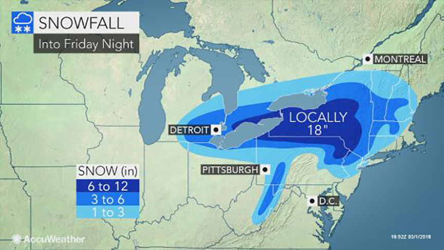
Strengthening low pressure will slide across the state of New York overnight, delivering heavy snow and strong winds from Michigan into southwest Ontario and New York. The storm will move off the New Jersey coast on Friday and rapidly deepen into a major Nor'Easter.

Tonight, the bulk of the heavy wet snow will fall from Windsor, Ontario eastward into the Niagara region as well as the Adirondacks. A general 10-30cm of snow is expected. Strong winds will gust over 50km/h, producing poor visibility. On Friday, the axis of heaviest precipitation will occur across New England and the northeast. Southern Quebec will remain on the extreme northern edge of the storm, with flurries and strong northeast winds developing Friday. Wind gusts may exceed 70km/h in the St. Lawrence Valley. The clouds and gusty winds will hold temperatures either side of 0C (32F) through Friday. Any snow accumulations will be in the order of 2cm, and confined to the regions south of Montreal.

Damaging Storm
Along the southern and eastern New England coastlines, residents are preparing for a major storm. Winds are expected to gust to hurricane force, 75mph or higher. Coastal flooding will be a major concern as the storm slowly moves into the Atlantic. Three successive high tides are expected during the duration of the storm, each pushing a tremendous amount of water onto the coast. Evacuations may be needed in several locations. Severe coastal impacts are expected. In addition to the wind and waves, 50 to 100mm (2-4 inches) of rain is possible. Widespread power outages are likely. The hardest hit area at this time is expected to be along the Massachusetts and Rhode Island coast.

Wednesday, February 28, 2018

Has spring arrived in Montreal?

Lac St. Louis remains locked in ice February 28, 2018. However, with above-normal temperatures during the last two weeks and more mild air expected for the next two weeks, the ice should begin to thin and break up soon. (ValleyWeather Photo)
Meteorological winter will come to an end today, February 28. In Montreal, it was an interesting winter, to say the least, but is it over? February started off cold and snowy, with expectations of that weather lasting the entire month and well into March. Mother Nature, however, had a different plan, with a large warm ridge of high pressure dominating eastern North America. A persistent western trough managed to keep the cold air locked in place across the Prairies, Alberta and B.C. For Montreal, the average high for February was -0.2C, well above the normal of -3.2C. The temperature was above the freezing mark on 15 of the 28 days. In the last two weeks, daytime highs have been anywhere from 5 to 15 degrees above normal on most days. The two factors keeping our highs lower than they may have reached were the 207cm of snow that fell on Montreal from December through early February and the frozen St. Lawrence River.

Is the warm weather here to stay?  The short answer: yes. Looking into our "crystal ball", no frigid air is expected for at least the next two weeks. At that point, being well into March, the angle of the sun is increasing, making it rather difficult for arctic air to become established.

Just how warm has it been overall this February? Well in Greenland, February high temperatures have been running well above normal. At Cape Morris Jessup, in the high Arctic region of northern Greenland, the temperature has been above freezing for 61 hours this winter. The Arctic winter runs October to March, with much of the region in complete darkness. The 61 hours establishes a new record, smashing the old record of 16 hours set in 2011. The warm weather included 24 consecutive hours above freezing on February 20th and a high of 6C (43F) on February 24. This shows us just how little cold air is available across eastern North America. These numbers should be a real concern to all of us. They are startling. While above-freezing winter temperatures do occur, on average, once a decade at this location, this is the second time in the last three years, and never for such an extended period. Arctic sea ice is melting faster than anyone expected.

With all of this information taken into account, and peeking at the models over the next few weeks, spring may have indeed arrived in Montreal. However, that does not rule out a quick-hitting storm or two. As we are all well aware, historically, the largest snowstorms in Montreal have occurred in March and even into the early part of April.

Friday, February 23, 2018

Messy weather weekend ahead for southern Quebec

Freezing rain warnings are in effect for Montreal, The St Lawrence and Ottawa Valleys through Friday night.
A freezing rain warning in effect for Montreal, southern Quebec and eastern Ontario through midnight Friday.

A period of very mild and wet weather is expected this weekend across southern Quebec. The warm air will remain in place next week, with temperatures expected to be well above normal. Montreal will remain on the warm side of two winter storms moving from Colorado towards the western Great Lakes over the weekend. The first system will spread clouds and light freezing rain into southern Quebec this afternoon. Freezing rain warnings are in effect for Montreal, but the precipitation should be fairly light. We can expect 2 to 5mm of freezing rain, changing to showers this evening as the temperature warms to 3C (38F) overnight.

Saturday will feature clearing skies and mild temperatures, with no precipitation expected. On Sunday, the stronger of the two storms will follow a similar path across the central Great Lakes towards James Bay. With a forecast track well north and west of Montreal, warm air will dominate in our region once again. Snow mixed with freezing rain will begin Sunday afternoon, rapidly changing to rain late in the day. The temperature will become very mild on Sunday, reaching 6C (43F) by the evening hours. Skies will clear out on Monday, expect the mild weather to persist, with a high of 4C (39F).

Wednesday, February 21, 2018

Record warmth surges into eastern Canada

Freezing rain in Quebec City produced downed trees and widespread power outages. (Radio Canada)
Unseasonably warm temperatures for February surged into southern and eastern Ontario and Quebec over the last 24 hours. As per usual, the cold held on firm here in Montreal, taking at least 20 hours to scour out of the St. Lawrence Valley.  As locations to the south and west of Montreal warmed into the teens on Tuesday, Montreal remained just above the freezing point. At Trudeau Airport, the temperature stayed stuck between 0C and 1C (32-33F) for over 15 hours, and another 8 hours at 2C (36F). Finally on Wednesday morning, the temperature surged up to and over 10C (50F) in sections of the city.  The warm weather has generated dozens of record highs in Ontario and Quebec, including the national hotspot of 18.6C (66F) at Vineland, Ontario. In Quebec, Frelighsburg was 18.1C (65F), smashing the previous record high of 10.4C (51F) set in 1996. St Anicet, Quebec reached 10.7C (52F), with 10.2C (51F) at McGill in downtown Montreal, both records for the date.

Accompanying the warmth was heavy rainfall. I measured 22.2mm of rain on L'Ile Perrot from late Monday through Wednesday morning. Minor flooding was reported in Ontario, but little in Quebec so far. South of the border in upstate New York and Vermont, temperatures reached nearly 21C (70F). Rapid snowmelt combined with ice jams, produced flooding on several northern New England rivers.

Northeast of Montreal, the problem was freezing rain, with the mercury hovering just below the freezing point. Over 15mm of ice accumulation resulted in downed tree branches and power lines. Hydro Quebec reported over 122,000 subscribers in the dark, this included 107,000 in Quebec City alone.

A cold front moving across Ontario Wednesday afternoon, will bring more seasonable air back into the region. Montreal can expect a low of -7C (19F) tonight, with highs on Thursday remaining below freezing at -3C (27F). Mild air and showers will move back into southern Quebec this weekend.

Sunday, February 18, 2018

Flood risk on the rise this week in southern Quebec

Heavy rain, record warmth and melting snow will increase the risk of flooding this week in southern Ontario and Quebec. (AccuWeather.com)
Near record breaking warmth is forecast this week across southern Ontario and Quebec. A large ridge of high pressure located off the southeast US coast, will pump unseasonably warm and humid air northward. A frontal boundary will become established along the northern periphery of the high pressure. Along this boundary, several waves of low pressure are expected to bring significant rainfall through late Wednesday. Conditions in Montreal will start off dry and mild on Monday, with daytime highs approaching 5C (41F). Clouds will thicken late in the day, along with rain developing by evening. Intermittent rain is expected in the St. Lawrence Valley through Wednesday evening, with 20 to 40mm (0.5-1.5 inches) possible. The combination of above freezing temperature, rapid snowmelt and potential ice jams, will increase the risk of flooding across the entire region. Widespread flood watches are in effect south of the border across New York and New England, with a special weather statement covering the flood risk here in southern Quebec.

As far as daytime high temperatures go, Tuesday and Wednesday will be the warmest days of the week, potentially challenging the record highs. We have a decent shot at the record set Tuesday in Montreal, which was 10C (50F) set in 1994. Wednesday and Thursday may be a little more difficult, with the current records dating back to a very warm February in 1981, at 13.9C (56F) and 15C (59F) respectively. The current forecast calls for highs of 8 to 12C (45F to 54F) both days. The overnight lows Monday through Wednesday should remain above freezing as well, near 5C (41F).

A cold front arrives late Wednesday, accompanied by flurries and cooler temperatures.

Wednesday, February 14, 2018

Mild weather returns to Quebec and Ontario

The warmer weather will help melt away some of the ice and snow that has accumulated over the last two weeks. (ValleyWeather)
A pattern change is well underway this week that will see mild weather to end the month of February across eastern North America. Temperatures are forecast to be well above normal values through next week. The only exception should be this Saturday, behind a cold front, when the high will be -7C (19F). Otherwise, look for temperatures at or above freezing. Thursday, a warm front will produce periods of drizzle in Montreal, with a mild high of 6C (43F). Rain is forecast to develop late Thursday along the aforementioned cold front, temperatures will remain above freezing into Friday morning. On Friday, the rain will eventually change to snow before ending. Little accumulation is expected at this time. The temperature will drop all day to overnight lows of -18C (0F) by Saturday morning. The weather this weekend will remain fair and dry.

The cold weather will be very brief in Montreal, with temperatures warming overnight Saturday into Sunday. Sunday through Tuesday, we can expect highs between 0C and 3C (32-38F). Depending on which commuter model output you prefer, the weather for the remainder of next week will either be very warm and wet, or mild with mixed precipitation. The details still need to be fine-tuned, but one thing is certain, the weather will be warmer than the long-term average for late February.

Friday, February 09, 2018

Another round of snow expected in Montreal

A major accident south of Montreal Wednesday, claimed the life of a 70 year old motorist. Excessive speed in very poor road conditions caused this wreck and many more. (CBC Photo)
After the little storm that could crossed the region on Wednesday, February 7, Montreal has now accumulated over 185cm of snow this season. Huge mountains of the white nuisance are everywhere, as municipalities struggle to find new locations to dump it. More is on the way this weekend.

The driver of this transport was very lucky Wednesday evening, surviving a plunge off the Route 342 overpass at Highway 30 in Vaudreuil/ Dorion. (neomedia.com Photo)
Taking a look back at this weeks storm, 15cm fell at Trudeau Airport, with 20cm from L'Ile Perrot across the South Shore towards the US border. In the Eastern Townships, Cowansville measured 35cm. The track of the system actually introduced heavier snow into southern Quebec than previously expected, at least by Environment Canada. The overall amounts in southern Quebec were poorly forecast, and warnings issued very late. The storm generated terrible road conditions. There were numerous major accidents, snarling traffic in the city and especially to the south. Highway 20 was closed in both directions near Mont-Saint-Hilaire after a fatal 50-vehicle pileup. Provincial Police were forced to close both Highway 30 on the South Shore near St Constant, and Highway 10 towards Sherbrooke for lengthy periods. My 45-minute commute home Wednesday evening took 2.5 hours to complete. Highway 40 towards Vaudreuil was blocked for over one hour by multiple collisions, forcing traffic onto alternate routes, clogging them.

After the brief break on Friday, the weather will become unsettled again in Ontario and Quebec. Snow is expected from late Friday evening through Sunday night. The precipitation will not come from one major system, but rather weak impulses of energy riding along a frontal boundary draped just south of Montreal. The snow will be light most of the time, but we are still expecting 10 to 15cm by Sunday evening. There may even be some freezing drizzle sprinkled in for good measure. The temperatures will be rather mild this weekend, around -4C (25F) both Saturday and Sunday, with a low of -8C (18F) both nights.

Tuesday, February 06, 2018

Montreal on northern edge of quick moving winter storm

We are running out of places to pile the snow. A quick moving winter storm will give Montreal another 10 to 15cm of snow on Wednesday.
Southern Quebec and Ontario will be on the northern edge of a winter storm, quickly moving form the lower Mississippi Valley to southern New England on Wednesday. Skies will be partly cloudy overnight in Montreal, with chilly overnight lows of  -13C (9F). Clouds will increase early Wednesday morning, followed by snow, moving from southwest to northeast through the midday. The snow could become heavy at times from Montreal south into New York and Vermont. Precipitation should taper of to a few flurries by midnight. The temperature will be cold throughout the snowfall, with a daytime high near -8C (18F) in Montreal. Total storm accumulations will be in the order of 10cm from Montreal north and west towards the Ottawa Valley. Along and south of the St. Lawrence River, 10 to 15cm is likely from Cornwall towards the south shore of Montreal. Across the Eastern Townships and south into New England and New York, 15-30cm is forecast. Winter storm warnings are in place from Sherbrooke south into the US. In the St Lawrence Valley of New York, a winter weather advisory is in effect. No warnings are in effect at this time for Montreal.

Regardless of the weather warnings, steady snow, along with gusty northeast winds between 20 and 40 km/h, will make travel poor during the afternoon commute in Montreal. Snowfall rates of 2 to 3cm per hour are possible, especially south and east of Montreal. Expect icy, snow covered roads and reduced visibility.

Monday, February 05, 2018

Active weather week ahead - more snow for Montreal

The last remains of yesterday's cloud cover and snow slip south of Montreal early this morning, leaving behind bright sunshine. The temperature fell quickly after skies cleared, along with strong northwest winds and blowing snow. (Valley Weather Photo)
More snow is forecast this week, as an active and unsettled weather pattern remains in place. On Sunday, rather weak low pressure managed to produce 10 to 20cm of fresh snow across portions of eastern Ontario and southern Quebec. In Montreal, 13.2cm of snow fell, bringing the seasonal total to 167cm. This amount already represents 80 percent of the normal snowfall for the entire season (209.5cm). The city of Montreal will start removing the snow from borough streets tonight, the sixth cleanup this season. The municipality had budgeted for five. We still have the thick of the snowfall season to go, as most of Montreal's historically big snowstorms have occurred in February and especially March.

We will start adding to this total as early as Wednesday. A developing storm system will move along the edge of our current arctic airmass, passing across Pennsylvania and extreme southern New England. A broad area of snow will occur north and west of the storm track from southern New England into Southern Quebec by Wednesday afternoon. Montreal will likely remain on the northern edge of this storm, with 10 to 15cm likely for the city. As you head south and east, amounts will increase to between 15 and 25cm from the Eastern Townships into northern Vermont and New York. A winter storm watch has been posted for a wide swath of New England and the Northeast US. Weather warnings may be required for a portion of southern Quebec as well.

The temperature will be cold with the storm, likely remaining in the -10C (14F) range on Wednesday across southern Quebec.  Expect the steadiest snow in Montreal between noon and midnight. Skies should slowly clear by Thursday morning. By the weekend, another area of low pressure will bring more snow to Ontario and Quebec. This system bears watching at this time.

Friday, February 02, 2018

The Blizzard of ‘78 - still the benchmark storm after 40 years

A National Guard troop inspects a storm ravaged car in coastal Massachusetts in February 1978. (AP)
Every city has a meteorological benchmark that helps establish where current and future winter storms sit in history. For Montreal, it has always been the Blizzard of ‘71 for snowstorms. While other storms have come close, none have equaled March 3 to 5, 1971.

For Boston and southern coastal New England, that benchmark storm is February 5 to 7, 1978. The ‘70s had some historically wicked winter storms, including one that swept across Indiana, Ohio, Michigan and southwest Ontario in January 1978. That storm established new records for lowest barometric pressure for a landlocked storm. However, just one week later, Mother Nature unleashed an even bigger storm on the US. The blizzard of ‘78 started innocently enough in Boston on the morning of February 6, 1978, as low pressure slowly developed east of Virginia in the Atlantic Ocean. The system would have been just another Nor¹Easter had it not been slowed by strong arctic high pressure over eastern Canada. The high pressure resulted in the storm becoming nearly stationary for over 36 hours east of Cape Cod.

Thousands of cars were abandoned for days. This is US Route 128 in Needham, Massachusetts.
The snow started very lightly early Monday morning, luring most residents of Boston into a false sense of relief. As a result, schools and businesses remained open despite the predictions for heavier snow. By the time businesses and schools were let out in the early afternoon, the storm was a full-fledged blizzard. Thousands of motorists were sent out into the teeth of the storm, quickly becoming trapped on snow-clogged area highways. Many were rescued by cross country skiers and snowmobiles, others remained in their cars for days. It took the authorities, including National Guard troops, nearly a week to clear the roads of abandoned cars. The snow and wind had a tremendous economic impact, closing down the region for over a week. The death toll from the storm was 100, fourteen of which occurred from motorists trapped in their cars. As the system inched its way along the coast, wave after wave of heavy snow fell across southeast Massachusetts, Rhode Island and Connecticut. Boston and its suburbs were the hardest hit, along with coastal New Hampshire. A record 27 inches (69cm) of snow fell on Boston, with 27.6 inches in Providence.

Total dedication! (Boston Herald Photo)
The most devastating impact of the storm was from the powerful hurricane force winds that accompanied the blizzard. The wind not only created zero visibility, but also pounded the coast with a relentless storm surge. Successive high tides created widespread destruction along the New England coast. Over 11,000 homes were damaged or destroyed during the storm. A peak wind gust of 100mph (160km/h) was observed on Plum Island, Massachusetts. Coastal flooding also occurred in New Hampshire and Maine. The final tally surpassed $500 million in damages from the Blizzard of '78.

On a side-note, the power of the storm was felt as far as Montreal. On February 6, 1978, Montreal measured winds of 76km/h, accompanied by 7cm of snow.