Thursday, August 31, 2006

Tropical Storm Ernesto on
the North Carolina Coast
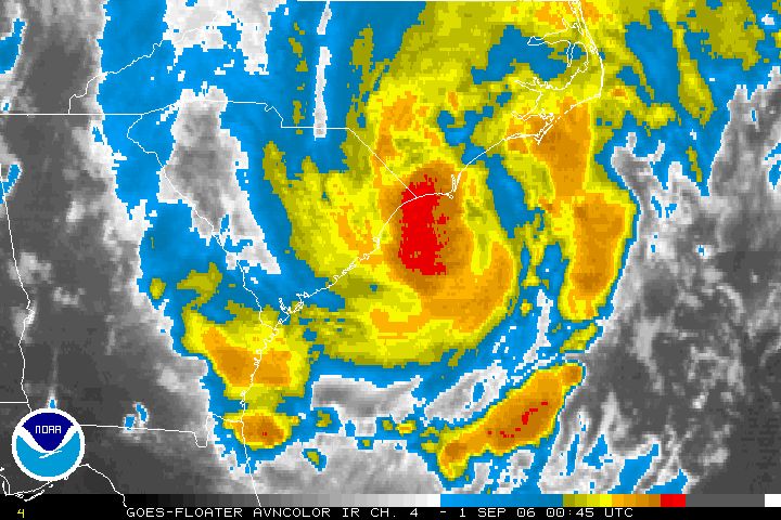
It is almost a Hurricane and it is very close to Wilmington, North Carolina tonight. Ernesto is packing a punch. It is a vigorous tropical storm producing heavy rain and tornadoes as it moves onshore. At 8pm area observations included Kitty Hawk at 81F with heavy rain and an east wind at 17 gusting to 28 mph. Pea Island on the Outer Banks was E at 33G39 and Frying Pan Shoals southeast of Cape Hatteras was SE 39G49 knots which is close to 60mph. Waves were 15 feet. Already Wilmington has received 6.2 inches of rain. The storm will move across the state overnight and into Virginia tomorrow.
Flooding expected in Northeast
Ernesto will move towards Ontario
Tropical Storm Ernesto moved back over the Atlantic waters early this morning after crossing Florida. The storm produced heavy rain but little else in the sunshine state. Tropical Storm Warnings are in effect from Georgia north toward the Outer Banks of North Carolina. In addition flood watches have been posted for all of the southeast & mid-Atlantic states and may be extended into New York and Pennsylvania.

A Special Weather Statement has been issued for Ontario. The tropical remains of Ernesto will move into Ontario near Lake Erie on Saturday. Heavy Rain from 40-60mm along with gusty winds will occur throughout the weekend. Heavy Rain Warnings may be needed.

KATRINA: I watched a show on Hurricane Katrina last night on the Discovery Channel. It was very well done. Even one year later, and after tracking storms for over 25 years, I have a problem in dealing with the enormity of the disaster. One thing that has not changed in the year is the stupidity of politician's. I don't like to get political, I stick with the weather, but bureaucracy is an amazing thing. Take one of the strongest storms ever to strike the planet, stir in lots of water and sprinkle with stupidity, you get the idea. No one knows for certain how many of the deaths were needless, we may never know. People waited for days while politicians congratulated each other on the "flawless evacuation plan" and the "great progress of the recovery." One year later many neighborhoods are still waiting for a plan, still waiting for the storm to pass.

One thing is for certain, there were and continue to be many heroes who made and continue to make a difference. Ordinary people doing extraordinary things along the Gulf Coast.

Tuesday, August 29, 2006

5pm Ernesto Update
Tropical Storm Ernesto has yet to intensify although the storm appears more organized on radar. The storm will move northeast across Florida into tomorrow before making a second landfall in the Carolinas.

Computer models bring the storm inland across the Appalachians and into southern Ontario this weekend. Our area will see heavy rain Saturday and Sunday. Stay tuned.... the threat for flooding across the Northeast and Ontario is very real.

The immediate future of the storm has it dumping heavy flooding rains across Florida. Up to 10 inches of rain may fall. The waves will be pounding the coast from Florida to The Outer Banks with some beach erosion.
Ernesto back over water
Tropical Storm Ernesto has emerged off the Cuban coast just south of Key West - Florida. The storm is expected to move northwesterly at about 12-14mph today and should begin to affect south Florida by mid-day. It will move across the central Keys and across the state towards Jacksonville before moving back over the Atlantic waters by tomorrow. At present a Tropical Storm Warning and Hurricane Watch are in effect from Bonita Beach and New Smyrna Beach south along both Florida Coasts. Ernesto may still become a Hurricane before landfall.

Once over the Atlantic after hitting Florida the center will make a second US Landfall near the North/South Carolina border, further west than initial runs. It is also expected to become a significant weather event for the eastern Great Lakes. Stay tuned to that for this upcoming weekend. Next update later this afternoon......

Monday, August 28, 2006

Ernesto over Cuba
Tropical Storm Ernesto the first storm to have reached hurricane status in the 2006 season has moved inland over Cuba tonight. The storm has been erratic and difficult to forecast. Early forecasts had the storm as a major hurricane affecting the Gulf Coast region. It now appears the storm may affect Florida as a tropical storm before moving up into the Carolina and Mid-Atlantic states. The storm reached hurricane status for a time late Saturday into Sunday morning. It will affect the US on the anniversary of Katrina. I am hoping and praying it stays away from Hatteras Island. I have vacationed there over the last 15 years and hope Avon and the surrounding villages are spared. It will be close call according to the computer models.

As of 8pm a Hurricane Watch and Tropical Storm Warning is in effect for the Florida east and southwest coasts. All interests in the southeast US should monitor the progress of the storm. The models are mixed with the storm affecting areas from Cuba to Maine a possibility. Updates can be found at hurricanecity.com.

I will keep a close eye on the system over the upcoming hours. Another update will be posted early tomorrow morning.

Friday, August 25, 2006


Debby lost in the Atlantic
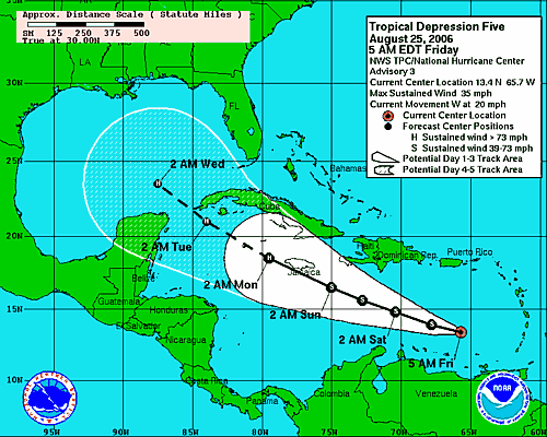
TD#5 to become Ernesto
Tropical storm Debby continues to meader across the open waters of the Atlantic about 1250 miles northwest of the Cape Verde Islands. At present the storm posses no threat to land. In the meantime Tropical Depression 5 continues to strengthen and should become Tropical Storm Ernesto today. This storm bears watching as it moves across the Caribbean south of Puerto Rico. The storm may not survive the next 72 hours, but if it does it will move into a more favorable environment in the Gulf of Mexico. Please visit Jim at HurricaneCity.com for updates.

Our weekend weather should be cool with showers Saturday. August continues to be a disappointment with very cool weather the last week or so. Summer is too short to give up three weekends in the month to "fall like" weather. Lets hope September is warmer. Despite the 11C (51F) start today and the cloud cover I am wearing shorts to work. Why? Because it is August......

Tuesday, August 22, 2006


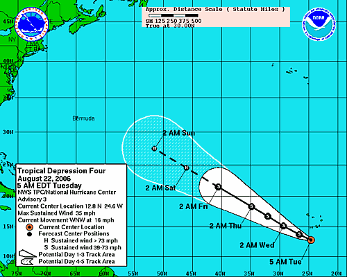
TD #4 forms in Eastern Atlantic

Tropical Depression number 4 has formed in the far Eastern Atlantic, 150 miles south of the Cape Verde Islands. The storm is in a very favorable area for development and should become Tropical Storm Debby by later today. It is forecast to continue to slowly strengthen as it moves westward. It is too early in the period to tell if it will affect the east coast of North America. However the Caribbean and Gulf Coasts are fine this system is too far north at this time.

Monday, August 21, 2006

Quiet Weather
Hey folks, sorry for the lack of input as of late, but it has been exceptionally quiet both in the tropics and in North Grenville. Yesterday was breezy and cool, almost fall like in Eastern Ontario and west Quebec. About 10-12mm of drizzle and showers fell with cool temps of around 17-20C. It was a far cry from Saturday's reading of 30C plus with humidex values in the 34 range. August has been fairly quiet from a thunderstorm point since the outbreak at the beginning of the month. This week will be cool in Kemptville and Montreal with on and off showers Tuesday and again Thursday.

• Hurricane forecasters are watching a disturbed area of thunderstorms south of the Cape Verde Islands for possible development.

• A severe weather outbreakoccurredd yesterday in the high plains from Colorado up to Manitoba. Here is some neat video of the storms. Hail and a tornado were reported also in southern Manitoba.

The shot below was taken at the 49th Annual Stowe Car Show last week. It was an awesome weekend.....can't wait till the 50th!

Friday, August 11, 2006

Awesome weekend in the east
Well the weather has finally calmed a little in Ontario. This weekend will be excellent from Toronto to Montreal and Ottawa. Very low humidity, cool nights and warm seasonable days. This weather will extend into New York and New England.

• Heavy thunderstorms with hail are occurring in Saskatchewan and Alberta, warnings are out for those areas. The most convection is occuring north of the Trans Canada this morning, however most of the south can expect a round of storms before much cooler air moves in on Saturday.

• Environment Canada confirmed that 8 tornadoes occurred in the province last Wednesday, August 2 including two F-2 storms. It was the worst outbreak since the Barrie twisters in 1985. No deaths were reported but power was out to over 150,00 and damage is in the millions. So far this season 17 tornadoes have occurred, 3 more than all of last season in the province.

Friday, August 04, 2006

What a week!

I must confess I don't know where to start. It has been quite a busy week in the weather department across North America. Fierce thunderstorms, scorching heat and a tropical storm for good measure.

Well I will start with the home front. Kemptville hit 38C on Monday. That was the warmest I have ever recorded on my thermometer. It was just shy of the official high of 36C in Ottawa 30 minutes north of us. Add the humidity and the humidex was off the charts close to 50C in places. Sweating was not an option.

The heatwave, at least in Kemptville, came to an end late Wednesday with a line of thunderstorms that was far worse in other locations. We had gusty winds and some rain. Lanark County to our west was under a tornado warning. An F-1 tornado touched down in the small village of Combermere south of Barry's Bay with extensive damage.

The previous night storms pounded Montreal leaving more than 500,000 people without power and killing 2. One motorist was killed when a tree fell on his car in the Cote Des Neiges district. Many are still in the dark. Though it is cooler, it is still near 30C, without a/c this can prove uncomfortable. Hydro Quebec estimates the power to return over the weekend. Over 400 crews, some called back from vacation, have been working on the downed power lines and poles. Over 100mm of rain fell in Montreal during Tuesday and Wednesdays storms. 150,000 have no power in Ontario.

Tropical Strom Chris has now been downgraded to a depression and is meandering through the Caribbean Sea heading for the Bahamas. It may regain tropical storm strength as it heads into the Gulf Of Mexico.

Elsewhere the east coast of the US has been under extreme heat alerts as incredible heat and humidity dominate. New York's La Guardia Airport was over 100F three days in a row with overnight lows only in the 80's. Utilities in both New York and Ontario were advising people to conserve, fearing brown outs. Gov Pataki even opened state parks for free so people could cool off by the water. The heat is blamed for hundreds of deaths.
Monday, July 31, 2006

Heatwave heads north and east

The heatwave that has held the US in most of its grip for the last month will spread northeast into New York, New England, Ontario and Quebec. Excessive Heat Warnings are in effect along the east coast from New York south. High Heat and Humidity Warnings are in effect for most Metro areas in eastern Ontario and Quebec.

Expect hihgs on Tuesday and Wednesday to be between 33C and 37C or very close to 100F in Toronto, Ottawa, Montreal, Watertown, Rochester, Syracuse and Ogdensburg. Factor in the humidity and it will fell like 42-45C.

Drink plenty of water and avoid heavy outdoor activity tomorrow and Wednesday. Some relief will move in to northern areas late Wednesday and Thursday.

Wednesday, July 26, 2006


Very warm and muggy today we are currently at 29C in Kemptville but the humidex feels like 37C.

Yesterday's rain totals from 4 different thunderstorms:
Morrisburg 67mm
Kemptville 60mm
Ottawa 32mm
Winchester 23.8mm

Below is a scene repeated across some areas of Eastern Ontario as Hydro 1 crews work on lines.

Tuesday, July 25, 2006


Storms, storms and more storms
The "bubble" that has been protecting Kemptville from any big thunderstorms this summer let go last night. It took a very week cold front moving into marginally warm air that would trigger our first round of storms around 3:00 am. The storms produced spectacular lightning and about 2-3mm of rain. Sporatic power outages occured.

This would set the stage for more severe weather today. At least three separate lines of storms crossed the Rideau Valley heading south. In all over 50mm of rain fell this afternoon in both my rain gauges. There was ponding of water in many areas but no damage was reported. Lights flickered all afternoon and power was disrupted in some areas.

More storms are expected on Thursday across Eastern Ontario in the warm and humid air as highs approach 30C.

Friday, July 21, 2006


Tropical Storm Beryl
heads for Nova Scotia

• The northern edge of Beryl is beginning to affect the southern coast of Nova Scotia as well as New Brunswick. Forecasters are expecting the storm to dump over 50mm of rain in the area along with gusty winds. This is the second named storm of the young Atlantic Hurricane season, we had 5 at this time last season. The storm will rapidly lose its tropical nature as it moves northeast into the Atlantic Ocean.

Beryl brushed across Eastern Massachusettses with rain and wind but nothing more than that last night.

• It was hot this week in Kemptville. I recorded a max temperatures of 36C on Monday. The official reading was 33C at the MNR building.

• Hydro workers in Ontario continue to restore power to the more than 100,000 customers that lost it from Lake Superior to the Quebec border on Monday. The thunderstorms lashed the area with 100km/h plus winds and heavy rain. Two tornadoes were reported in New Market and numerous trees, some as old as 100 years, were flattened on Manitoulin Island. One death was reported from Monday's storms in Ontario.

• Glasgow, Montana did not reach 90F on Wednesday marking the first day since July 4 that it failed to do that. It was the 5th longest stretch of 90 degree plus weather since records began. The area along with most of western Canada and the Pacific Northwest will remain under intense heat again this week with temperatures approaching 100F (37C) in many areas.

• The Kemptville "bubble" remained in place last night. While many areas continue to see thunderstorms, parts of the Highway 43 corridor from Merrickville to Kemptville continue to miss out. The storms part as they approach the area going north into Ottawa or south into New York State.

Monday, July 17, 2006

High heat - smog and humidity
The weather in the east has become extremely hot and humid. A smog warning is in effect for most of southern Ontario. Very poor air quality has also resulted in an Air Stagnation Advisory for the northern counties of New York State. A High Heat and Humidity Warning has been posted for southwest Quebec.
As of 4pm, Kemptville had reached 32C with a Humidex value in the dangerous range at 42C. Brockville had a reading of 43C to be the highest in the province. Montreal was at 32C. A Severe Thunderstorm Watch is now in effect for most of eastern Ontario. Heavy Thunderstorms are possible in the tropical air through tonight as a cold front presses east.

Monday, July 10, 2006


Viva l'Italia
...siamo fieri di voi senso andare l'Italia

Friday, July 07, 2006


Hot weather returns
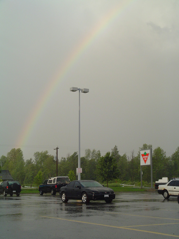
Big changes in the east are expected over the next several days as very warm humid air streaks into Ontario and Quebec. Temperatures will be from 27-30C right into next weekend. A few thunderstorms are expected as well. It has been a wild stretch of weather lately. Severe thunderstorms in Ontario this week caused flooding and toppled some trees. The Kemptville area was spared for the most part with the exception of a strong storm late Tuesday that brushed the area. The winds were strong enough to tear branches from some trees and the parting storm left a rainbow behind(above).

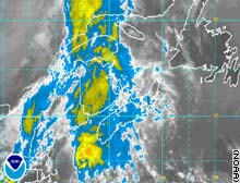
In addition to the storms in Ontario, two confirmed F-1 tornadoes were reported in New Brunswick. Today smoke from the forest fires in the northern Prairies and Rockies is drifting east into the eastern part of the country. Satellite images show the smoke stretching up and down the eastern coast.

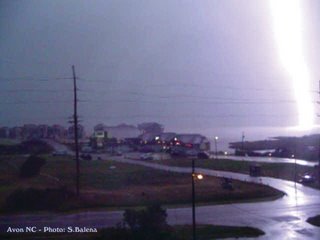
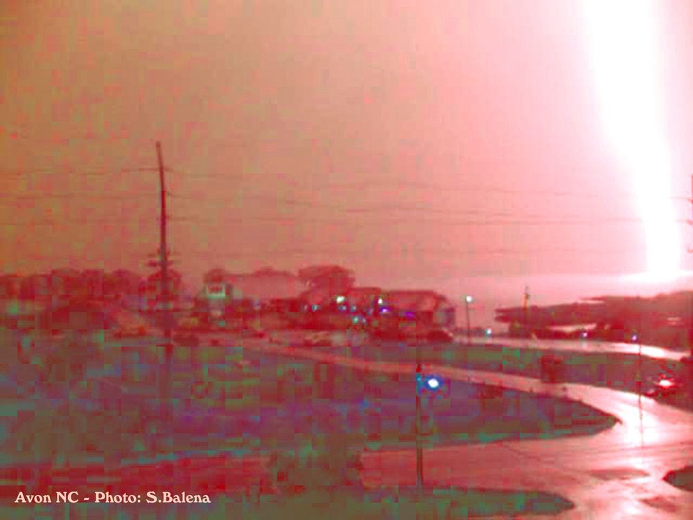
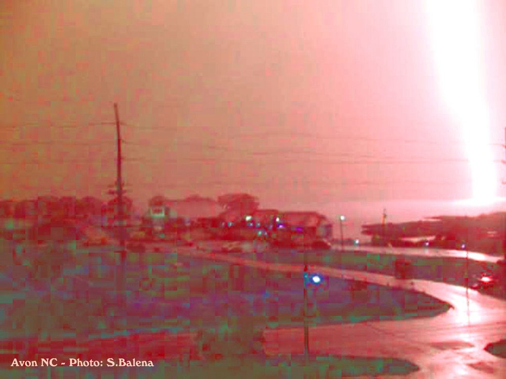
The photo below is one I took on Friday, May 26, 2006 on the Outer Banks of North Carolina. It is a lightning strike illuminating Pamlico Sound near Avon, North Carolina.


Thursday, June 29, 2006

Severe Weather likely today in Kemptville

This has just been issued by Environment Canada......
SEVERE THUNDERSTORM WATCH ISSUED For Kemptville BY ENVIRONMENT CANADA BULLETIN ISSUED AT: 10:55 AM EDT THURSDAY 29 JUNE 2006 CONDITIONS ARE FAVOURABLE FOR SEVERE THUNDERSTORMS TO DEVELOP. THIS IS AN ALERT TO THE POTENTIAL DEVELOPMENT OF SEVERE THUNDERSTORMS WITH LARGE HAIL AND DAMAGING WINDS. MONITOR WEATHER CONDITIONS..LISTEN FOR UPDATED STATEMENTS. IF THREATENING WEATHER APPROACHES TAKE IMMEDIATE SAFETY PRECAUTIONS.

Wednesday, June 28, 2006

Death toll at 9 in east coast floods
Two more deaths were added to the growing total from severe flooding from the Carolinas to Ontario. The latest flood deaths were along a stretch of I-88 near Binghampton, NY. Yesterdays rains amounted to several more inches in the water logged northeast. In Kemptville 25mm fell, most of that in an afternoon deluge. Over 65mm fell in the Gatineau Hills and across the Laurentians.

More thunderstorms are developing this afternoon with the threat of more heavy rain a reality.
Flood warnings and watches remain in effect for portions of New England the Northeast and Mid-Atlantic.

Tuesday, June 27, 2006


Tropical Rains continue along Atlantic Seaboard...

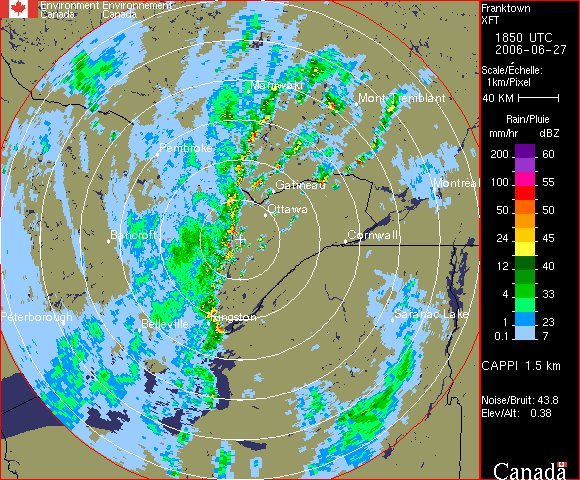
The heavy tropical rains that have inundated the US East Coast are now spreading into Ontario and Quebec. Heavy rain with embedded thunderstorms are lining up across eastern Ontario at this hour. The area can expect up to 50mm of rain this afternoon and tonight.

More is on the way.....the rain has flood watches and warning stretching from southern Quebec into Georgia. The DC area was hit hard yesterday with close to a foot of rain. Roads were washed away, trees toppled and basements flooded. The National Weather Service will be investigating low pressure southeast of the Outer Banks that could become a tropical depression at anytime. it will continue the endless southeast flow of warm and moist air into the Appalachians and eastern Canada.