 |
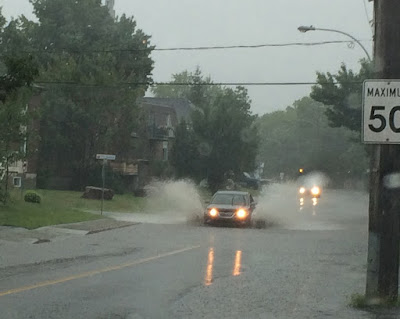
| Rapidly developing thunderstorms produced torrential rain and flooding on L'Ile Perrot, Saturday, July 23. (ValleyWX) |
Hot and humid weather took a one-day break on Sunday after Saturday's wicked weather. Strong thunderstorms rapidly developed on Saturday afternoon north of Montreal, and moved southeast across southern Quebec and into upstate New York and Vermont. The storms produced 25mm (1 inch) of rain here on L'Ile Perrot in under one hour. The result was flooding on numerous roads. Such was the case as well across other parts of Montreal. Some roads, especially ramps and viaducts on and off Highway 40, had to be closed until the water receded. The same cluster of storms dropped hail up to 2cm and produced winds in excess of 100km/h across Valleyfield and Vaudreuil and south of the city into the Townships. Tornado warnings were even issued southeast of Montreal, with several of the storms showing signs of rotation. Numerous trees and power lines were knocked down. South of the border, strong winds left several boaters requiring rescue on Lake Champlain. The wind also knocked out power to thousands in Vermont, some still in the dark this morning. One fatality was reported in Vermont.
 |
| Searing heat and humidity across a wide portion of Canada this July has resulted in numerous rounds of severe thunderstorms. The photo above is from my good friend in Moose Jaw, Saskatchewan (Dayna Smith-Short) |
This morning, the heat and humidity are building once again, as a warm front approaches from Ontario. Showers and isolated thunder will give way to partly sunny and muggy weather through mid-afternoon. Temperatures will rise rapidly to around 30C (86F). A cold front will cross the area late in the day, with another round of robust thunderstorms. Some of the storms, like Saturday, may have heavy rain and small hail. Skies should clear after midnight, with a warm and dry Tuesday expected. The low tonight will be around 20C (68F), with the high Tuesday near 27C (81F).


No comments:
Post a Comment