As Canadians we talk about the weather relentlessly, I just talk about it a little more! I hope to provide useful information to my family, friends and all those who simply enjoy talking about the weather. My primary region of concern is the St. Lawrence Valley of Quebec, Ontario, and New York, as well as our neighbouring regions. This Blog is dedicated to my late father for inspiring my interest in weather, and to my "all weather" pup Bella.
Monday, December 04, 2017
Major pattern change on the way for eastern Canada
Environment Canada has issued a wind warning for the Richelieu Valley for late tonight and early Tuesday. Expect south winds gusting up to 90km/h.
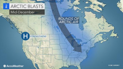
The mild weather is about to come to an end, and won't likely return until May. No, but seriously, Arctic air is set to invade the Great Lakes over the next 48 hours, sliding into eastern Canada by the weekend. The catalyst will be a major winter storm developing over Colorado, and moving northward toward Lake Superior. Montreal, southern Ontario and Quebec will be on the warm side of the system, with a surge of mild air through Wednesday. Closer to the center of the storm, heavy rain is forecast from Michigan into central Ontario. West of the storm track, blizzard conditions are expected from the Dakotas into extreme southeast Manitoba and northwest Ontario. Forecasters are calling for 30 to 40cm of wind driven snow in some regions, along with dropping temperatures. Travel is not advised tonight and Tuesday across portions of the Dakotas, Minnesota and northwest Ontario.
In Montreal, sunshine on Monday will fade away as clouds increase. Tuesday will be cloudy and very mild, with high temperatures soaring to 9C (48F). Winds will increase tonight, becoming quite strong in the afternoon, gusting up to 60km/h. A cold front, the leading edge of the arctic air, will sweep across the area on Tuesday night into Wednesday, with gusty winds, rain and dropping temperatures. The balance of the week will be much colder, with the chance of flurries through Saturday. Temperatures are forecast to become increasingly colder as we head into the weekend. Daytime highs will struggle to reach 0C (32F) by Friday. At this time, it looks like the balance of the month will remain below freezing in southern Quebec, with frequent chances for accumulating snow. Next week, daytime high temperatures will be no better than -3C (27F). The details will become clearer as time moves along, but expect much colder weather starting late this week.
Subscribe to:
Post Comments (Atom)

No comments:
Post a Comment