 |
| Lac St-Louis lapping at the shoreline of L'Ile Perrot early Monday morning. Minor flooding is occurring around the lake, as water levels continue to slowly rise. (ValleyWeather Photo) |
Above-normal precipitation, along with seasonal snow melt, has prompted authorities to issue a flood watch for southern Quebec, including metro Montreal. According to Quebec water watchdog Hydro Meteo, several rivers have or will exceed flood stage this week. They include, but are not limited to, the Ottawa, St. Lawrence, Mille Iles and Riviere des Prairies around Montreal and Laval. The Richelieu River, southeast of Montreal, is also on the rise, as is Lake Champlain, which is expected to approach 100 feet this week. The normal level for the lake is either side of 95 feet. North of Montreal, flooding has already occurred in Rawdon, along the Ouareau River. In Mirabel, 22 homes have been evacuated.
 |
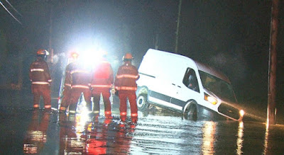
| Moderate flooding is occurring north of Montreal in Rawdon, Val Morin, Val David and Mirabel, shown above. (CBC Photo) |
Minor flooding is anticipated along river roads in and around the entire region. Rivers and lakes are swollen, and in some cases, with rapid and erratic water levels and flows. Caution is advised near any body of water. Precipitation amounts in southern Quebec over the last two months have been well above normal values. In March, Montreal measured 114.6mm of precipitation at Trudeau Airport. The 30-year average is 69.1mm. To date in April, over 114mm of precipitation has fallen, with only half the month gone. April usually records 82.2mm for the entire month. A break in the rain is expected on Tuesday, before another series of storms arrives for Wednesday through Friday. Low pressure is forecast to approach New England Wednesday, spreading rain into southern Quebec. Another 25mm is expected. Additional flooding is likely.


No comments:
Post a Comment