Monday, January 10, 2022

Frigid cold for the next 36 hours in Montreal

Winter has been relatively tame to date in Montreal, with mainly mild weather and very little snow. That will make the next 48 hours seem even colder for most, as frigid arctic air settles over the province. Morning lows early Tuesday will be in the middle minus 20s, with windchill values approaching -40C in many locations.

Extreme cold warning for southern Quebec for Monday night and Tuesday. Expect temperatures in the -20s with windchill values approaching -40C. Exposed skin can freeze in minutes. Make sure your pets are indoors.

Arctic air will invade southern Quebec on Monday behind weak low pressure that brought Montreal a few centimetres of mixed precipitation on Sunday. The temperature briefly warmed above freezing late Sunday afternoon, but has since dropped considerably on gusty northwest winds. Trudeau Airport early Monday morning was -12C (10F), and I don't expect any movement on the mercury today, perhaps even dropping a few degrees by sunset.

Tonight, the coldest airmass of the season will settle over most of Quebec, with extreme cold warnings in effect across the province. The forecast low for metro Montreal is -26C (-15F), which if reached, would make it the coldest night in Montreal since January 14, 2018. To date the coldest low was -21C (-6F) on January 3. The coldest day last winter was -23C (-9.5F) on January 31.

Accompanying the cold will be a brisk northwest wind between 20 and 40km/h, producing windchill values close to -40C for many parts of the province. The temperature will slowly recover on Tuesday under partial sunshine, reaching -19C (-2F) by late in the day.

Much milder air arrives by Wednesday, with daytime highs reaching -5C (23F), along with just a few flurries. Colder air returns by the end of the week, but not as frigid as the next day or so. At this time, there are no major storms on the horizon. However, if your travels take you into southern Ontario or western New York, expect areas of snow squalls, with very heavy snow and near-blizzard conditions. This is especially true south of Watertown, New York, along Highway 401 near Kingston and southeast of Georgian Bay.

Thursday, January 06, 2022

Brief arctic blast as major storms avoid Montreal

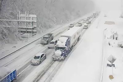
A Virginia Department of Transport traffic camera showing stranded motorists on a section of Interstate 95 south of Washington D.C. in Fredericksburg, Virginia on Monday, January 3. Some drivers were trapped in their vehicles for up to 27 hours. It was the largest storm is several years in the region. (VDOT Photo via Twitter)

In an all too familiar pattern, the worst of the winter weather continues to avoid the Montreal region. If you do not like snow, then that news is good. So far this season, Montreal has only measured  46.2cm of snow for the entire season at Trudeau Airport, with no major storms to speak of. Slightly more has fallen in the suburbs to the south and west. While we are missing the storms, large portions of both Canada and the US are not. This includes the British Columbia south coast that has had several major snowstorms already this winter. 

The first big snowstorm of the season moved across the middle Atlantic states this week, with up to 30cm of snow on Monday in places like Virginia and Maryland. The storm snarled traffic along the major north to south Interstate 95 corridor, stranding hundreds of motorists for up to 24 hours south of Washington D.C. in northern Virginia. A new storm is taking aim at southern New York and New England for Friday, with 20cm of snow forecast for Boston.

Lake effect snow hammering the New York State Thruway south of Buffalo on Thursday, January 6.

That same storm will deepen rapidly over the Atlantic, with blizzard conditions expected as 80km/h winds combine with up to 40cm of snow through parts of Atlantic Canada on Friday and Saturday. That storm will just brush southern Quebec, with clouds and perhaps a few flurries on Friday. Only a couple of centimetres of fresh snow are likely in southern Quebec between Thursday and Sunday.

On Thursday, a strong cold front moved across the Great Lakes turning on the lake effect snow machine. Waves of lake effect snow are expected southeast of Georgian Bay in Ontario as well as in the Buffalo and Watertown, New York metro regions from Lakes Erie and Ontario.

The next storm will also miss Montreal as well, dropping heavy snow across the Ohio Valley, southern New England and Atlantic Canada. (AccuWeather)

Arctic Blast

This weekend mild air will briefly invade southern Quebec, with a few flurries or spotty showers expected early Sunday. The temperature will rise close to the freezing point late Saturday and early Sunday in Montreal. Late in the day, an arctic cold front will introduce the coldest air of the season to southern Quebec, with lows dropping to -10C (14F) by Monday morning and continuing to drop all the way down to -26C (-15F) by Tuesday morning in the city. Highs will remain in the -20s on Tuesday along with frigid windchills. Some locations in southern Quebec may touch -30C (-22F) by Tuesday morning. The temperature will begin to slowly warm by Wednesday.

Friday, December 31, 2021

Messy winter storm for Ontario and Quebec to start 2022

Mixed precipitation will change to all snow late New Years Day, as a winter storm moves from the southern plains into New England. Expect 10 to 15cm of fresh snow in Montreal by noon Sunday. Much colder weather will follow the snow for Sunday and Monday. Temperatures will moderate by Tuesday.

Happy New Year!

It has been quite the year. It comes to an end Friday night, with just a few flurries and spotty freezing drizzle across southern Quebec. Temperatures will be very mild, within a degree or two of the freezing point.

On Saturday, a warm front will lift across the region, followed by a potent cold front late in the day. Along both fronts, spotty precipitation is expected, in the form of light rain or freezing rain. Low pressure is forecast to pass south of our region across New England into early Sunday, pushing deeper moisture into southern Quebec.

Mixed precipitation is expected to develop late in the afternoon, changing to all snow by 7pm or so in the Montreal region and across eastern Ontario. The heaviest snow will fall along the St. Lawrence Valley, towards the US border, with a good 10-15cm expected. Winds will become rather gusty out of the west up to 40km/h, and the temperature will fall from daytime highs of 3C (38F), down to -7C (19F) by Sunday morning. 

Winter weather advisories have been issued for eastern Ontario and all of northern New York and Vermont. They may be extended into southern Quebec on Saturday.

Travel will become difficult Saturday night, with rapidly accumulating snow and falling temperatures. Sunday will be breezy and cold, with dropping temperatures and scattered flurries. Monday morning will be the coldest morning of the season so far, with morning lows down to -18C (0F).

Stay safe and healthy and thank you kindly for reading as I say goodbye to my 42nd year writing and talking about the weather. 

Thursday, December 30, 2021

Freezing rain to start the New Year in Montreal

Tuesday was a perfect day for a holiday stroll along the waterfront in Verdun. Temperatures were relatively mild for late December at -3C, along with very light snow falling. (ValleyWeather Photo)

A special weather statement has been posted for southern Quebec for a messy mix of snow, freezing rain and rain on Saturday. The storm will be followed by windy, frigid weather on Sunday.

We can expect a stormy start to the New Year in Montreal, as a messy weather system heads our way. The weather has been rather mundane this holiday season, with moderate temperatures and fairly light precipitation. The real weather story has been across western Canada, where an arctic outbreak has resulted in temperatures in the minus 30s and 40s, with windchill values in the minus 50s at times. The intense cold has pushed snow onto Vancouver Island and south into Seattle and Portland. Dozens of record-low temperatures have been established, including -42.1C at Edmonton, with a windchill of -55C.

Some of that cold will make into southern Quebec by late Sunday, but before then, we have another sloppy winter storm. Low pressure is expected to move from the southern plains into the Great Lakes, passing near Montreal Saturday night. Precipitation is expected to begin Saturday morning, with perhaps a few hours of freezing rain. The temperature is expected to eventually rise above freezing to 3C (38C) in Montreal by the afternoon New Years Day, with rain being the main precipitation. Snow and freezing rain will persist north of the city. An arctic boundary will move across the region late Saturday into the overnight hours, accompanied by a surge of cold air. Any precipitation will change back to snow and end on Sunday.

The temperature will drop all day Sunday in Montreal, down to -20C (-4F) by Monday morning. Monday will be fair but breezy and cold, with a high of -12C (10F).

The various computer models are having a difficult time nailing down the exact track of the storm. That will have a tremendous impact on the quantity and type of precipitation for Montreal. At this time, we can expect 15-20mm of mixed precipitation, falling in various forms. I will provide an update with more specific details and any weather warnings that might be issued as the forecast develops.

In the meantime, expect fairly docile weather today and New Years Eve, with just some light snow or freezing drizzle. Travel conditions will deteriorate in Saturday as the day progresses.

Friday, December 24, 2021

Messy Christmas Day forecast for Montreal

A spectacular sunrise along the St. Lawrence River in Pointe-Claire, taken on the shortest day of the year. Winter arrived at 10:58 am on Tuesday, December 21. Daylight will slowly begin increasing as the days get longer.

Winter weather advisories are in effect across eastern Ontario, northern New York and Vermont for a period of freezing rain and snow on Christmas Day. No weather warnings are in place for southern Quebec at this time, but the same weather can be expected here, with a light wintry mix of precipitation. Travel with great care on Saturday.

The coldest air of the season has been over southern Quebec for the last 48 hours. Thursdays high of -9.4C (15F) was the coldest since last winter. Early Friday morning, the temperature dropped to -16C (3F) here on Ile Perrot, and combined with the light breeze, it felt as cold as the -20s while walking the dog. But I must admit, the weather seems just perfect for me for December 24.

Friday will be partly cloudy and cold, with daytime highs remaining around -10C (14F). The weather turns rather messy on Christmas Eve and Christmas Day across Ontario and Quebec. Low pressure, not a particularly strong storm, will slide across the lower Great Lakes into New York and eventually off the east coast. A warm front will lift north into New York State. Along and well to the north of the front, here in southern Quebec, precipitation will fall in the form of light snow and freezing rain.

I expect precipitation to begin late Christmas Eve in eastern Ontario and move into southwestern Quebec overnight. A centimetre or two of snow is possible before changing to freezing rain from Montreal south and west. The cold air will be difficult to scour out of the St. Lawrence Valley so despite warning temperatures aloft, ground temperatures will remain well-below freezing in Montreal. As a result, we can expect a few hours of light freezing rain across the region. North and east of Montreal, any precipitation will remain in the form of snow. Any mixed precipitation will taper off to flurries by late Christmas night.

The mix of precipitation and colder temperatures in the minus 5C to -7C range, along with gusty northeast winds, will make travel slick and highly changeable on area highways. Travel with great care Christmas Day. As we have already witnessed this winter, it does not take much frozen precipitation to create treacherous driving conditions.

Precipitation will end by early Sunday, with lingering clouds and a high of -2C (29F) forecast for Montreal.

Saturday, December 18, 2021

Winter returns to southern Quebec on Saturday

Our relatively mild December will come to an end on Saturday as winter returns to Montreal. A storm system will deliver 5 to 10cm of snow, followed by cold air through Christmas.

A light to moderate snowfall is forecast for southern Quebec on Saturday, just 48 hours after record warmth. Low pressure will move from the Ohio Valley across southern New England on Saturday spreading an area of snowfall north of the center. The snow should arrive in Montreal by 2pm and become steady into the evening hours. Precipitation will taper off after midnight.

Total accumulations of 5 to 8cm are possible from Laval into Montreal, with 5 to 10cm from Montreal to the US border. Across New England and northern New York, 15 to 25cm are possible. In eastern Ontario, along the St. Lawrence River, 5 to 15cm are forecast. In the Ottawa Valley, further from the storm center, les than 5cm is forecast.

Low pressure will move from Ohio across New England on Saturday delivering snow to southern Quebec. (AccuWeather.com)

Winter weather travel advisories are in effect for both sides of the St. Lawrence Valley in Ontario and New York, with winter storm warnings across parts of New York and New England. No warnings have been issued at this time for southern Quebec. Roads will become snow covered and slippery in Montreal this afternoon, so adjust your speed.

This will be an all snow event, unlike previous systems, as cold air is in place and will remain there right through the upcoming week. If snow for the holidays makes you happy, then you are in luck. What falls should remain for the foreseeable future guaranteeing a white Christmas for Montreal.

The high on Saturday will be -3C (27F) in Montreal, but it will feel colder with a northeast wind up to 40km/h. Temperatures will drop to -6C (21F) by Sunday morning, with some partial clearing. Sunday will be partly cloudy and cool, with highs remaining steady near -5C (23F). Skies will clear out Sunday night, with cold overnight lows near -12C (14F). There is a chance for more light snow Monday night.

Record Warmth

On Thursday, Montreal reached a very warm record-breaking 15.5C (60F), smashing the previous benchmark of 10.2C (50F) set in 1992. It was one of 8 new records set in the province. The day ended with another windy cold front, producing gusts up to 85km/h (52.8 mph) at Trudeau Airport. While there were scattered power outages reported by Hydro-Quebec, we managed to avoid the widespread damage experienced last Saturday night.

Wednesday, December 15, 2021

One more warm windy storm - then winter returns

Over 700 lineman helped to repair the damage from Saturday nights windstorm across Quebec. Another wind event is in our future, with 70 to 90km/h gusts possible late Thursday evening in Montreal. (Hydro-Québec Photo)

Freezing rain, record warmth and then strong winds expected across southern Quebec and Ontario Wednesday and Thursday.

We are awaiting yet another warm and windy winter storm. Low pressure over the central US will cross the Great Lakes and move into Quebec on Thursday. A very pronounced warm front will cross southern Quebec late Wednesday followed by a surge of record-breaking warm air.

Along and ahead of the front, portions of eastern Ontario and southern Quebec may experience a few hours of light mixed precipitation. Being overly cautious at this time, Environment Canada has posted freezing rain warnings for parts of southern Quebec, excluding the island of Montreal for now. The frozen precipitation will be very light and will not last long at any one location, however any ice can make driving very dangerous. The best chance for freezing rain will be between 3 and 7pm Wednesday before temperatures rise.

On Thursday expect a partly cloudy, windy and very warm day, with a record-breaking high of 13C (55F) forecast for Montreal. The record to beat is 10.2C (50F) set in 1992. This will be our second record high this week as Montreal reached 11.5C last Saturday during the windstorm.

Over 700 lineman from Hydro-Quebec, with help from their New Brunswick Power colleagues, brought over 400,000 customers back online over the last few days. As of Thursday morning there were still 693 customers scattered throughout the province without power. Unfortunately another potent cold front is on the way with strong winds expected.

More Strong Winds for Montreal

Winds will begin to ramp up on Thursday, as a strong cold front slides east across Quebec. In advance of the front, strong southwest winds will develop, gusting up to 90km/h at times into the evening hours in Montreal. While the winds will not be as strong as Saturday or last as long, they will be close to warning criteria once again.

Behind this storm, winter returns to Montreal. Much colder air will settle into the province on Saturday, along with a few centimetres of snow. The ground will remain white through Christmas Day in Montreal, with continuous below freezing temperatures forecast and another few opportunities for light snow.

Sunday, December 12, 2021

Fierce winds leave nearly 400,000 Quebecers in the dark

Laval firefighters responded to call after call for downed trees, power lines and destroyed tempos Saturday evening. The same was true across the island of Montreal. (Association des Pompiers de Laval Photo)

A powerful wind storm swept across southern Quebec Saturday evening, associated with strong low pressure lifting across the Great Lakes. Strong winds arrived shortly after 7pm in metro Montreal, sustained at 70km/h gusting to well over 100km/h for several hours.  A peak gust to 105km/h (65mph) was observed at Trudeau Airport at 8:45pm Saturday. The wind wreaked havoc across southern Quebec, damaging trees and power lines and destroying many temporary winter garages (tempos) in the process. There are reports of roof damage as well.

Firefighters and first responders across southern Quebec were kept busy, with hundreds of calls for service. Hydro-Quebec reported nearly 400,000 customers without power at the height of the storm. That number has since fallen to 331,000 as of 9am Sunday morning. The utility has over 400 men and women on the ground and will work around the clock to restore service.

Another destroyed tempo sits outside a school in Chomedey-Laval Sunday morning. (Photo: T. Giotsalitis)

Winds have also eased somewhat Sunday, but the day will be blustery, with west winds up to 60km/h persisting during the daylight hours.

The same system also cut power to hundreds of thousands of homes from Michigan across Ontario and into New England. A peak wind gust in Ontario of 130km/h (8o mph) was recorded at Point Petre on the northeast shore of Lake Ontario.

The storm was the same one that produced the devastating and historic tornado outbreak across the mid-south US. Dozens of tornadoes took over one hundred lives and levelled numerous communities.

Saturday, December 11, 2021

Power out to over 375,000 in Quebec after 100km/h winds

The temperature is slowly warming up this morning in Montreal, but surfaces remain very icy. By late this afternoon and this evening, a powerful cold front will bring with it 70 to 100km/h winds in the St. Lawrence Valley. Wind warnings are in effect across southern Ontario and Quebec.

Sunday Update 6:45AM: The fierce winds of Saturday evening are slowly diminishing Sunday morning, and all weather warnings have expired for Montreal. The airport recorded a peak wind gust of 105km/h last evening. Hydro-Quebec is reporting over 375,000 customers without power in the province. I will update the numbers on last nights storm shortly. Stay safe...SB

Previous Post: High wind warning in effect for southern Quebec. Expect gust to 100km/h this evening in Montreal. The core of the strongest winds should arrive in Montreal around 7PM.

Freezing rain warning for the next few hours for 5-10mm of frozen precipitation.

A strong winter storm located over the lower Great Lakes early Saturday morning will move northeast into western Quebec today. A warm front is currently crossing the St. Lawrence Valley accompanied by an area of freezing rain. Freezing rain has been falling for a couple of hours in Montreal, with 5mm expected. Outdoor surfaces are very icy, but temperatures should warm above freezing in the next couple of hours allowing some melting to occur.

The balance of the day will feature well-above freezing temperatures, up to 10C (50F), with showers and periods of heavier rainfall at times. By this evening, a very strong cold front will cross the island of Montreal. Winds are forecast to turn to the southwest and gust up to 100km/h (60 mph). Winds this strong are capable of damage to loose structures, power lines and trees. Secure any outdoor objects including removing inflatable Christmas decorations. Winds will ease overnight but remain gusty into Sunday.

Deadly, rare December tornadoes have taken several lives overnight in the southeastern and south central US. (CNN)

This storm is very strong, with very deep central pressure. While we are not anticipating any thunderstorm activity in our region, there was plenty of severe weather Friday night. A very rare nocturnal December tornado outbreak has killed dozens in the southern US. Numerous tornadoes were reported overnight, including one that was on the ground for over 330KM. That storm crossed 4 states. First responders are sifting through widespread debris Saturday morning, and sadly the death toll will climb. There are numerous structures destroyed.

Just one of dozens of deadly tornadoes that swept across the Mississippi Valley overnight. 
This one was on the ground near Hayti, Missouri. Posted via Twitter @LiveStormsMedia (Brett Adair @AlaStormTracker).

This is all part of the same weather system impacting Quebec, a very strong midlatitude storm with very warm, moist air for this time of year. This story will be updated later today. Stay safe.

Friday, December 10, 2021

Another warm, wet and windy storm on the way for Montreal

Crews remove standing water in Saint Laurent after last Mondays storm. Make sure your rain gutters and sewers are clear as another 25mm of precipitation is on the way for Montreal over the next 24 hours. Freezing rain overnight will change to rain on Saturday as temperatures soar to over 10C (50F). (ValleyWeather Photo)

Freezing rain warnings have been issued north of Montreal and may be extended into the city for the overnight period Friday night. Keep this in mind f your travels take you out and about. High wind warnings are in effect on the US side of the border and these may also be requires across parts of eastern Ontario and southern Quebec late Saturday.

There is no change to our current weather pattern, as yet another warm and windy winter storm is on our doorstep. After a couple of days of light snow showers and cooler temperatures across southern Quebec, we are in for another big warm-up on Saturday.

After morning flurries Friday, skies will clear by afternoon, with a daytime high close to the freezing point. Clouds will rapidly fill in once again this evening in advance of a warm front. Strong low pressure will lift form the central plains, across the Great Lakes and into western Quebec Saturday, following a similar path to last Mondays storm. Montreal once again will be on the warm side of the system, with a mix of precipitation changing over to rain and then back to a few flurries late Saturday.

Precipitation will begin in the wee hours Saturday morning, likely starting as a period of freezing rain in Montreal, with temperatures hovering just below the freezing point in the St. Lawrence Valley.

On Saturday, strong south winds will push temperatures up to 10C (50F), with all precipitation changing to rain. The rain may be heavy at times, especially late in the day, in advance of the trailing cold front. That front will be accompanied by very strong winds as it crosses the region, likely reaching warning criteria, with gusts up to 90km/h in Montreal. The wind will ease on Sunday morning along with clearing skies. Temperatures will drop to -2C (29F) by Sunday morning.

High pressure of Pacific origin will ensure a quiet start to the weather week on Monday, along with very mild temperatures for mid-December, well-above the freezing point. Any snow on the ground in Montreal should easily melt away over the next few days.

Monday, December 06, 2021

Strong winds, colder temperatures follow messy mix

Crews were busy Monday morning clearing away the 10 to 15cm of slush that accumulated overnight in Montreal. Freezing rain has left a glaze across most parking lots, but warmer temperatures on Monday should melt most of what fell. The mess will all freeze up tonight as the temperatures drops down to -6C by Tuesday morning. (ValleyWeather Photo)

I must admit that was one robust warm front, easily over performing in the moisture department. Snow started in Montreal around 8pm Sunday evening and changed over to freezing rain at about 5am. In that time, a decent 10 to 15cm of snow fell across the region, with close to 12cm at my home on ÃŽle Perrot. I really felt snow amounts would be much lower, but the cold air stubbornly remained in place, as it often does in the St. Lawrence Valley.

Plows are out this morning, but that has not stopped the usual rash of vehicles hitting the ditch or bouncing off the walls. Clean off your car and slow down, you will be fine. 

Temperatures are now above the freezing point across most of metro Montreal, with rain falling. However there are still a few pockets of freezing rain in Laval and northeast Montreal. A mix of snow and freezing rain will persist for several more hours across the Laurentians. Freezing rain warnings remain in effect. The biggest threat in Montreal for the next few hours will be slush and standing water on the highways.

Strong low pressure will move across Quebec and into Labrador by Tuesday, dragging a potent cold front across the region by late afternoon. Winds will become quite strong in advance of the front, with gusts from 40 to 70km/h possible. Temperatures will be very mild today across southern Quebec reaching 7C (45F) in Montreal, and all the way up to 12C (54F) in the Townships. Needless to say there will be plenty of melting today.

What is left of the sloppy mess will freeze up tonight as the aforementioned cold front arrives. The temperature will fall rapidly below freezing late this evening in Montreal, all the way down to -6C (21F) by Tuesday morning.

Tuesday will feature clearing skies but cold temperatures along with gusty northwest winds and a high will be -5C (23F).

Sunday, December 05, 2021

Freezing rain warning posted for southern Quebec

Have your scraper and patience ready for the Monday morning commute across southern Quebec. Plan on leaving early or even better, work from home if you can. Definitely stay home if you do not have winter tires on yet. Freezing rain and winter storm warnings are currently in effect across the region.
  • Freezing rain warning in effect for metro Montreal, southern Quebec and eastern Ontario.
  • Winter storm warning in effect for the Laurentians including Mont Tremblant.
  • Precipitation starting in southwestern Quebec by 6pm Sunday and moving northeast across the region.
  • Expect a very messy morning commute Monday, especially from Laval north and east.

Weather warnings have been issued for large portion of Ontario and Quebec for the incoming winter storm. The expected track of the system has shifted a little south over the last 24 hours, but still passing north of Montreal while strengthening. This will result in colder air hanging around in the Ottawa and St. Lawrence Valleys for a little longer, increasing the threat for more frozen precipitation.

I still feel the amounts forecast by Environment Canada Sunday morning for Montreal are a little on the high side, but it is a difficult forecast. These storms that run along or just north of the St. Lawrence Valley introduce many forecasts challenges, with a few degrees or even a few kilomteres making all the difference in a forecast.

Low pressure will move from southern Ontario on Sunday into western Quebec early Monday. A warm front will lift across the region Sunday night accompanied by a period of steady snow and a surge of warm air. Snow should change to freezing rain by the early morning hours from south to north across the island of Montreal. All precipitation will change to rain from Montreal south early Monday morning as the temperature soars to 8C (48F). Precipitation will remain messy mix north and east of the city most of the day. A strong cold front will produce heavy rain and strong winds, up to 70km/h in the afternoon, along with rapidly dropping temperatures and a likely freeze-up for Montreal during the evening hours. The temperature will bottom out at -6C (21F) by Tuesday morning.

In terms of accumulations, that will be very dependent on where you are located in the greater Montreal region. From southern portion of Montreal, such as Ile Perrot where I am located, I am thinking 5cm of snow and perhaps 2mm of freezing rain before we transition over to rain on Monday. Other regions of southern Quebec and eastern Ontario can expect 5-20cm of snow along with 2-5mm of freezing rain. Look for another 10mm of rain along the cold front for those locations that are above freezing such as Montreal.

Skies will clear out Tuesday behind the storm. Briefly looking ahead, there are two more systems at this time set to deliver more mixed wintry weather to southern Quebec by the end of the week. But first, let's deal with this storm.

Saturday, December 04, 2021

Worst of winter storm to remain north of Montreal

A messy mix of rain and snow along with wild temperature swings are forecast for the upcoming week in Montreal. Winds will be very strong on Monday across southern Quebec, but the worst of the snow will remain well north of the city.

Environment Canada has posted a special weather statement for a large portion of the province, however the worst of the weather with this upcoming storm will pass well north of Montreal. Expect a rain snow mix in the city late Sunday into Monday, accompanied by strong winds. But at this time any accumulations should be minimal for Montreal.

To start, a weak Alberta Clipper will slide across southern Quebec on Saturday, with gusty winds and perhaps 2cm of snow in Montreal. Temperatures will remain cold today, with a high of -5C (23F) forecast.

Sunday will be the calm before the next system, a strong winter storm developing over the northern US plains, expected to shift across the central Great Lakes and into western Quebec by Monday. The track of this storm, well north and west of Montreal, will allow a surge of very warm air to move into the St. Lawrence Valley. As a result any precipitation will be lighter and likely in the form of rain.

Low pressure will move well north of Montreal on Monday allowing for a surge of very warm air into the southern portion of the province. The high on Monday in Montreal is forecast at 11C (52F). (AccuWeather.com)

After a cold start to the day on Sunday, temperatures will warm quickly on developing south winds as a warm front approaches the region. There may be a few hours of light snow or mixed precipitation in the city late Sunday before temperatures rise above freezing overnight into Monday. Monday will be very windy and warm, with a a high of 11C (52F). The trailing cold front arrives late in the day Monday, accompanied by very strong winds and burst of heavier rainfall that may even include a rumble or two of thunder.

Once the front clears the region, temperatures will drop rapidly back below freezing to a low of -6C (21F) by Tuesday morning. There will likely be icy spots around for the Tuesday morning commute.

One element of this storm that may require weather warnings to be issued for southern Quebec are the strong winds. Wind gusts may reach the warning threshold of 90km/h on Monday across the St. Lawrence Valley. Warnings or not, the wind will be gusting out of the southwest at 50 to 70km/h backing to the northwest and just as strong late on Monday.

Across portions of central Quebec along and to the north of the storm track, heavy snow and blowing snow are forecast. So if your travels take you in that direction, be prepared.

Thursday, December 02, 2021

Temperature roller coaster ride to start meteorological winter in Montreal

A spectacular early December sky on ÃŽle Perrot. If you are a fan of snow, this month may be as disappointing as December 2020 was. The forecast calls for wild temperature swings, with no prolonged cold weather expected. As each storm arrives, so does the mild air, changing snow to rain and back again, with little accumulation.

Welcome to winter in Montreal, looking an awful lot like December 2020. Meteorological winter began on December 1st, and with another moderate La Nina upon us, it is starting to look like this December will look very much like last year. So far snowfall has been minimal across southern Quebec. In November, Trudeau Airport measured a paltry 3.8cm, only 20 percent of the normal of 19cm. The total precipitation for the month was 70mm, below the normal of 96.4mm. The temperature was right around normal for the month, with and average of 2.2C (36F). In general, with the exception of some brief arctic intrusions across central and eastern Canada, the weather has been exceptionally mild right across North America this fall.

So what does the future hold for Montreal and the St. Lawrence Valley? I'm afraid if you are a snow lover, the news is not good, you can stop reading now. At this time the storm tracks suggest more rain than snow. When winter storms pass to our north and west, warm air surges into the region changing any precipitation to a mix or plain rain. If a system passes to our south and east, we generally remain cold, with mainly snow.

Thursday's low pressure system is passing well to our north, allowing temperatures to rise well-above the freezing point today, up to 6C (43F). A strong cold front will arrive this evening, allowing temperatures to plummet back below freezing point, with any rain changing back to snow before tapering off.

The same scenario will play out once again on Sunday and Monday, as a strong winter storm moves across the Great Lakes and into central Quebec. Expect another round of snow late Sunday, changing to rain along with surging temperatures from as cold as -10C (14F) up to 8C (48F) on Monday and then back below freezing by Tuesday morning.

You get the picture. This trend is expected to persist through at least the middle of the month. I am not a fan of this type of winter weather at all as it puts a strain of everything from our bodies to our homes and cars. Sadly at this time, I see no major changes in our future, with no prolonged period of cold weather expected through the middle of December.

Friday, November 26, 2021

Rain changes to snow today in Montreal

Expect snow covered roads in Montreal by late today as temperatures drop below freezing.

Up to 5cm of snow is possible this afternoon into this evening across eastern Ontario and the St. Lawrence Valley. Rain will mix with and change to snow by 1pm in Montreal. Roads will become slippery as temperatures drop well-below freezing by the evening hours.

When I first started writing about the weather around the age of 10 or so, I would issue a first snow alert to my family and friends. The idea was that the snow, while not really a storm, was the first of the season, and would bring along with it the usual problems on the roads. So consider this your "first snow alert."

Our first measurable snow of the young season is on our doorstep this Friday morning. Weakening low pressure will move from the Great Lakes into New England, while a second area of low pressure develops and moves into Maine. A strong cold front will sweep across southern Quebec by the noon hour, bringing in the coldest air so far this fall.

Rain is currently falling in advance of the cold front. The rain will mix with and change to snow in the Ottawa Valley this morning and gradually across our region from west to east this afternoon. Expect 2-5cm for metro Montreal, with 10-20cm across the highest elevations of the Eastern Townships.

On the US side of the border, heavy snow is expected in the Adirondacks and Green Mountains, where winter storm warnings have been posted. Over 30cm is possible at the highest elevations. This will be an elevation dependent storm so from the valley floors up, amounts will increase.

Once the snow ends in Montreal tonight, the weather will turn blustery and cold. Expect northwest winds of 30-50km/h combined with a forecast low of -5C (23F), to produce windchills in the minus teens. Saturday will be cloudy, blustery and cold, with flurries and a high of only -4C (25F).

The sun will return on Sunday, but temperatures will remain chilly, with a high of -2C (29F).

Tuesday, November 23, 2021

First measurable snow of the season on the horizon for southern Quebec

The first accumulating snow of the season is expected late Friday and Saturday across southern Quebec. Roads are expected to become snow covered and slippery as temperatures drop below freezing Friday evening in Montreal, with rain changing to snow. The snow will end Saturday morning, with 5 to 10cm possible.

It is looking more and more likely that the first measurable snow of the season will fall across southern Quebec this upcoming weekend. This system has been on the weather models for several days now, showing up as early as last week. However, as with all potential winter storms, the devil is in the details, and that is often hard to pin down here in the St. Lawrence Valley. That being said, here is my best guess at our first snowfall.

High pressure will be in place for Wednesday and early Thursday, with fair skies and fairly cold temperatures. Overnight lows will be the coldest of the season so far, dropping down to -7C (19F) by Wednesday morning, and rising to 1C by late afternoon. Milder air will arrive on Thursday, with daytime highs going above the freezing point to 4C (39F). That mild air intrusion will remain in place in Montreal through mid-day Friday, assuring us a rainy start to the potential storm.

An upper level low is forecast to move across the Great Lakes and south of Montreal, accompanied by a rather strong cold front on Friday. Precipitation will start late Thursday persisting into Friday morning, and likely starting as rain. As cold air filters into the St. Lawrence Valley on Friday, precipitation should change to snow by late in the day. I think this will be a relatively light storm for valley locations, with a better chance for significant snowfall across the higher elevations, especially in the Eastern Townships and Green Mountains.

Low pressure will move south of Montreal this weekend, with the first snow of the season expected for portions of southern Quebec. (AccuWeather)

At this time, 5-10cm of snow is possible for metro Montreal through Saturday morning. Winds will become rather gusty as well, along with dropping temperatures. All in all, driving should be less than ideal Friday night. The snow should taper off to flurries in Montreal on Saturday, with a chilly high of -1C (30F). Snow will persist south and east of Montreal on Saturday.

I will post an update as the forecast becomes a little more precise.

Wednesday, November 17, 2021

Historic flooding slams British Columbia and Washington

Major flooding has swept the Lower Mainland and Fraser Valley of British Columbia after torrential rain fell on the region. Above, the Reliable Towing crew from the Discovery series Highway Through Hell were helping first responders rescue residents in Merritt. All 7200 residents were forced to evacuate on Monday after major flooding swept the city.  (CBC) 

An atmospheric river of moisture streaming across the Pacific Ocean slammed into B.C. and neighbouring Washington state early this week dropping historic amounts of rainfall. Over a stretch of 48 hours as much as 290 mm (11.5 inches) of rain fell over portions of Vancouver Island and the Lower Mainland. Over 20 individual all-time rainfall records were broken. Hope reported 295mm, Coquihalla Summit 238mm, Squamish 206mm and Malahat on Vancouver Island 182mm. The torrential rain liquified the soil creating mudslides and pushed numerous rivers over their banks. 

Major flooding occurred along The Malahat on Vancouver Island after nearly 200mm of rain in 48 hours. The highway was reopened Tuesday afternoon to alternating traffic. (BC Transportation)

Widespread, historic flooding has occurred, with every major highway connecting Vancouver to the rest of Canada closed due to washouts and mudslides. The Trans Canada (1), Crowsnest (2), Coquihalla (5) and Highway 99 are all closed at this time. First responders had to rescue hundreds of trapped motorists, many spending hours in the dark on ever shifting roadways. Sadly one fatality has been reported so far, a female motorist who was swept away in a mudslide on Highway 99. The fear is that the death toll may climb as numerous vehicles are reported in that slide.

Widespread flooding has been reported, especially in the hard-hit Fraser Valley. Hope, Merritt and Abbotsford have all ordered evacuations for many of their residents. Thousands of homes have been inundated. Flooding is also reported south of the border in Washington State. Interstate 5 had to be closed at Bellingham.

Both CP Rail and CN have reported damage to their respective tracks, with no train movement at this time between Kamloops and the busy Pacific ports.

The same storm produced blizzard conditions across southern Saskatchewan on Tuesday, with dozens of highways forced to close stranding travellers. (Regina Leader-Post)

The storm bombed out over Saskatchewan on Tuesday, producing howling hurricane-force wind gusts and blinding snow. Swift Current on the Trans Canada Highway reported a gust to 113km/h, with 11 hours of blizzard conditions and visibility under 1km. Dozens of highways were closed in the province, with near-zero visibility reported on area roads. The airport in Regina was forced to cancel all flights at 3pm Tuesday. The Regina Leader-Post newspaper cancelled home delivery on Wednesday morning.

Monday, November 15, 2021

Stormy weather pattern in place through the end of November

A clipper type low pressure system from western Canada delivered the first snowfall of the season for many portions of Ontario and Quebec on Sunday and Monday. Above, several centimetres of snow fell overnight in Saint-Jérôme, Quebec. (MeteoMedia Photo)

A series of storms are progressing across the country to start the week, delivering heavy rains, strong winds and snow to many regions. Starting here in southern Quebec, an Alberta Clipper delivered the first snow of the season for many late Sunday and into the wee hours Monday morning. Wet snow fell in portions of the Ottawa Valley as well as north of Montreal through the lower Laurentians. Several centimetres accumulated in places like Saint-Jérôme overnight. The air was just too warm in the St. Lawrence Valley for snow, however close to 8mm of rain did fall overnight at my home on Ile Perrot.

As colder air moves across the warmer waters of the Great Lakes, bands of heavy lake effect snow are expected to develop downwind across parts of Ontario Monday. Snow Squall warnings have been issued for Perth and Huron Counties, but some snow will extend outside the warning areas as well. A few flurries are still possible in Montreal on Monday, with a high of 5C (41F) forecast. More wintry weather is likely by late Tuesday and Wednesday in Quebec, with the chance for mixed precipitation before warmer air arrives briefly on Thursday.

As todays system slides off to the northeast, multiple fronts and areas of low pressure will arrive every other day in Montreal, bringing an unsettled mix of rain and snow to the region. By Friday a strong cold front will arrive accompanied by heavier precipitation and gusty winds. The unsettled and stormy weather pattern will persist right through the end of the month. I am seeing the potential for a big storm system on or about November 25, but as always, the devil is in the details, so stay tuned.

Torrential rain, widespread flooding and mudslides have closed several major highways across southwestern sections of British Columbia including the Coquihalla shown above. Over 100mm of rain fell in the Fraser Valley Sunday, with more forecast Monday. (B.C. Transportation)

Meanwhile a strong Pacific storm produced torrential rain on Sunday across coastal B.C. and into interior sections. The rain, in some cases over 100mm, has produced widespread flooding. Numerous highways are closed due to mudslides and flooding including the Trans Canada and the Coquihalla from Merritt to Hope. According to B.C. Transportation, both Highways 1 and 5 have been breached in several locations, and no estimate can be given as to when the routes may be reopened. First responders are working to free many motorists who are now trapped on the closed roads.

The City of Merritt has declared a state of emergency, with several evacuations ordered. Flood warnings have been posted due to the combination of heavy rain and melting snow. Numerous rivers are at or have exceeded flood stage across southwestern British Columbia.

As the storm lifts across the Rockies, heavy snow and fierce winds gusting over 100km/h are forecast for portions of Alberta and Saskatchewan through Tuesday. The heaviest snow will be across central regions, with the strongest winds along and south of the Trans Canada Highway.

Wednesday, November 10, 2021

Colder weather returning to southern Quebec

A spectacular early sunset Monday afternoon in Montreal. With the move back to standard time last Sunday, the days are terribly short with the sun setting at 4:30 today. Thankfully the weather has been bright and sunny.

We are coming to the end of another spectacular stretch of fall weather in Montreal. Temperatures have been above normal, well into the teens, along with abundant sunshine and no precipitation. We can expect one more day of pleasant weather Thursday, however temperatures will be cooler, with overnight lows near 0C (32F) and a daytime high of 8C (47F) on Thursday.

High pressure has been in control of our weather, with the heavier cloud cover and any precipitation remaining south of our region. That will change as the week comes to an end. Strengthening low pressure over Manitoba will slide into the upper Midwest and then across the central Great Lakes into the weekend. This system will provide southern Manitoba and northwest Ontario with the first snowstorm of the season. Heavy snow is forecast across those regions from Thursday into the weekend. Between 10 and 20cm are expected across southern Manitoba, with 20 to 40cm in northwest Ontario, west of the storm track. The snow will also spread into neighbouring portions of North Dakota and Minnesota.

As the storm deepens, howling winds are forecast across the upper midwest and Great Lakes. The storm will remain well north and west of Montreal, lifting a warm front across the St. Lawrence Valley late Thursday, followed by a potent cold front on Friday. A period of gusty winds and steady rain is likely Friday, before temperatures begin to drop heading into the weekend. Behind the cold front, below freezing temperatures are expected in Montreal for overnight lows, with daytime highs in the low single digits starting Sunday. There is a chance of some light snow or flurries overnight Sunday into Monday, but no accumulation is anticipated at this time for Montreal.

Another low pressure area is forecast to develop along the east coast early next week, but remain well southeast of Montreal. Temperatures are expected to remain below normal well into next week.

Monday, November 01, 2021

The 30th anniversary of The Perfect Storm

Massive waves smash into the coast in Scituate, Massachusetts in late October 1991. The Halloween Nor'Easter or Perfect Storm as it would later be called, was responsible for 13 deaths from Newfoundland to North Carolina, and over $200 million dollars in damage. (WBZ)

This week marks the 30th Anniversary of one of the strongest unnamed storms to impact the eastern seaboard. The hybrid system was the coming together of strong low pressure located east of Nova Scotia, hurricane Grace moving northward from the tropics and a cold front sliding off the New England coast. The end result was a powerful ocean storm that developed on October 28 and persisted into early November 1991. I knew the system as the Halloween Nor'Easter, but it would later be referred to as "The Perfect Storm".

What made this storm so unusual was the huge area upon which its impacts were felt. Towering waves spread along the coast from Newfoundland to Puerto Rico.  The toll on the marine community was significant with several vessels lost or damaged at sea, and many others destroyed in port. The Coast Guard conducted hundreds of rescues, including the crew of a New York Air National Guard helicopter that ditched into the Atlantic after running out of fuel. Sadly one crew member was lost at sea.

No loss was more infamous than that of the Andrea Gail, a 72 foot commercial sword fishing boat out of Gloucester, Massachusetts. The Andrea Gail and her crew of 6 would disappear approximately 290 kilometres northeast of Sable Island, Nova Scotia on October 28 at around 6pm. An exhaustive search by both the Canadian and US Coast Guard would only turn up scattered debris but little else. At the time of the sinking, seas were a record-breaking 30 metres high (100 feet) in the area where the Andrea Gail was last reported, and across the Scotian Shelf. The story of the Andrea Gail would later be told in a best selling novel by author Sebastian Junger called The Perfect Storm. The book was adapted into a movie in 2000 staring George Clooney.

The Halloween Nor'Easter was the coming together of several key ingredients into a once in a lifetime storm. The unnamed storm would have likely been a hurricane if naming criteria was then as it is today. It was National Weather Service Meteorologist Robert Case, when interviewed several years later, who described the system as "The Perfect Storm". (Accuweather.com)

Along the coast, the storm was ferocious, with 25 to 30 foot waves crashing into homes and businesses. Hundreds of homes were destroyed, many others were left uninhabitable. Coastal infrastructure including roads, piers and ports were destroyed. Widespread power outages were reported, with wind speeds exceeding 100km/h. Coastal New England was particularly hit hard. I visited the New Hampshire and northeast Massachusetts coastlines in November 1991, shortly after the storm hit. Major damage was visible everywhere. Another hard-hit are was the Outer Banks of North Carolina. Several hundred homes were damaged or destroyed and roads were closed by water and sand accumulation. I had been on the Outer Banks during the third week of October 1991, and just missed the storm.

As October turned to November, the storm was not finished, strengthening into a post-tropical cyclone and slamming into Nova Scotia on November 2. The Perfect Storm hit Atlantic Canada hard, with flooding, wind damage, power outages and over 100cm snow in Newfoundland. Widespread damage occurred, several boats were destroyed and power was out in large portions of Nova Scotia and Newfoundland.

By the time the storm moved away from North America, the death toll was 14, including 1 in a weather related traffic accident in Canada, with damage estimates exceeding $200 million.

NOAA Satellite image of "The Perfect Storm" located south of Nova Scotia on October 30, 1991