As Canadians we talk about the weather relentlessly, I just talk about it a little more! I hope to provide useful information to my family, friends and all those who simply enjoy talking about the weather. My primary region of concern is the St. Lawrence Valley of Quebec, Ontario, and New York, as well as our neighbouring regions. This Blog is dedicated to my late father for inspiring my interest in weather, and to my "all weather" pup Bella.
Friday, February 08, 2013
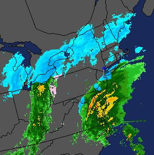
Classic Nor'Easter - Montreal on the northern edge
By tonight this low will become absorbed by a much larger system that is taking shape this morning along the North Carolina coast. That storm will move towards Cape Cod while deepening rapidly. This will be a major blizzard for New England and Atlantic Canada with 100km/h (60mph) winds and 1 to 2 feet of snow. Already this morning delays and cancellations are pouring in. Coastal flooding will be a big issue from Massachusetts along the coasts of New Hampshire, Maine and Nova Scotia. Large, damaging waves will surge in along the coast.
With the snow affecting such a large area in the east, air travel will be severely disrupted - call ahead. Also, if you are thinking about driving to Ottawa, Toronto or Boston today, I would strongly advise that you don't.
Subscribe to:
Post Comments (Atom)

No comments:
Post a Comment