 |
| Mild air and rain will return once again by Wednesday in Montreal. |
After a rainy and very mild Sunday, record high temperatures have already been established this morning in Toronto, 10.4C (51F) and Burlington, Vermont at 11C (52F). Close to home, St Anicet reached 11.1C (52F) in the pre-dawn hours, shattering their record of 5.5C from 2002. We managed 9.4C (49F) here on L'Ile Perrot and 8C (48F) at Trudeau, just a notch below the record high of 10.3C set in 1988. The normal high should be -5C (23F). We have likely reached the daytime highs for the day, as a cold front is about to move into eastern Ontario and southern Quebec. Gusty winds up to 60km/h are possible up to the noon hour today in the St. Lawrence Valley, along with falling temperatures back to the freezing point by later this afternoon. Some showers are possible, but it will be dry for most of the day.
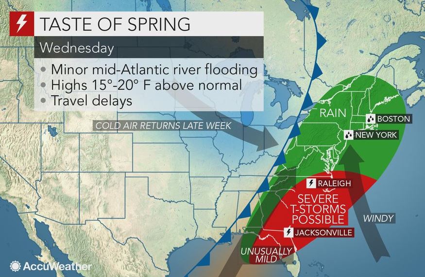
Tonight will be partly cloudy and much colder as high pressure briefly nudges into the area. Temperatures will drop to -9C (16F), so Tuesday morning will feel very different from this morning. Tuesday is also Groundhog Day, when furry rodents all over North America take over the forecasting duties. More on that later today. After a sunny day on Tuesday with a high of -3C (27F), our attention will turn to a developing storm over the US Rockies. This strengthening system will move towards the Great Lakes and eventually western Quebec. Another surge of moisture and mild air will arrive late Tuesday night and early Wednesday. At this time, we are expecting a snow and rain mix to transition to all rain by Wednesday as temperatures rise well above freezing. The timing and any possible problems with freezing rain still have to be ironed out. I will post an update on this storm later today. By the end of the week, much colder air will return with a few flurries.
No comments:
Post a Comment