Tuesday, October 18, 2016

Record warmth followed by mountain snow

Much colder air will bring us back to reality this weekend. (AccuWeather.com)
Record warmth surged into upstate New York, eastern Ontario and southern Quebec on Tuesday. The temperature reached 28.2C (83F) in Saint-Anicet, surpassing the previous record of 26.4C set in 1998. Saint-Anicet, located less than 75km southwest of Montreal, was the warmest location in Canada today. Sainte-Clotilde, just south of Montreal, reached 28C as well. Saint-Hubert posted a record 24C (76F), smashing the old record of 18.8C (65F) set in 2007. The high temperature at my home on L'Ile Perrot, reached just before 4pm, was 26C (79F). Trudeau Airport settled for 24.2C (76F), just short of the record of 25C (77F) set in 1968.

SNOW
A weak cold front will cross the area this evening, accompanied by showers and perhaps some thunder. Weak high pressure will provide Montreal with sunny and cooler weather for Wednesday. Expect highs to be near 16C (61F). Strong low pressure is forecast to develop Thursday across the Ohio Valley, and move into southern Quebec by Friday. Clouds will thicken early Thursday, followed by an extended period of rain through Saturday. The rain could be heavy at times, with the possibility of more than 50mm falling. As the system pulls to our east, cold air will wrap around the backside of the storm on strong northwest winds. The coldest air of the season will arrive in southern Quebec, with highs no better than 8C (47F) this weekend, and overnight lows close to the freezing point. Some snow is possible over the higher elevation of New York and Vermont, as well as the Townships and Laurentians. It is also quite possible that 10-20cm of snow could fall between Jay Peak and Mount Mansfield in the Green Mountains, late Saturday and Sunday. Some snow may occur northeast of Montreal. A few wet snowflakes may even fall in the St. Lawrence Valley Saturday night. Warnings may be needed as the event draws closer.

Monday, October 17, 2016

Warm, windy, wet week ahead for southern Quebec

The frontal rain predicted for late Sunday arrived a few hours earlier and put a damper on outdoor activities to end the weekend. Close to 13mm (0.5 inches) of rain fell in Montreal. Despite the clouds and rain, temperatures remained warm. The high on Sunday was 18C (65F), while the normal high/low should be 12/3C. As the cold front clears southern Quebec this morning, look for sunshine to develop along with mild temperatures, highs near 16C (60F). A warm front will lift north into the St. Lawrence Valley tonight, with clouds increasing near sunset. Showers with perhaps a rumble of thunder, are expected to develop after midnight. Temperatures will again be mild, near 10C (50F). Tuesday will be an unseasonably warm and windy day, with high temperatures into the middle 20's, depending on how much sunshine develops. Gusty southwest winds will exceed 50km/h in Montreal. Cooler unsettled weather is forecast by the end of this week, with more October-like temperatures dropping into the single digits, and perhaps a decent amount of rain by Friday and Saturday.

A large tree lies across a home in southern BC, after 100km/h wind gusts hit the region from Friday through Sunday. (TWN/Twitter Abbotsford Police)
Stormy West
While it has been rather quite and mild in eastern Canada, the west has been stormy and, in some cases, snowy. Several October snowstorms have impacted Alberta and Saskatchewan. Heavy snow fell last Friday in Edmonton, resulting in numerous accidents from unprepared drivers. Amounts ranged from 10-20cm across central Alberta. On the B.C. coast, strong winds gusted over 100km/h, producing pounding surf and toppling trees and power lines. Widespread damage was reported from southern B.C. into Washington and Oregon. A total of three storms knocked out power to over 200,000 B.C. homes. Ferries were cancelled and at least one fatality was reported. Between 100 and 300mm of rain has fallen during the three-storm event.

Friday, October 14, 2016

Frosty start to the weekend in Montreal, then warmer

Montreal continues to have a very warm and dry fall, despite the recent showers. On Thursday, 4 to 7mm of rain fell in the region, along a brisk cold front, bringing the monthly total to 19.6mm here on L'Ile Perrot. That amount is less than 50 percent of the normal for the month of October, a trend that has been persistent all year. Temperatures have also been quite mild. However, we did manage our first frost of the year this week. I recorded my first sub-zero temperature of the season here on L'Ile Perrot Friday morning at -1C (31F). A decent frost occurred as well, at least in my neighbourhood.

Strong high pressure will move into the region today and crest over New England this weekend. Conditions will be sunny through Sunday in Montreal, with high temperatures near 12C (54F) today. The temperature will warm into the upper teens and even low 20's by Sunday. Another cold front will bring the chance of showers Sunday night into Monday. Looking ahead to next week, the same pattern remains in place, with warmer-than-normal temperatures and just a chance of light precipitation early in the week and again by Friday.

A spectacular NASA image of Hurricane Nicole approaching tiny Bermuda on Thursday. (NASA Goddard MODIS Rapid Response Team Image)
Hurricane Nicole
Powerful hurricane Nicole became one of only seven such storms to pass within 40 miles of Bermuda since 1851. The tiny island was dwarfed by the massive storm on Thursday. Winds gusted in excess of 120mph, with widespread damage reported. Roofs were torn from homes, power poles were snapped, and flooding was reported. Power is out to most of the island. Thankfully no fatalities have been reported thus far.

Tuesday, October 11, 2016

Matthew's misery spreads from Haiti to Newfoundland

Heavy rain produced widespread flooding in Newfoundland and Nova Scotia on Thanksgiving Day. Above is a street in Sydney on Monday afternoon. (TWN/@redbatgirl)
Hurricane Matthew's parting shot at North America occurred Monday, as a moisture-fueled front dumped several months worth of rain in one day on Nova Scotia and Newfoundland. A state of emergency has been declared in several portions of both provinces, after 100 to 225mm of rain fell in 24 hours. Halifax reported 102.8mm, Eskansoni 199.3mm and Sydney 224.8mm. In Newfoundland, 180mm fell at Burgeo. The torrential rain produced widespread flooding of homes and businesses, as well as the collapse of several roads. Schools are flooded in many cases and, as a result, closed today.

Matthew moved into South Carolina on Saturday, before exiting the coast Sunday and merging with a cold front along the east coast. The front drew moisture north into New England and Atlantic Canada.

In Fayetteville, the North Carolina National Guard preforms a water rescue, one of thousands in that state. (@NCNationalGuard)
The death toll from Matthew is approaching 1000, including 23 in the US. Of those, nearly half occurred in North Carolina, where a combination of surge and fresh water flooding has produced catastrophic damage. On the Outer Banks, a record storm surge washed away roads and homes. In Fayetteville, firefighters and the National Guard were forced to perform thousands of water rescues. Power outages continue for hundreds of thousands of residents from Florida to Atlantic Canada. Matthew has produced an estimated $6 billion in damages in the US alone. In Haiti, residents are trying to piece together what little they have left, with relief agencies making a desperate plea for help. Thousands are homeless, with over 900 dead from Matthew. There are now fears of a cholera outbreak in the wake of the storm.

Saturday, October 08, 2016

Hurricane Matthew crawls into the Carolinas

Happy Thanksgiving! Smoke Meat Pete on L'Ile Perrot decorated for the season during Friday's spectacular weather. (ValleyWeather Photo)
Hurricane Matthew has been the focus of my columns this past week, and as a result I have been a little negligent on the home front. I have a preoccupation with hurricanes that goes back decades. Despite the rain this morning in southern Quebec, our weather continues to be warm and dry. Rainfall since late August is running at less than 50 percent of the normal. Temperatures have continued to be well above normal, including 25C (77F) on Friday. A cold front today is producing showers that will continue into Saturday afternoon. Noticeably cooler air arrives for Sunday and Thanksgiving Day, with temperatures closer to the normal high/low of 14C and 4C.

Twitter@JimCantore

Damage was extensive from Hurricane Matthew in the Daytona Beach area as well as northeast Florida. (TWC/AP Photo)
Hurricane Matthew
Hurricane Matthew's death toll continues to rise sharply with each passing hour. The storm is responsible for over 900 fatalities as of Saturday morning, including 4 in the US. Hard hit Haiti is reeling from torrential rains and mudslides, after a direct hit from Matthew. Florida has reported significant damage, especially along the northeast coast. The eye of the storm remained offshore this morning, but a tremendous surge of water has produced record flooding in some coastal locations. This morning a weakening Matthew, with 85 mph winds, is located 20 miles southeast of Charleston, South Carolina. The storm surge continues to be the big story, with 5 to 7 feet of water flowing into the South Carolina coast. Surge flooding and torrential rains will move into North Carolina as the day progresses. Over 1 million southeast US residents are without power this morning. Numerous coastal roads including the A1A in Daytona Beach, have been heavily damaged. South Florida escaped the worst of the storm.

One last check of the beach, before the storm surge inundated the coast at Jacksonville, Florida (AP Photo)

Thursday, October 06, 2016

Millions evacuate Florida's east coast ahead of Matthew

NOAA Satellite image of Hurricane Matthew, 215 miles southeast of the Florida coast Thursday morning.
Hurricane Matthew has been pounding the Bahamas for over 24 hours now. The center of the strengthening hurricane is located 215 miles (350km) southeast of West Palm Beach, Florida this morning. Millions of residents have been ordered to evacuate the coast, from Miami northward toward Jacksonville and beyond into Georgia and South Carolina. A hurricane warning is in effect, with the center of Matthew forecast to skirt the coastline through late Friday. Winds in excess of 125mph can be expected along Florida's east coast starting this evening. Heavy rain and a storm surge in excess of five feet are also expected along the southeast US coast.

Hurricane Matthew is currently a Category 3 storm, but forecast to strengthen to a Category 4 storm as it approaches Florida late today. Overnight winds gusted to 145mph in the Bahamas. Already this morning, Matthew is looking better organized on radar and satellite, with a deepening pressure to 939mb in the center of the storm. If Matthew comes ashore, it will be the first major hurricane to make landfall in the US since Wilma in 2005.

Damage from Matthew has been extensive in Cuba and Haiti. At least 27 fatalities have been reported across the Caribbean. Many portions of Haiti remain isolated, with flooding and no communications. Residents in coastal communities up and down Florida's east coast spent much of Wednesday boarding up, stocking up on supplies, and heading inland. A state of emergency has been declared in numerous coastal counties from Florida to North Carolina. Matthew is expected to linger along the coast during the upcoming weekend, before weakening and looping into the Atlantic, east of South Carolina.

Wednesday, October 05, 2016

Next up for hurricane Matthew: Florida and The Bahamas

Flooding is being reported today in Nassau, Bahamas, well ahead of Hurricane Matthew. (TWC/AP Photo)
Hurricane Matthew continues to be a very dangerous hurricane Wednesday afternoon. The center of Matthew is located 165km (105 miles) south of Long Island in the Bahamas. The storm is responsible for at least 11 fatalities in Haiti and Cuba, with that number expected to rise. Many locations in far western Haiti have reported widespread destruction. Homes were levelled in many villages, with major flooding reported and bridges washed out. Communications are down and thousands are homeless in the poorest country in the Western Hemisphere.

Hurricane warnings are in effect across the Bahamas, as well as the east coast of Florida, inland to central portions of the sunshine state. Evacuations have been ordered in many coastal communities from Florida to the Carolinas. Forecasters expect Matthew, currently a Category 3 storm with 120mph winds, to strengthen once again this afternoon. Matthew is expected to move through the Bahamas today and tonight, and along the Florida coast late Thursday. By Friday, the storm is expected to loop out into the Atlantic, east of South Carolina. Earlier forecasts had the storm moving up the entire east coast into Nova Scotia and Quebec this weekend. Current models are painting a much different scenario today, having the storm slow down and even move back towards Florida. Matthew will need to be monitored very closely by all east coast residents over the next few days. A state of emergency has been declared in several coastal counties from Florida to South Carolina. There has been a rush on water, gas, generators, batteries and anything else deemed useful to ride out this powerful storm.

Tuesday, October 04, 2016

Hurricane Matthew making landfall in Haiti

NOAA satellite image of hurricane Matthew just prior to landfall in western Haiti Tuesday morning. The eye is visible in the center of the image, nearing Tiburon, Haiti.
Powerful hurricane Matthew is making landfall Tuesday morning near Tiburon in western Haiti. Matthew intensified overnight, with maximum sustained winds now of 145mph gusting to 185mph. The eye of the storm increased in diameter as well, allowing the hurricane to look quite impressive on satellite and radar images this morning. Matthew is the first Category 4 storm to make landfall in Haiti since Cleo in 1964. Cleo was responsible for 132 fatalities in Haiti. A weather station in coastal Haiti reported a wind gust to 107mph this morning before it stopped transmitting. Haiti Libre reports major coastal flooding from the storm surge, as well as mudslides. One fatality was reported so far.
Hurricane Matthew will continue to impact Haiti and Jamaica today, with hurricane conditions spreading north into Cuba tonight. Torrential rain over the region, in some cases in excess of 40 inches, is possible. Rain of this magnitude will likely liquify soils, producing widespread flooding and mudslides across Haiti into the Dominican Republic.

Matthew is forecast to move north and then northwest over the next few days. This will bring the center of this dangerous storm into the Bahamas Wednesday, and eventually towards coastal Florida and the Carolinas by late Thursday and Friday. A hurricane watch may be needed later today for a portion of the Florida coast, including the Keys. By this weekend, hurricane Matthew will be moving close to the New England coast, with perhaps direct impacts here in southern and eastern Quebec, as well as Atlantic Canada into Thanksgiving Day. Plenty has to happen before then, but all interests from Florida to Nova Scotia should monitor the progress of Matthew.  

Sunday, October 02, 2016

Powerful Hurricane Matthew heads north towards Jamaica

The view of Hurricane Matthew from inside the US Air Force C-130 Hurricane Hunter. (Twitter@53d_HHA)
Hurricane Matthew started a slow turn to the northwest Sunday morning. The 13th storm of this busy Atlantic hurricane season is also the strongest since Felix in 2007. On Saturday morning, Matthew attained the strongest Category 5 status, with 160mph winds. The storm has since settled back to 150mph winds, with gusts to 185mph, making it a Category 4 storm on the Saffir Simpson Hurricane Scale. Hurricane warnings have been posted for Jamaica, Haiti and eastern Cuba. A hurricane watch is in effect for the Bahamas. All interests up and down the east coast from Florida to Nova Scotia should monitor the track of Matthew during the upcoming week.

The National Hurricane Center forecast track of Hurricane Matthew through the southern Caribbean. (NHC)
On Sunday morning, a US Air Force C130 Hercules Hurricane Hunter aircraft reported the center of Matthew 315 miles (510km) south southeast of Kingston, Jamaica at 8:00 a.m. Matthew is moving northwest at 5mph. The storm is forecast to maintain a slow trip north, taking the center across western Haiti or eastern Jamaica and into eastern Cuba over the next 36 hours. Beyond then, the storm may impact the US coast late in the week. Preparations are being rushed to completion in Jamaica and Haiti. Along with the wind and storm surge, torrential rain is forecast; in some cases, over 20 inches (500mm) of rain is possible. This type of rainfall over the mountainous portions of Haiti has, in the past, resulted in deadly flash flooding and mudslides.

Friday, September 30, 2016

Major flooding in southwest Ontario and Michigan

A state of emergency has been declared in Essex County, Ontario after two days of torrential rain. (Windsor Star)
A stubborn upper-level low stalled over the Ohio Valley continues to pump deep moisture off the Great Lakes, across southwest Ontario and Michigan. On Thursday, more heavy rain fell across the area, with nearly 160mm in Tecumseh, south of Windsor. Officially, 85mm fell at Windsor Airport, with over 120mm in nearby Detroit. The normal rainfall for the entire month of September is 91mm in Windsor. The rain produced widespread flooding on roadways and in basements. Rivers are on the rise as well, with many exceeding flood stage. A state of emergency has been declared in Essex County, Ontario. More rain is forecast today, with another 50-75mm possible. Across the river in Detroit, the situation was much the same, with major highways closed and water rescues underway. The storm causing the rain will slowly drift southeast before lifting north again this weekend. Cloudy skies and showers are forecast across the Northeast, New England, southern Quebec and Ontario. The heaviest rain will remain south and west of Montreal.

Hurricane Matthew
Matthew strengthened into a hurricane on Thursday, with the center located 535 miles southeast of Kingston, Jamaica Friday morning at 5:00 a.m. Matthew is moving west at 14mph, with 100mph winds. Additional strengthening is expected today, and Matthew could become a major hurricane. The forecast track will take the system west for the next 36 hours before turning north towards Jamaica and Cuba by late Sunday. By the middle portion of next week, Matthew is forecast to be near the Bahamas. The storm may then threaten the east coast of the US and Canada, but it is too soon to determine where and to what extent. Additionally, the possibility does exist that the storm could be swept out to sea, missing the east coast.

Wednesday, September 28, 2016

September warmth to continue into October

A slow-moving upper-level low pressure area will persist across our region through the weekend. Montreal will remain on the edge of the system with frequent clouds and showers, but also some breaks.

According to the National Oceanic and Atmospheric Administration (NOAA), August was the 16th consecutive month with temperatures above average globally. This has not occurred over the last 137 years; basically, it has been exceptionally warm. August was 1.66F above the 20th Century average, eclipsing the record set just last year. The average temperature for 2016 to date is 1.82F above the long-term average. In Montreal, we experienced the second-warmest June-to-August period on record. The warmth continued into September. So far, the monthly average is 17.8C, above the normal of 15.5C. It has been extremely dry once again, with only 31.2mm of rain this month, compared to the normal of 83.1mm.

For the short term through the start of October, we are expecting temperatures to remain slightly above average. Stubborn low pressure will very slowly move from the central Great Lakes southeast towards southern New York. The system will then lift north again into eastern Ontario. Southern Quebec should remain on the periphery of the moisture, with showers forecast Saturday and Sunday, but not a washout. Gusty northeast winds will prevail through the end of the week as well, making it feel a little cooler than the advertised highs. Several mornings this week have featured a marine layer of clouds and fog generated by the northeast winds channeling down the St. Lawrence Valley.

Tropical Storm Matthew
Tropical storm Matthew has formed in the Atlantic Basin, 40km southwest of St. Lucia. Matthew is moving west at 20mph (31km/h), with 60mph (100km/h) winds. This storm is forecast to strengthen and become a hurricane by Friday. Forecasters then expect Matthew to turn to the north and impact Jamaica. Beyond then, there is the potential the storm could affect the Gulf Coast or even the eastern seaboard.

Thursday, September 22, 2016

Summer snow for Lake Louise, warm in Montreal

Heavy wet snow greeted visitors to Lake Louise, Alberta on the last full day of summer. (Lake Louise Ski Resort Photo)
The last full day of summer was spectacular across southern Quebec and Ontario. Plentiful sunshine, gusty southwest winds and warm temperatures prevailed, with highs reaching 27C (80F) or better in many locations across southwestern Quebec. Humidity levels were elevated, making it feel more like mid-summer. Montreal should be around 20C (68F) for late September. While we were enjoying August-like weather here in the east, an upper-level low and cold northerly flow produced a widespread summer-snowfall across the foothills of Alberta. As much as 32cm fell across the higher elevations near Banff, with over 30cm at Sundre. A cold rain fell east of the foothills towards Calgary.

The coolest air so far this September will invade southern Quebec this weekend. (AccuWeather Graphic)
First Day of Autumn
Fall officially arrives at 10:21 a.m. Thursday morning, with cooler weather and clouds forecast to greet the season. Today will still feature above-normal temperatures in Montreal, just not as warm as it has been. Expect high temperatures in the low to middle 20s. A cold front will move from north to south across southern Quebec tonight and into New England on Friday. Expect a period of steady rain along the front, followed by gusty north winds and much colder temperatures. Highs on Friday will only be in the upper teens. High pressure will settle into Quebec Saturday and remain through Monday. The forecast will be cooler than normal for the first time this month. Highs on Saturday and Sunday will only be around 15C (59F), with lows down to 7C (45F) in the city, but much colder in outlying regions. Some locations may even see scattered frost early Sunday and Monday morning. Briefly looking ahead to next week, warmer weather will return, with temperatures once again surging above normal in Montreal.

Monday, September 19, 2016

Warm September continues across southern Quebec

Warm, muggy weather will dominate the east coast and southern Quebec once more this week. (AccuWeather)
The hot and dry summer across southern Quebec has stretched right into September. With two thirds of the month in the record books, the average high temperature has been a sweltering 24.3C (76F), the normal should be 20.6C (69F). To date 18 of the 19 days in September have featured above normal temperatures. This trend continues Monday morning, with Montreal at 9 a.m. reporting 21C (70F), the warmest location in the country. Partly sunny skies and humid conditions are forecast today through Wednesday, with high temperatures well above normal at 26C (79F). The normal high for September 19, should be 18C (65F) for Montreal. With the exception of a couple of nights, the overnight lows have been very mild as well, averaging 13.5C (55F), the normal should be 10.3C (50F).

There has been a slight improvement in the drought conditions in southern Quebec after the rainfall of late August. September however has been very dry once again, with only 23.4mm of precipitation so far. Montreal normally receives 83.1mm of rainfall for September. We have plenty of catching up to do. Showers and thunderstorms over the weekend missed Montreal, with only 3 or 4mm falling in the city. The next chance for rain will come along a cold front Thursday. Cooler, more seasonable weather is expected to arrive by next weekend. However it will be short lived, as the much warmer than normal Great Lakes continue to modify the cooler fall air as it moves southeast from northern Canada.

Friday, September 16, 2016

Spectacular Harvest Moon Friday night in Montreal

The full Harvest Moon rises over the St. Lawrence Seaway in September 2015. (ValleyWeather Photo)

Another chilly morning greeted early risers on Friday, as temperatures settled into the middle single digits across southern Quebec, 6C (43F) here on L'Ile Perrot. Some locations across the Adirondacks and Laurentians dropped very close to the freezing point, with scattered frost reported. We can expect another sunny day, with seasonable temperatures of 22C (72F) here in Montreal. The weekend is looking unsettled, as a moisture-laden frontal system approaches Quebec form the Great Lakes. We can expect increasing clouds Saturday, followed by showers and thunderstorms through Sunday. Temperatures will be rather mild, with highs in the middle 20s and lows in the teens. Winds will be gusty both days this weekend.

HARVEST MOON
The Harvest Moon is the full moon closest to the Autumnal Equinox. Fall arrives on September 22 at 10:21a.m. ET, making Friday night's full moon this years harvest moon. The Harvest Moon has always been the biggest, brightest and earliest-rising full moon in the sky all year long, appearing shortly after sunset. Through the year's, farmers have relied on that moonlight to lengthen the short work days of late summer and early fall, allowing them to continue with the harvest late into the night.

This year, some will be treated to an additional celestial show. The full Harvest Moon will also feature a Penumbral Lunar Eclipse. While not as spectacular as the full lunar eclipse in September 2015, it should still be a sight to see. The moon will take on a spooky glazed look as it passes through the Earth's shadow. While conditions will be clear in eastern Canada, the eclipse happens early in the day and will not be visible here in Montreal. The full moon rises at 7:12 p.m. in Montreal. The eclipse will be visible across Europe, Africa, Asia, Australia and the Western Pacific. It will last 3 hours and 59 minutes, reaching its peak at 18:54 UTC (2:54 p.m. in Montreal).

Monday, September 12, 2016

A touch of fall in the air for Ontario and Quebec

A tree crushes a car in north end Montreal early Sunday morning. (CTV News Montreal)
Monday morning Southern Quebec awoke to a fresh air mass and the coldest temperatures since last May, 9C (48F) here on L'Ile Perrot. This comes after an active weather weekend across eastern Canada. Saturday was extremely humid, with summer-like temperatures rising into the high 20s and, in some cases, over 30C. Combined with the humidity, the atmosphere was juiced as a strong cold front arrived overnight into Sunday. The front generated widespread severe thunderstorms that swept across the St. Lawrence Valley from Kingston to Montreal and northeast towards the Saguenay. Winds gusted in excess of 70km/h in Kingston and Brockville, with a 69km/h gust reported at Trudeau Airport in Montreal. The wind toppled numerous trees onto cars and homes. Power lines were also damaged, with 60,000 Hydro Quebec customers across the province without power at the height of the storm. Over 150 crews and contractors worked through Sunday restoring power. As a result less than 1000 customers remain in the dark as of Monday morning. The thunderstorms also produced spectacular lightning in and around Montreal through the wee hours of Sunday morning, with over 30 strikes per minute in some cases. Funnel clouds were observed in southeastern Ontario, prompting a tornado watch.

A spectacular shot, taken by Kingston Police, of  lightning accompanying one of the storms Saturday night in Kingston, Ontario.
The front ushered in the first real fall-feeling air mass of the season. Temperatures remained in the teens on Sunday here in Montreal, along with a brisk northwest wind. This morning, skies are clear and it is fresh to say the least. The temperature dropped to 11C (52F) at Trudeau Airport, 9C (49F) here in Vaudreuil/Dorion, but as cold as 3C (39F) across the Laurentians and Adirondacks. The start of the week will be perfect, with lots of sunshine, low humidity and temperatures in the middle 20s. Clouds, along with showers and thunderstorms, arrive Wednesday, before conditions improve Thursday. Temperatures will cool once again to end the week.

Thursday, September 08, 2016

Late-summer eastern heatwave

Tropical depression Hermine continues to dissipate off the east coast, while warm and humid air flows north into eastern Canada. (AccuWeather Map)
It feels like mid-August this morning in southern Quebec, with the current temperature already higher than our normal daytime high for early September. Montreal is currently 22C (72F), on our way to a high of 28C (83F). The overnight low was 21C (70F), over 10 degrees Celsius above normal. It is very muggy out after 4.2mm of rain overnight. Wednesday was sunny and hot across most of eastern Canada, from Ontario to Newfoundland. Montreal was nearly 30C (86F), while Toronto set a new high temperature record for the date at 35C (95F). The previous record dates back to 1960 at 33.9C (94F). New high temperature records were also established right across Atlantic Canada, including Newfoundland. Badger, Newfoundland recorded a new record high of 27.4C (81F). In Grand Manan, New Brunswick, the mercury hit 25.3C (78F) to tie the record for the date. Data at that location dates back to 1883, so this is significant warmth we are experiencing for September.

The webcam at Sunshine Village near Banff, Alberta, shows an early-season snowfall on Wednesday. (skibanff.com)
For those looking for cooler fall weather, you may have to wait another week or so, or travel to western Canada. Low pressure and a cold front will give Montreal a breezy, muggy day today, with showers and thunderstorms. Skies will clear briefly on Friday, but the weather will remain warm and a little humid. Another round of showers and thunderstorms is likely Saturday afternoon into Sunday, before high pressure returns. Sunshine will prevail to start next week. Temperatures in Montreal next week should remain well above the normal high of 21C (70F) and normal low of 10C (50F). The current heatwave covers most of the eastern United States as well, with high temperatures in the upper 80s and 90s and heat index values above 100F (37C) from the deep south into New England.

Meanwhile it is much cooler out west. Snow fell on Wednesday at Sunshine Village near Banff, as the temperature was just above the freezing point. More snow is possible next week, as a strong cold front is forecast to sweep the region.

Monday, September 05, 2016

Hermine blasts the Outer Banks - spares Jersey Shore

Major flooding was reported on Hatteras Island, North Carolina this past weekend from tropical storm Hermine. (TWC)
After hammering the Outer Banks of North Carolina through Sunday morning, Hermine is drifting slowly north this morning, 305 miles southeast of Long Island, New York. The Jersey Shore is breathing a cautious sigh of relief on this Labour Day Monday, having been spared so far. The storm continues to show signs of strengthening, currently with 70mph winds. Tropical storm warnings are posted for the Long Island coast, as well as eastern Massachusetts. High surf advisories are posted northwards into New Hampshire and Maine. Interests in Nova Scotia and coastal New Brunswick should continue to monitor Hermine.
Highway 12 on Hatteras Island, North Carolina, under water on Saturday, September 3. (AP Photo)
This storm has been difficult to forecast since day one. Hermine is expected to meander off the east coast through at least Wednesday, before moving northeast, south of Atlantic Canada, and out to sea. The threat for heavy surf continues today for the northeast US coastline from Delaware to Maine, but little inland effects are expected at this time. The catastrophic flooding forecast for the Jersey Shore has not materialized at this time. However there is still a risk of high surf and flooding at each high tide through mid-week from New Jersey northward. Residents are urged to continue to monitor this fickle storm.

Hermine is blamed for at least two deaths, one in Florida and a second on the Outer Banks. The storm blasted the Outer Banks on Saturday, with winds in excess of 80mph and severe flooding. Water was 5 feet deep in several villages on Hatteras Island after the Pamlico Sound spilled onto the island on the back side of Hermine. Roads were submerged and homes and businesses took on water. Conditions are slowly improving on the Outer Banks today, as crews begin yet another major clean-up of coastal Highway 12. Further north, dunes were destroyed in Nags Head and Kitty Hawk, with severe beach erosion reported.

Montreal
Meanwhile, the weather is perfect here in southern Quebec. What you see is basically what you can expect through mid-week. Strong high pressure is keeping Hermine off the coast, providing spectacular sunshine and warm temperatures in the upper 20s. This is followed by cool, crisp nights, with lows in the lower teens.

Saturday, September 03, 2016

Hermine expected to batter US east coast for days

Hurricane Hermine caused major damage along the Florida Gulf Coast Friday morning before moving north into the Carolinas. (TWC/Getty Images)
Tropical Storm Hermine is going to be kept at bay to our south this weekend, by strong high pressure centered over Quebec. That high pressure will provide sunny, tranquil weather for southern Quebec and northern New England. Further south along the southern New England and Mid-Atlantic coasts, it will be a very different story.

This morning, Hermine is located 60 miles west northwest of Hatteras, North Carolina. The Outer Banks took a beating overnight, with heavy rain, in excess of 125mm (5 inches), as well as 60 mph winds and pounding surf. A tornado was reported on Hatteras Island, damaging a campground with minor injuries reported. From Florida to Virginia, hundreds of thousands are without power. So far one fatality has been reported from Hermine. Tropical storm Hermine is expected to move off the coast back into the open waters of the Atlantic later today. The storm will undergo some rather technical transformations over the next 24 hours, however she will remain a very dangerous storm. With the lessons learned from Hurricane Sandy, the National Hurricane Center will continue to provide updates on the storm, regardless of whether she is tropical, post-tropical or extra-tropical.

The projected track of Hermine has her stalling off the Jersey Shore this weekend. (NHC)
Call her what you want, the coast from Delaware to Long Island will be hammered for days during successive high tide cycles. The fear is for Sandy-like damage to coastal infrastructure in many locations. This holds especially true for the Jersey Shore. The storm will meander off the coast through at least Tuesday and perhaps longer before being swept out to sea.

 I will provide frequent updates on Hermine throughout the holiday weekend via twitter @valleyweather2 and this blog. Stay safe.

Wednesday, August 31, 2016

Hurricane Hermine sweeps into Florida's Big Bend

Hurricane Hermine made landfall at 1:30am Friday morning near St. Marks, Florida. Damage is widespread in the Big Bend area of The Sunshine State. (NBC News)
A strengthening Hurricane Hermine roared into the Big Bend area of north Florida overnight, making landfall near St. Marks at 1:30am. The storm, which has been extremely difficult to predict, has now been downgraded to a tropical storm, 50 miles northeast of Tallahassee. Hermine leaves behind major damage and flooding along Florida's Gulf Coast from Tampa to Tallahassee. Early estimates place the storm surge at 9 feet as Hermine moved inland. Overnight winds gusted in excess of 80 mph along the coast, with isolated tornadoes. Numerous trees and power lines are down, with nearly 200,000 residents without power. Many roads have been closed as a result of flooding. Authorities had to rescue people early Friday morning who had attempted to ride out the storm along the coast. Remarkably, Hermine was the first hurricane to hit Florida since Wilma in 2005.

A spectacular image of a strengthening Hurricane Hermine (upper right) just prior to landfall in Florida early Friday morning. (NOAA)
Hermine is the little storm that could; Expected to become a tropical storm, a week ago, the system defied forecasters and remained as a depression well into the Gulf of Mexico, before turning abruptly north and rapidly intensifying on Thursday. Hermine is expected to remain a strong tropical storm with heavy rain and winds up to 70mph across the southeast and into the Middle Atlantic states this weekend. Weather warnings stretch from southern New Jersey to Florida. The storm may impact eastern Canadian weather next week, but it is too soon to determine exactly how far north she will go. Hermine is forecast to stall off the east coast near New Jersey next week.

Goodbye to meteorological summer

National Hurricane Center forecast map for soon-to-be tropical storm Hermine. The storm is forecast to impact Florida over the next 48 hours before heading up the east coast. (National Hurricane Center)

Today is the last day of the summer season as far as meteorologists are concerned. Thankfully, Mother Nature lingers a little behind, so we can still expect more summer weather here in Montreal, usually well into September. But the signs of autumn are there: the kids are back to school, leaves turning slightly, and longer, cooler nights producing heavy morning dew.

Looking back briefly at June through August, temperatures averaged above-normal values. Some locations in southern Quebec and New England are expected to show their warmest August on record. Until the middle of August, it was also a very dry summer in Montreal. That has changed in the last two weeks, with more rain falling this month than in the previous two combined. Overnight, Montreal added to the monthly total as scattered thunderstorms developed. More are possible later Wednesday, before we say goodbye to August. At this time, the long holiday weekend looks spectacular here in southern Quebec, sunny and seasonable, with high temperatures in the middle 20s.

Across North America, the weather has been extremely active of late. A powerful and rare summer low pressure area pounded Newfoundland Monday and Tuesday, with torrential rain and winds in excess of 130km/h. A wind gust to 121km/h in Twillingate was the strongest August wind on record for that community. The previous record was 107km/h, set in 2007. Strong thunderstorms this week have produced severe flash flooding in Ohio and parts of Colorado. Deep hail fell in Colorado Springs on Monday, requiring snow plows to clear the streets.

Satellite image of tropical depression 9, Wednesday morning over the Gulf of Mexico. This system is forecast to strengthen into tropical storm Hermine later today. (NOAA)
The Tropics
In the tropics, tropical depression 9 is still meandering in the Gulf of Mexico, 640km south of the Florida coast. This system is expected to strengthen into a tropical storm later Wednesday, and be named Hermine. Warnings are in effect for a portion of the big bend area of Florida, as well and the Atlantic coast northward into Georgia. Heavy rain, up to 300mm (12 inches), and 60mph winds are forecast over the next 24 to 36 hours. The storm is then expected to move back over Atlantic waters over Labor Day weekend. All interests up and down the east coast of the US into Atlantic Canada will need to pay close attention to the future path of this tropical storm. Further out in the open waters of the Atlantic, hurricane Gaston has become a major storm, with 115mph winds. Gaston is no threat to land at this time. Meanwhile in the Pacific Ocean, hurricanes Madeline and Lester are expected to pass dangerously close to Hawaii over the next 48 hours. Warnings are in place for Madeline, forecast to move just south of the Big Island early Thursday morning.

Sunday, August 28, 2016

The 5th Anniversary of Hurricane Irene

Torrential rain consumed many villages in central and southern Vermont, including Quechee shown above. (NWS)
August 28th is the 5th anniversary of the multi-billion dollar Hurricane Irene arriving in Quebec. Irene had humble beginnings as a weak area of low pressure off the west coast of Africa. The storm was the 9th tropical system of 2011, becoming the first hurricane of the season. Irene would sweep across the Bahamas as a major Category 3 hurricane before weakening and heading for the east coast. Irene made the first of two landfalls on August 27, 2011 at Cape Lookout, North Carolina, as a high end Category 1 storm.

By the time Irene would rain herself out over Atlantic Canada, nearly eight million east coast homes would be without power, and insurable losses would approach US$10 billion. Irene would cause extensive damage to coastal North Carolina, with a storm surge washing over portions of the Outer Banks. The storm then moved inland southwest of New York City and tracked across Vermont and into the Eastern Townships of southern Quebec. Along her path torrential rain would fall, with as much as 250mm (9 inches) in less than 24 hours. The resulting flash flooding would heavily damage numerous villages and towns across the Catskills of New York and into the Green Mountains of Vermont. The flooding in Vermont would be the worst natural disaster in that state since the flood of 1927. In the end, 49 fatalities were attributed to the storm, including one in Quebec. The raging Yamaska River east of Montreal washed out a section of road, contributing to the drowning of a motorist.

A satellite image from August 28, 2011 shows Hurricane Irene engulfing New England and southern Quebec. (NOAA)
In Quebec, Irene produced as much as 150mm (6 inches) of rain in the Charlevoix region and sections of the Beauce and Townships. In Montreal, 65mm (2.5 inches) of rain fell in less than five hours. Winds gusted over 100km/h in Quebec, including a peak gust of 113km/h on Ile d'Orleans. In Montreal, the highest gust was 90km/h. The wind and rain contributed to power outages, with nearly 250,000 Quebec homes in the dark. The power at my home on l'Ile Perrot was out for over 20 hours. Final damage estimates in Quebec exceeded $130 million.

Irene was one of the first storms that tapped into the wave of social media. The storm threatened a large population along the east coast of the US, and was therefore heavily publicized. New York City was shut down for an entire weekend. In the end, many felt the storm was over-hyped. Unfortunately, this drew attention away from Vermont and upstate New York, where Irene was one of the worst natural disasters on record. Irene proved just how devastating a low-category hurricane can be, especially to inland locations.

Thursday, August 25, 2016

The tropics are heating up

NOAA, National Hurricane Center image of Hurricane Gaston, and Invest 99-L (orange X) in the Atlantic basin. At this time, Invest 99-L has a better-than-even chance of becoming tropical storm Hermine. The storm could then impact south Florida as early as this weekend.
We are entering the most active period in the Atlantic hurricane season, which typically runs from June 1st to November 30th. Most of the storms occur within a six-week period from late August to early October, focused around Labor Day.

Forecasters at the National Hurricane Center in Miami, Florida are currently watching two systems in the Atlantic basin. Hurricane Gaston is a minimal storm with 75mph winds, located over 1000 miles east of the Leeward Islands, and not any threat to land. Gaston is expected to weaken over the next 24 hours as it moves into cooler waters. Of more interest this morning to forecasters and weather nerds alike, is an area of showers and thunderstorms dubbed Invest 99-L, just north of Puerto Rico. Depending on your weather model of choice, this low pressure area could become tropical storm Hermine this weekend and impact south Florida. Beyond that, different models are presenting very different scenarios. If the system develops, and that is still not certain, it could swing northeast out to sea, or impact the waterlogged central Gulf Coast as a strong storm next week.

In any event, I will be monitoring this storm closely, as I have been doing since 1979 when my interest in hurricanes started. Many of these storms impact eastern Canada with heavy rains and strong winds. Case in point: Hurricane Irene, whose 5th anniversary is coming up later this week. Irene generated over $1.5 million dollars in damage and one fatality in Quebec back in 2011. It was also the costliest natural disaster in Vermont state history. I will have much more on Irene later this week.

Monday, August 22, 2016

Autumn-like start to the week

Another spectacular warm and humid morning sky on L'Ile Perrot this past Friday, August 19. Summer will take a brief break today before returning Tuesday.
A wet and windy cold front on Sunday afternoon ushered in a brief taste of fall for southern Quebec. This morning temperatures are as cool as they have been at any time this month. It was 14C (56F) at 7am on L'Ile Perrot. The front also added to our quickly-recovering summer rainfall totals, with another 15 to 25mm falling on Sunday, 21.6mm here on L'Ile Perrot. That actually lifts us to close to normal precipitation since June 1st, with over 125mm (5 inches) falling in just the last week.

Today will be partly cloudy and fall-like, with a high temperature near 20C (68F) and very comfortable humidity levels. Clear skies tonight will allow for cool lows between 10C and 14C (50 to 55F) in southern Quebec. On Tuesday, warm southwest winds will return, along with high temperatures rising rapidly to 27C (81F). The balance of the week will see a return to warm and humid weather, with highs approaching 30C (86F) once again. The warm weather will last through Friday, before another cold front arrives with showers and thunderstorms. At this time next weekend looks sunny, warm and dry.

Wednesday, August 17, 2016

Record rainfall for Montreal

Torrential rain slowed the evening commute in Montreal. A record-setting 67mm fell on the city in less than five hours Tuesday night. (ValleyWX Photo)

Tropical rains fell across southern Quebec and Ontario late on Tuesday, with a record 67mm at Trudeau Airport in Dorval, most of that falling between 2pm and 9pm. That amount shattered the previous 24-hour record for August 16 of 49.5mm, established in 1966. It also rapidly brought the August total for the city from nothing to 119mm in just four days. The average August rainfall for Montreal is 94.1mm. Heavy rain and strong winds created widespread power outages across the region. As of early Wednesday morning, nearly 100,000 Hydro Quebec customers were in the dark. That number has since fallen to around 35,000 as of noon, August 17. Hydro Quebec has not specifically mentioned the cause, but a substation in Mercier-Hochelaga-Maisonneuve was flooded and knocked offline last evening.

The rain and poor visibility may have also contributed to accidents in which two pedestrians were struck by cars, in different parts of the city. Some underpasses were also flooded, but for the most part the water drained well. The ground has been parched lately and water levels have been very low, so the runoff was quick.

Other amounts of rain reported last evening included 58mm at my home on L'Ile Perrot, 77.8mm downtown at the McTavish recording station, 75mm at Oka, 90mm in Wiarton, Ontario, 58mm in Kemptville, Ontario and 26mm in Ottawa. South of the border in Vermont, heavy localized rain from thunderstorms washed out a section of Route 100 in Duxbury.

Warm and humid weather will now be with us through the weekend, with highs from 28 to 30C (83 to 86F) and warm lows near 20C (68F). The humidex readings will climb from the low to middle 30s by the weekend. Scattered thunderstorm activity is possible over the weekend, in the soupy air mass.

Tuesday, August 16, 2016

Heavy rain warning for Montreal

Heavy rain warnings have been posted for Ontario and Quebec. 
(AccuWeather.com map)

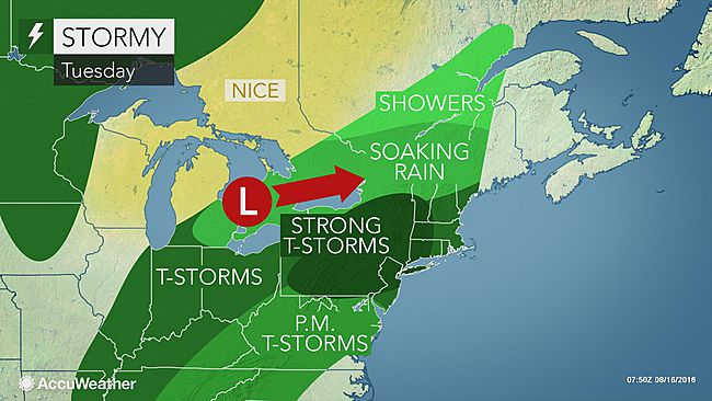
Widespread heavy rainfall warnings have been issued by Environment Canada for southern and eastern Ontario and southern Quebec. The same system that has created the devastating flooding in Louisiana will lift northeast across the Great Lakes and towards Quebec. The good news is that the system will be moving fairly quickly through our region. Rain will spread west to east across Ontario this morning and into Montreal later this afternoon. The rain will be heavy at times tonight, along with thunderstorms.

The death toll has risen to nine in Louisiana after nearly 25 inches of rain. Widespread historic flooding is occurring. The photo above is from Prairieville, Louisiana. (Photo via Twitter @presleygroupmk)

At this time, we can expect 40 to 60mm of rain across the region, with as much as 70mm locally. The heavy rain comes on the heels of the 50 to 100mm that fell over the weekend, however we are not expecting any major flooding. Southern Quebec and Ontario were bone dry for the past six weeks and water levels are very low. We should be able to absorb the new precipitation without incident. There may be some minor ponding of water in low-lying areas and on roadways. Temperatures will be rather warm and muggy, with a high of 25C (77F) today and 27C (81F) Wednesday. Overnight lows will be near 20C (68F). Skies will slowly clear in Montreal on Wednesday.

Monday, August 15, 2016

Heavy rain from Louisiana to Quebec and Ontario

Historic flooding across Louisiana has resulted in at least four fatalities and thousands of evacuations and water rescues. (Photo via Twitter @cbcnews)
What a difference a few hours can make when it comes to the weather. In less than 48 hours, many portions of southern Quebec and eastern Ontario recorded more rain than in the previous six weeks. Heavy tropical rains, along with embedded thunderstorms, swept along the edge of a large Bermuda high to our southeast. Southern Quebec reported 50 to 100mm (2 to 4 inches) of rain over the weekend, the heaviest along the Ottawa Valley, through Montreal and into the Townships. Here on L'Ile Perrot, I measured 78mm from late Friday to early Sunday. That included nearly 27mm in just a couple of hours, during a thunderstorm early Sunday morning. The normal monthly rainfall in August is 94.1mm for Montreal. Some severe weather was also observed, with tree damage in the eastern Townships, as well as minor flooding being reported. In Ontario, at least two tornadoes were confirmed on Saturday, including an EF-1 (150 to 175km/h winds) along the shores of Lake Simcoe.

LOUISIANA FLOODING
The soupy weather across eastern North America is the result of a large Bermuda high sitting off the east coast of the US. This system is pumping extremely warm and humid air north and west. Searing heat has been gripping the large east-coast cities of the US, as well as southern Ontario. We had a break on Saturday, as clouds and rain managed to keep the temperatures down here in Montreal. Along the edge of the high is a conveyor belt of moisture running from the Gulf of Mexico into Quebec. Therefore the closer to the Gulf, the more rainfall. Unprecedented historic flooding is occurring in Louisiana, with a least four fatalities reported. Thousands of water rescues have occurred, in addition to tens of thousands more evacuated. The flooding was the result of nearly 2 feet of rain in less than 48 hours. Damage is widespread across the state, including the closure of Interstate 10.

After the severe drought conditions of the last month, more rain is expected in southern Quebec late Tuesday and Wednesday, with perhaps another 25 to 50mm. Temperatures will warm up again for Monday, reaching 28C (83F) this afternoon in Montreal.

Thursday, August 11, 2016

Much needed rain this weekend

Tropical moisture may help alleviate some of the drought conditions in Ontario and Quebec this weekend. (AccuWeather.com Map)
7AM Friday Morning Update: A few weak thunderstorms this morning deposited a few millimetres of rain on L'Ile Perrot and Montreal. This was the first precipitation in 18 days. More rain is expected this weekend, possibly heavy at times. A flood watch is in effect for northern New York and Vermont. The same conditions prompting that watch state side, will exist in southern Quebec, with 25 to 75mm (1 to 3 inches) of rain possible through Sunday. Temperatures will be warm all weekend, in the middle 20s, and it will be very muggy.

Previous post below:
It remains hot and humid across eastern Canada this week, but with no rain here in southern Quebec. The last rainfall in Montreal was way back on July 25th. Hot weather has returned this week, with daytime high temperatures well into the 30s on Wednesday. Montreal fell just shy of the 1944 record of 32.8C (91F), with a high of 32.5C (91F) recorded at Trudeau Airport. Ottawa reached 35C (95F), and Toronto a scorching 36C (97F).

Thursday will feature the exact same weather, but more oppressive, as humidity levels rise. Overnight temperatures in Montreal remained uncomfortable, in the low-to-middle 20s, with highs today expected to reach the low-to-middle 30s. Combined with the humidity, the humidex or real feel temperatures will reach 40C (104F). Starting Friday, deep tropical moisture will lift north from the Gulf of Mexico. As it interacts with a front over eastern Canada, heavy rainfall is possible. The rain will come in waves, along with very muggy temperatures. Expect showers and thunderstorms from Friday through Sunday. It will not rain all the time, but when it does, it could be rather heavy at times, with some local flooding. The possibility exists for 25mm to as much as 75mm of rainfall in some locations across eastern Ontario, southern Quebec and New England. The rain will be beneficial to the moisture-starved vegetation. Temperatures will remain warm, but not as warm as we have experienced, due to thick cloud cover. Highs in Montreal will range in the middle 20s, with lows in the upper teens.

Monday, August 08, 2016

Drought conditions worsen in Quebec and Ontario

Southwest Quebec is experiencing moderate-to-severe drought conditions. It has not rained in two weeks. (plantmaps.com)

You cannot understate how dry the weather has been across southern Quebec and Ontario. According to the most recent data, most of southern Quebec is either abnormally dry or in a moderate drought. The far southwest, including L'Ile Perrot, Hudson, Valleyfield, northwest towards the Ottawa Valley, is currently showing as being under a severe drought. As you travel further southwest into Ontario, conditions are even worse, ranging from severe to extreme drought, including Toronto.

Similar conditions are occurring across southwest and eastern Ontario as well. This map is from early July. The situation has since become extreme in portions of the GTA. (Agriculture Canada)

We need rain! The last measurable rainfall at Trudeau Airport in Montreal was 5.8mm on July 25. Cumulative rainfall for the summer season so far is running at 40 to 50 percent of normal for Montreal. Ottawa has recorded even less rainfall. Couple that with the prolonged stretches of hot weather, and you have the recipe for drought. On Friday, Montreal recorded one of the warmest days of the summer at 34C (93C). This established a new record high for the date, surpassing 32.9C (91F) from 1988. More heat is forecast this week, with the mercury expected to reach the upper 20s today and low-to-middle 30s the balance of the week. Forecasters are watching the weekend for perhaps the most significant amount of rain so far this summer for Montreal. A moisture-laden storm system may move close enough to the St. Lawrence Valley, by Friday. That event is several days away, so we will have to wait and see how the system plays out.

In the meantime, conserve water. The signs of heat stress are widespread. Most of the lawns on L'Ile Perrot look like hay, the plants are wilting and numerous trees are starting to shed their leaves. Additionally, water levels on area lakes and streams are very low. Use caution when boating.

Friday, August 05, 2016

Slightly cooler, less humid weekend for Montreal

With temperatures into the low 30s, by the lake in Pointe Claire was one of the few spots you could cool off naturally this past week. (ValleyWeather)
Thursday was another hot day in Montreal, as the temperature nudged above 32C (90F) once again. We can expect the same today, along with elevated humidity levels. The forecast high should range from 31 to 33C (88 to 92F). A strong cold front will arrive across eastern and southern Ontario this afternoon, advancing into southern Quebec tonight. Along the front, strong thunderstorms are forecast to develop in Ontario this afternoon. As the front moves into our region, we can expect a round of showers and storms as well, but I think their strength may diminish here in Quebec. The reason for this is that the front should arrive in Montreal after the warmest part of the day, allowing for more stability in the atmosphere. We will have to watch this scenario, as warnings may be needed for a portion of the region.

Behind the front, cooler air will arrive, along with lowering humidity levels. Saturday will be unsettled to start the day, with some showers around Montreal, but partial sunshine by afternoon. Temperatures will be much cooler this weekend, around 25C (77F). Fair weather is expected to start next week with perhaps showers by Wednesday. Temperatures will warm again into the upper 20s.

Active severe weather continues to be widespread across North America this summer. Since Sunday, nearly a dozen tornadoes have been reported across the northern plains into southern Saskatchewan and Manitoba. At least five have occurred on the Canadian side of the border. Winds in excess of 100km/h, heavy rain and large hail were reported in Manitoba on Wednesday.

The tropics are beginning to awaken as well. Hurricane Earl moved into Belize on Thursday, with heavy rain and 120km/h winds. Earl is close to the Bay of Campeche this morning, and is forecast to weaken further as the system slides into mainland Mexico. Heavy rain, up to 300mm, is possible along the path of the storm. National Hurricane Center forecasters are watching other areas of the Caribbean Sea and Atlantic for further development next week.

Tuesday, August 02, 2016

July 2016 into the history books

This tornado south of Yorkton, Saskatchewan, destroyed one home on Sunday afternoon. (Twitter Photo @katielyn_213)
My favorite month of the year is over, sadly. July in Montreal lived up to expectations as the warmest and most humid month of the year. This July featured lots of sunshine and below-normal precipitation. The rain that did fall was associated with thunderstorms, and thus highly variable across southern Quebec. Officially at Trudeau Airport, 74.2mm of rain fell, below the normal of 89.3mm. I recorded 79mm here on L'Ile Perrot, but almost half of that fell in one thunderstorm. As far as temperatures go, it was warm, with an average daily high of 27.2C (81F), above the long-term average of 26.3C (79F). The average overnight low for the month was 16.8C (63F), also above the normal of 16.1C (61F). The warmest high temperature was 33.7C (93F) at Trudeau, 35C (95F) here on L'Ile Perrot. We managed six days above 30C, with another four days very close, above 29C.

August has started off the same way. This week is expected to be warm, with increasing humidity. High temperatures will be from 28C to 32C (83 to 90F) as the week progresses. A strong cold front will arrive by late Friday, with showers and thunderstorms. At this time, the weekend looks less humid and slightly cooler. Some of you may have noticed a few trees dropping their leaves. This is very early, and likely caused by the very warm and dry July. Heat stress on trees will often manifest itself that way. That being said, we will start to loose daylight rapidly this month, increasing the leaf-shedding process naturally as we head into September.

TORNADO
We had another weekend of severe weather across many portions of North America. Most notable were the two strong tornadoes that occurred between Yorkton and Melville in Saskatchewan on Sunday. Thankfully, no injuries were reported, but widespread damage did occur. One home and farm was completely destroyed. Along the east coast of the United States, the story was flooding. Over 150mm of rain in less than two hours sent torrents of water rushing through Ellicott City, Maryland. The historic town, west of Baltimore, was left in ruins, with two fatalities reported.