 |
The sun peeks over the top of a weakening thunderstorm over
L'Ile Perrot on Wednesday. ValleyWX Photo |
It is another warm and humid start to a summer day here in Montreal. The overnight low touched 21C (70F) and we are already rebounding into the mid 20's. Lots of humidity out there once again so look for some pop up thunderstorms late in the day. There were a bunch of them yesterday scattered about, but the chance of being rained on in any one location was pretty slim. It will be the same today into Saturday, with a more pronounced chance of showers and storms on Sunday. Temperatures will remain above normal with highs approaching 30C and lows around 20C. With July in the record books we can see just how warm it was. The average temperature at Trudeau Airport in Dorval, Quebec was 22.3C (72F) above the normal of 20.9C. The average high was 28.0C (82.4F) with the normal being 26.2 (79F). We also recorded higher overnight lows on average at 16.5C (62F) above the normal of 15.6C. Keep in mind that this was recorded at the Airport, it is normally a few degrees warmer downtown, especially at night. August is off to a warm start and it looks like more of the same into the middle portion of the month.
 |
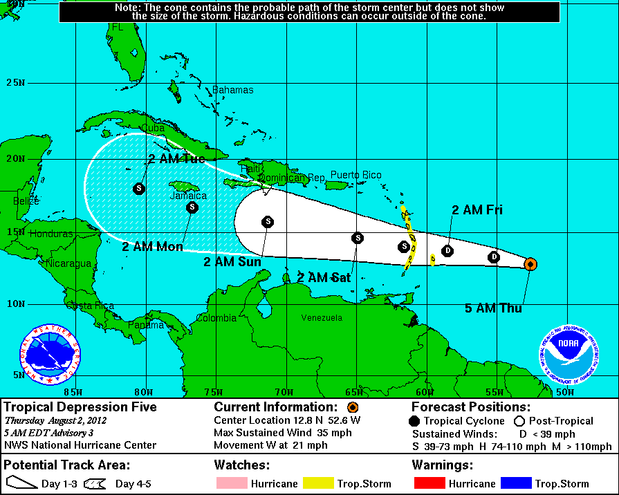
| Projected track of TD 5 (Ernesto by the weekend). (NHC) |
The tropics are showing signs of life again with the development of tropical depression five east of the Windward Islands. The storm has 35mph and is expected to slowly gain strength over the next 48 hours reaching tropical storm status and being named Ernesto by the weekend. Afterwards a general track towards the west northwest and Jamaica seems likely at this time.

No comments:
Post a Comment