 |
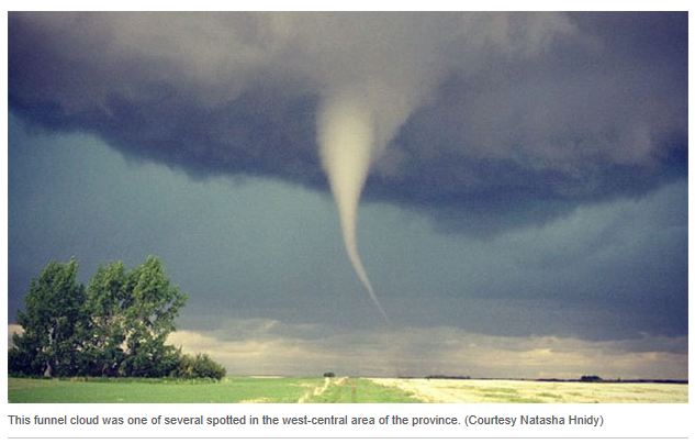
| Numerous funnel clouds and tornadoes were reported in west central Saskatchewan on Friday afternoon. Minimal damage and no injuries were reported. |
Environment Canada has issued a special weather statement for southern Ontario and Quebec as we look at our first prolonged heat of the season. Summer will arrive on Wednesday and right on schedule so will the high heat. We have had warm days this year, many as a matter of fact, but it looks like our first 32C (90F) temperatures will occur by Wednesday. High pressure will crest over the region with a strong southerly flow allowing warm air to move north along with increasing humidity. Humidex values will increase to near 40C on Wednesday and Thursday and air quality is expected to lower. The majority of the week will be dry, but several fronts will interact with the warm humid air, so there is a risk of some showers or thunderstorms, especially later in the week. A stronger front will arrive late Thursday into Friday bringing a more widespread threat of showers and storms, along with cooler temperatures on Friday. I expect highs in Montreal to be either side of 30C through Thursday. Overnight lows will be very mild, especially in urban areas, remaining in the low 20's (70's).
 |
| The leading edge of clouds from Hurricane Carlotta approach Mexico's Pacific coast on Friday. |
Active weather occurred on Friday and over the weekend as thunderstorms and tornadoes swept across Saskatchewan and into the northern high plains. Meanwhile a strong hurricane Carlotta moved into central Mexico over the weekend and dissipated rapidly. The once category 2 storm slammed into Puerto Escondido south of Acapulco late Friday with 80mph winds and drenching rain. Damage was widespread along the coast with numerous building damaged and trees down. Mudslides were responsible for the deaths of two young girls.

No comments:
Post a Comment